Pudding River facts for kids
Quick facts for kids Pudding River |
|
|---|---|

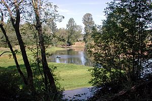
Pudding River near Aurora
|
|
|
Location of the mouth of the Pudding River in Oregon
|
|
| Country | United States |
| State | Oregon |
| County | Marion, Clackamas |
| Physical characteristics | |
| Main source | Waldo Hills east of Salem, Marion County 953 ft (290 m) 44°53′51″N 122°44′42″W / 44.89750°N 122.74500°W |
| River mouth | Molalla River near Canby, Clackamas County 62 ft (19 m) 45°17′54″N 122°43′07″W / 45.29833°N 122.71861°W |
| Length | 62 mi (100 km) |
| Basin features | |
| Basin size | 528 sq mi (1,370 km2) |
The Pudding River is a river in Oregon, United States. It is about 62 miles (100 km) long. The river flows into the Molalla River, which then joins the larger Willamette River. The area that the Pudding River and its smaller streams drain, called its basin, is about 528 square miles (1,368 km²).
Many smaller streams flow into the Pudding River. These include Silver Creek, Butte Creek, Abiqua Creek, and the Little Pudding River.
Long ago, the Pudding River used to flow directly into the Willamette River. Pictures from 1936 show this connection. Today, it joins the Molalla River first. The lower part of the Pudding River and its important smaller streams are home to different types of salmon and trout. These fish are very important for the river's natural environment.
River's Journey: Where the Pudding River Flows
The Pudding River starts in the western part of the Cascade Mountains. Its headwater creeks begin along a ridge where there is snow, but no glaciers. This area connects Mount Hood National Forest and Table Rock Wilderness to Silver Falls State Park and the rolling Waldo Hills east of Salem. The highest points along this ridge are between 3,750 and 4,250 feet (1,143 to 1,295 meters) high.
After leaving the Cascade Mountain foothills, important streams like Butte Creek come together near Woodburn. This is where the Pudding River begins to wind and curve. As it flows through the Pudding River Valley, its many smaller river areas are a key part of the rich farming lands in the lower Willamette Valley.
Two parts of the Pudding River join between the cities of Silverton and Mt. Angel. The river then continues north. It receives Abiqua Creek from the right side, about 2 miles (3 km) northwest of Silverton. North of Mt. Angel, Butte Creek flows into the Pudding River. Butte Creek comes down from the Cascade Range foothills, passing Scotts Mills. For most of its path, Butte Creek and the lower Pudding River form the border between Marion County and Clackamas County.
The Pudding River finally flows into the Molalla River. This happens just before the Molalla River joins the Willamette River in a flat, low-lying area that is part of the Molalla River State Park.
Fishing in the Pudding River
The upper part of the Pudding River is a great place for catch-and-release fishing. This means you can catch wild trout but must let them go. The lower part of the river has fish like bass and panfish.
The Pudding River is not stocked with fish from hatcheries. However, coastal cutthroat trout and rainbow trout swim into the upper river from streams like Drift, Butte, Silver, and Abiqua creeks. When fishing for trout in these areas, you can only use artificial flies and lures. It is not allowed to fish for winter-run steelhead (which are a type of rainbow trout) that spawn in the smaller streams.
When there is enough water flowing, usually until June, you can even use a boat in the very lowest parts of the river.
 | Jewel Prestage |
 | Ella Baker |
 | Fannie Lou Hamer |


