
Silverton, Oregon facts for kids
Quick facts for kids
Silverton, Oregon
|
||
|---|---|---|
_(marDA0188).jpg)
Cafes, coffee shops, and restaurants overlook Silver Creek from North Water Street in downtown Silverton.
|
||
|
||
| Nickname(s):
Gateway to Silver Falls
|
||
| Motto(s):
Oregon's Garden City
|
||

Location in Oregon
|
||
| Country | United States | |
| State | Oregon | |
| County | Marion | |
| Incorporated | 1854 | |
| Area | ||
| • Total | 3.54 sq mi (9.18 km2) | |
| • Land | 3.51 sq mi (9.08 km2) | |
| • Water | 0.04 sq mi (0.10 km2) | |
| Elevation | 266 ft (81 m) | |
| Population
(2020)
|
||
| • Total | 10,484 | |
| • Density | 2,989.45/sq mi (1,154.25/km2) | |
| Time zone | UTC-8 (Pacific) | |
| • Summer (DST) | UTC-7 (Pacific) | |
| ZIP code |
97381
|
|
| Area code(s) | 503 | |
| FIPS code | 41-67650 | |
| GNIS feature ID | 2411902 | |
| Website | www.silverton.or.us | |

Silverton is a city in Marion County, Oregon, United States. It's located along the 45th parallel, about 12 miles (19 km) northeast of Salem. The city sits on the eastern edge of the wide, flat Willamette Valley.
Silverton gets its name from Silver Creek, a stream that flows through the town. This creek starts at Silver Falls and flows into the Pudding River, which then joins the Willamette River.
The first community in the area, called Milford, was started in 1846. It had a sawmill and a store. Around 1853, another sawmill was built closer to where Silverton is today. The town of Silverton was officially planned and recorded in 1854.
People have lived in the Silverton area for about 6,000 years. In more recent history, the Kalapuya and Molala peoples lived here. They used to burn parts of the land each season, which made it good for farming. This attracted early settlers from Europe and America in the 1800s. Farming was the first big industry in Silverton and is still very important today.
Silverton is part of the Salem Metropolitan Statistical Area. It is also the main town for the Silver Falls School District. In 2020, the city had a population of 10,484 people.
Contents
Exploring Silverton's Location

Silverton is on the eastern side of the Willamette Valley. This valley is a rich, flat area that stretches between the Cascade Range mountains to the east (known as the Waldo Hills) and the Oregon Coast Range to the west.
Silverton is built on both sides of Silver Creek. This creek flows into the Pudding River, which then joins the Molalla River before flowing north into the Willamette River. Another creek, Abiqua Creek, also flows into the Pudding River, draining the land north of Silverton.
The city of Silverton is about 200 to 250 feet (61 to 76 meters) above sea level. The Waldo Hills to the south are steep and wooded, rising another 200 feet (61 meters). The land around Silverton is very fertile because of huge floods that happened long ago. About 13,000 years ago, massive floods from prehistoric Lake Missoula in Montana swept through eastern Washington and Oregon. These floods created the Columbia River Gorge. When the floodwaters reached ice jams in southwest Washington, they backed up and filled the entire Willamette Valley. This created a large body of water called Lake Allison, which was 300 to 400 feet (91 to 122 meters) deep. As Lake Allison slowly drained, it left behind layers of rich volcanic and glacial soil. This soil is about 180 to 200 feet (55 to 61 meters) thick in the Tualatin, Yamhill, and Willamette Valleys.

Before the mid-1800s, the Silverton area was mostly open grassland. It had small groups of Oregon white oak, ponderosa pine, and Douglas fir trees. Streams and river banks were lined with trees like Oregon white oak, red alder, bigleaf maple, and black cottonwood. These trees are still found today. However, widespread farming in the Willamette Valley between 1850 and 1870 changed the land. The Kalapuya people used to burn the valley plains seasonally, but this practice stopped. Large groups of Douglas fir and western red cedar, mixed with Oregon white oak, still grow in the Silverton area. You can see them especially on eastern hilltops and on the slopes of the Waldo Hills to the south. Most of these evergreen forests are made up of second- and third-growth trees because of many years of logging.
The United States Census Bureau states that Silverton covers a total area of 3.47 square miles (8.99 square kilometers). Of this, 3.43 square miles (8.88 square kilometers) is land, and 0.04 square miles (0.10 square kilometers) is water.
Silverton's Climate
Silverton has warm and dry summers, though sometimes it can get very hot. The average monthly temperature does not go above 71.6°F (22°C). According to the Köppen Climate Classification system, Silverton has a warm-summer Mediterranean. This means the climate is quite mild, even though Silverton is in a northern location. Temperatures usually don't change much. Most of the rain falls in the autumn and winter, with 40 to 50 inches (1000 to 1300 mm) of rain each year. Silverton's climate and soil are perfect for growing many different crops and for raising livestock.
| Climate data for Silverton | |||||||||||||
|---|---|---|---|---|---|---|---|---|---|---|---|---|---|
| Month | Jan | Feb | Mar | Apr | May | Jun | Jul | Aug | Sep | Oct | Nov | Dec | Year |
| Record high °F (°C) | 66 (19) |
71 (22) |
74 (23) |
86 (30) |
102 (39) |
100 (38) |
103 (39) |
104 (40) |
103 (39) |
91 (33) |
72 (22) |
66 (19) |
104 (40) |
| Mean daily maximum °F (°C) | 46.0 (7.8) |
50.6 (10.3) |
54.7 (12.6) |
59.0 (15.0) |
65.8 (18.8) |
71.5 (21.9) |
78.7 (25.9) |
79.2 (26.2) |
74.1 (23.4) |
62.9 (17.2) |
52.0 (11.1) |
45.6 (7.6) |
61.7 (16.5) |
| Mean daily minimum °F (°C) | 33.8 (1.0) |
35.4 (1.9) |
38.0 (3.3) |
40.6 (4.8) |
45.5 (7.5) |
50.6 (10.3) |
54.2 (12.3) |
54.5 (12.5) |
50.6 (10.3) |
44.0 (6.7) |
38.6 (3.7) |
33.9 (1.1) |
43.3 (6.3) |
| Record low °F (°C) | 4 (−16) |
6 (−14) |
19 (−7) |
28 (−2) |
32 (0) |
37 (3) |
42 (6) |
40 (4) |
34 (1) |
23 (−5) |
13 (−11) |
0 (−18) |
0 (−18) |
| Average precipitation inches (mm) | 6.83 (173) |
4.85 (123) |
5.11 (130) |
3.69 (94) |
2.83 (72) |
1.94 (49) |
0.69 (18) |
0.87 (22) |
1.77 (45) |
3.63 (92) |
7.08 (180) |
7.52 (191) |
46.82 (1,189) |
| Average precipitation days | 20 | 17 | 19 | 17 | 13 | 9 | 4 | 4 | 7 | 13 | 21 | 21 | 165 |
People of Silverton
| Historical population | |||
|---|---|---|---|
| Census | Pop. | %± | |
| 1880 | 229 | — | |
| 1890 | 511 | 123.1% | |
| 1900 | 656 | 28.4% | |
| 1910 | 1,588 | 142.1% | |
| 1920 | 2,251 | 41.8% | |
| 1930 | 2,462 | 9.4% | |
| 1940 | 2,925 | 18.8% | |
| 1950 | 3,146 | 7.6% | |
| 1960 | 3,081 | −2.1% | |
| 1970 | 4,301 | 39.6% | |
| 1980 | 5,168 | 20.2% | |
| 1990 | 5,635 | 9.0% | |
| 2000 | 7,433 | 31.9% | |
| 2010 | 9,222 | 24.1% | |
| 2020 | 10,484 | 13.7% | |
| U.S. Decennial Census | |||

In 2010, the census showed that 9,222 people lived in Silverton. There were 3,452 households and 2,442 families. The city had about 2,692 people per square mile (1,039 per square kilometer).
Most people in Silverton (84.1%) were White. About 12.7% were Hispanic or Latino. Other groups included Asian (1.0%), Native American (0.7%), and African American (0.2%).
About 34.6% of households had children under 18 living with them. Most households (54%) were married couples. The average household had 2.65 people, and the average family had 3.15 people.
The average age in Silverton was 35.8 years. About 28.4% of residents were under 18, and 17.2% were 62 or older. More women lived in Silverton (52.4%) than men (47.6%). Most adults (91.7%) had graduated from high school, and 29.1% had a college degree or higher. The average household income was $51,687. About 16.1% of the people lived at or below the poverty level.
Learning in Silverton

Silverton is the main town for the Silver Falls School District. This district also serves nearby Scotts Mills and communities near Silver Falls State Park. The district has twelve elementary schools.
Silverton High School has a campus on Pine Street that was finished in 2009. Voters approved money in 1994 to build a new high school in two parts. The first part was done in 1997 and could hold 500 students. The second part was finished in the summer of 2009, after voters approved more money in 2006. In autumn 2009, students moved from the old high school building to the new campus at 802 Schlador Street.
In 2006, Silverton and the Silver Falls School District worked together to create SCAN-TV. This is a local cable TV channel for the community.

In 2014, Silverton High School had 1,196 students. About 39% of these students were considered to be from low-income families. Also, 36.9% of students could get free or reduced-price lunches. About 14% of students had disabilities, and 11% were learning English. Compared to other similar high schools, students at Silverton High School did better than average in their studies. Most students (81.7%) were White, and 14.5% were Hispanic.
Silverton's Past
The first white settlers arrived at Silver Creek in the 1800s. In 1846, two settlers, James Smith and John Barger, built a sawmill along the creek. This first settlement was called Milford.
In 1854, the settlers left Milford and moved downstream to where Silverton is now. The town was first known as Silver Creek, but its name was changed to Silverton a year later. The town grew and was officially made a city in 1885. At that time, about 229 people lived there. Silverton has continued to grow, and today it has over 10,000 people.
Fun Places to Visit in Silverton

- Silverton is known as the gateway to Silver Falls State Park, which is Oregon's largest state park.
- Town Square Park in downtown Silverton is a small park with a footbridge over Silverton Creek and a memorial for soldiers.
- The Oregon Garden is an 80-acre (32 ha) botanical park located in Silverton. It's a great place to see many different plants.
- You can find a replica of the Shrine of Bobbie the Wonder Dog in Silverton. It includes a statue of Bobbie and his doghouse from the 1920s. Bobbie was a famous dog who traveled a very long distance to find his family.
- The Gordon House is located at the Oregon Garden. It is the only house in the Pacific Northwest designed by famous architect Frank Lloyd Wright that is open to the public. It's one of his famous Usonian designs.
- Silverton has many large murals. One famous mural is a copy of Norman Rockwell's The Four Freedoms. The original mural was destroyed when its building was torn down, but the community worked to create a new copy at 990 N. First St.
- Every August, Silverton celebrates the Homer Davenport Community Festival. This festival honors Homer Davenport (1867–1912), a famous writer, political cartoonist, and Arabian horse breeder from Silverton. The festival has exhibits, entertainment, an arts and crafts fair, rides, races, contests, a cartooning competition, a party, and a parade.
- The Palace Theater is a movie theater in Silverton's historic downtown. It was built in the early 1900s and was first called the Opera House. It has been showing movies since at least 1909. The Palace Theater has survived two fires, one in 1935 and another in 2012. The 2012 fire mostly damaged the snack area, but smoke caused other nearby businesses to close temporarily. The theater was once partly owned by Stu Rasmussen, who was the first openly transgender mayor in the United States.
Famous People from Silverton
- Greg Craven, an activist who made a popular video about climate change on YouTube.
- Homer Davenport, a political cartoonist.
- Scott Gragg, a former NFL player.
- Bill Grier, a college basketball coach.
- Donald Pettit, an astronaut.
- Stu Rasmussen, the first openly transgender mayor in the United States.
Silverton in Media
- The local newspaper is called The Appeal.
- The first bank robbery and chase scene in the 2001 movie Bandits was filmed in Silverton.
Images for kids
-
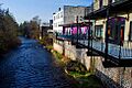
Cafes, coffee shops, and restaurants overlook Silver Creek from North Water Street in downtown Silverton.
-

The Flag of the City of Silverton, Oregon, designed by Benjamin Blair, Eliah Blair, Connor Hill, and Dmitri White, drawn by Benjamin and Eliah Blair
-
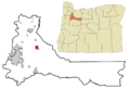
Location in Oregon
See also
 In Spanish: Silverton (Oregón) para niños
