
Aztec Butte facts for kids
Quick facts for kids Aztec Butte |
|
|---|---|

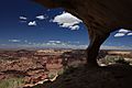
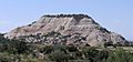
Southeast aspect, seen from Mesa Arch Trail
|
|
| Highest point | |
| Elevation | 6,312 ft (1,924 m) |
| Prominence | 232 ft (71 m) |
| Isolation | 1.54 mi (2.48 km) |
| Parent peak | Shaft Benchmark (6,329 ft) |
| Geography | |

Aztec Butte
Location in Utah

Aztec Butte
Location in the United States
|
|
| Location | Canyonlands National Park San Juan County, Utah, U.S. |
| Parent range | Colorado Plateau |
| Topo map | USGS Musselman Arch |
| Geology | |
| Age of rock | Jurassic |
| Type of rock | Navajo Sandstone |
| Climbing | |
| Easiest route | class 3 scrambling |
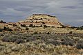
Aztec Butte is a small mountain, about 6,312 feet (1,924 meters) tall. It's located in the Island in the Sky area of Canyonlands National Park in Utah. This unique peak is made of white sandstone. This sandstone formed from ancient sand dunes about 170 million years ago, during the Jurassic Period.
The butte gets its name because it looks a bit like the Pyramid of the Sun in Mexico. That pyramid was built by the ancient Aztecs.
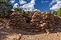
Long ago, people called Ancestral Puebloans lived in this area. They visited the Island in the Sky to hunt and gather food. They stored their food in special stone buildings called granaries. You can still see these well-preserved granaries near the top of Aztec Butte today. They were built between the years 1200 and 1300 AD.
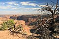
Hiking to Aztec Butte
You can hike to the top of Aztec Butte! The trail is about a half-mile long through flat, open land. After that, you'll have a quarter-mile climb, gaining about 200 feet in height. This part involves some scrambling, which means you might need to use your hands a bit to help you climb over rocks.
The path to the butte starts near the road that leads to Upheaval Dome. While you're in the area, you can also visit other cool spots. These include Mesa Arch, which is less than 1 mile (1.6 km) away, and the Green River Overlook.
Climate and Weather
The best times to visit Aztec Butte are in the spring and fall. The weather is usually mild and pleasant then.
This area has a Cold semi-arid climate. This means it's a desert climate, but it can get cold in winter. The region gets less than 10 inches (254 mm) of rain each year. Snowfall in winter is usually light.
| Climate data for Island in the Sky Visitor Center, elevation 5,666 ft (1,727 m), 1981-2010 normals, extremes 1981-2019 | |||||||||||||
|---|---|---|---|---|---|---|---|---|---|---|---|---|---|
| Month | Jan | Feb | Mar | Apr | May | Jun | Jul | Aug | Sep | Oct | Nov | Dec | Year |
| Record high °F (°C) | 58.6 (14.8) |
69.0 (20.6) |
79.8 (26.6) |
86.1 (30.1) |
98.5 (36.9) |
103.9 (39.9) |
106.4 (41.3) |
101.1 (38.4) |
97.9 (36.6) |
86.9 (30.5) |
71.0 (21.7) |
59.2 (15.1) |
106.4 (41.3) |
| Mean daily maximum °F (°C) | 38.1 (3.4) |
44.1 (6.7) |
54.9 (12.7) |
63.5 (17.5) |
74.2 (23.4) |
85.4 (29.7) |
91.7 (33.2) |
88.7 (31.5) |
79.5 (26.4) |
65.8 (18.8) |
49.7 (9.8) |
38.1 (3.4) |
64.6 (18.1) |
| Mean daily minimum °F (°C) | 20.8 (−6.2) |
25.8 (−3.4) |
33.3 (0.7) |
40.0 (4.4) |
49.5 (9.7) |
59.8 (15.4) |
66.0 (18.9) |
63.9 (17.7) |
54.9 (12.7) |
42.5 (5.8) |
31.1 (−0.5) |
21.3 (−5.9) |
42.5 (5.8) |
| Record low °F (°C) | −8.0 (−22.2) |
−12.4 (−24.7) |
10.4 (−12.0) |
16.3 (−8.7) |
26.0 (−3.3) |
28.7 (−1.8) |
46.0 (7.8) |
50.2 (10.1) |
27.6 (−2.4) |
9.2 (−12.7) |
6.2 (−14.3) |
−9.4 (−23.0) |
−12.4 (−24.7) |
| Average precipitation inches (mm) | 0.53 (13) |
0.50 (13) |
0.76 (19) |
0.72 (18) |
0.70 (18) |
0.45 (11) |
0.93 (24) |
1.04 (26) |
1.06 (27) |
1.30 (33) |
0.70 (18) |
0.58 (15) |
9.27 (235) |
| Average dew point °F (°C) | 18.6 (−7.4) |
21.8 (−5.7) |
23.3 (−4.8) |
25.7 (−3.5) |
29.5 (−1.4) |
32.7 (0.4) |
41.2 (5.1) |
45.1 (7.3) |
37.6 (3.1) |
29.5 (−1.4) |
23.2 (−4.9) |
17.9 (−7.8) |
28.9 (−1.7) |
| Source: PRISM | |||||||||||||
Images for kids
-
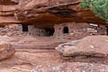
Aztec Butte granary
-
-
-
-
-


.jpg)
