Bailey's Crossroads, Virginia facts for kids
Quick facts for kids
Bailey's Crossroads, Virginia
|
|
|---|---|
|
Census-designated place (CDP)
|
|
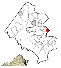
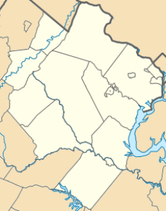
Location of Bailey's Crossroads in Fairfax County, Virginia
|
|
| Country | United States |
| State | Virginia |
| County | Fairfax |
| Area | |
| • Total | 2.05 sq mi (5.31 km2) |
| • Land | 2.05 sq mi (5.31 km2) |
| • Water | 0.0 sq mi (0.0 km2) |
| Elevation | 256 ft (78 m) |
| Population
(2020)
|
|
| • Total | 24,749 |
| • Density | 12,072/sq mi (4,660/km2) |
| Time zone | UTC−5 (Eastern (EST)) |
| • Summer (DST) | UTC−4 (EDT) |
| ZIP code |
22041
|
| Area code(s) | 703 |
| FIPS code | 51-04088 |
| GNIS feature ID | 1492501 |
Bailey's Crossroads is a special kind of community in Fairfax County, Virginia, United States. It's called a census-designated place (CDP). This means it's an area that the government counts for population, but it doesn't have its own local government like a city or town.
In 2020, about 24,749 people lived here. Bailey's Crossroads gets its name because it's where two important roads meet: State Route 7 (also known as Leesburg Pike) and State Route 244 (Columbia Pike).
Contents
Discovering Bailey's Crossroads' Name
Bailey's Crossroads is named after the famous Bailey family, who were well-known for their circuses. One of America's first circus showmen, Hachaliah Bailey, lived here.
The Circus Connection
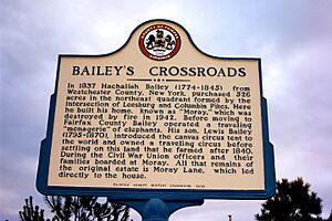
In 1808, Hachaliah Bailey bought an Indian elephant. This was one of the first elephants ever seen in the United States! He needed a place for his circus animals to stay during the winter. So, in 1837, he moved to Virginia. He bought a large piece of land near what is now the intersection of Leesburg Pike and Columbia Pike.
On this land, he built a huge house called "Bailey's Mansion." Some say it had 100 rooms! This mansion was located where Durbin Place is today.
Circuses were a big part of the Bailey family's life. Hachaliah's son, Lewis Bailey, ran a traveling circus. He was one of the first to use canvas circus tents. In 1840, Lewis settled down to farm in Bailey's Crossroads.
Another family member, James Anthony McGuiness, later known as James Anthony Bailey, became a circus talent. He helped create the famous Barnum and Bailey Circus. This circus later joined with the Ringling Brothers Circus to form the even bigger Ringling Brothers and Barnum and Bailey Circus.
Farming Life in Bailey's Crossroads
Lewis Bailey was one of the first people from the North to settle in Fairfax County to farm. In 1837, his father, Hachaliah, bought hundreds of acres of land here. Lewis then bought 150 acres from his father.
When Lewis first bought the land, it was not in great shape. The soil was poor, and there weren't many buildings. His neighbors even wondered if he could ever fill his small barn with hay! But Lewis was smart. Within ten years, he had a great herd of dairy cows. He became one of the most successful farmers in the area. The Bailey family was also important in the Dulin Methodist Church.
A Look at Bailey's Crossroads' History
Hachaliah Bailey, the founder of one of America's first circuses, moved to Northern Virginia in 1837. He bought the land around the intersection of Leesburg Pike and Columbia Pike. This is how Bailey's Crossroads got its name. It also became the winter home for his circus animals.
Bailey's Crossroads During the Civil War
The American Civil War brought big changes to Bailey's Crossroads. In the summer of 1861, this area became a "no man's land." It was caught between the Union and Confederate armies. Life was very difficult.
Virginia decided to leave the Union in May 1861. Many people from the North who lived in Fairfax County felt unsafe. Their Southern neighbors looked at them with suspicion. In July 1861, the Union Army lost a major battle at Manassas. The Confederate Army quickly followed them toward Washington.
Confederate soldiers took over Falls Church and Munson's Hill, which overlooked Bailey's Crossroads. They built a simple fort on Munson's Hill. From there, they could see everything. This made Bailey's Crossroads a dangerous place. Confederate sharpshooters often shot Union soldiers. It was very risky to walk on Leesburg Pike.
On September 3, 1861, there was a small fight between the two sides. The Union Army had eight soldiers hurt, but the Confederates had none.
Changes in Control
The situation changed on September 28, 1861. The Confederate Army quietly left Munson's Hill, Upton's Hill, and Falls Church. They moved to Manassas, where they built stronger defenses. They believed these areas were too far from their supply lines. They thought the Union Army could easily cut off their supplies. Manassas was better because it had good railroad and road connections.
After the Confederates left, Union troops quickly moved back into the area. A very important event happened at Bailey's Crossroads on November 20, 1861. Thousands of Union troops marched and paraded. President Abraham Lincoln, newspaper reporters, and many people from Washington watched them.
The army chose Bailey's Crossroads for this event because it was a large, flat area. To prepare, they only needed to remove the fences between farms.
Bailey's Crossroads in the 20th Century
After the Civil War, Bailey's Crossroads went back to being a quiet farming community. It stayed rural until after World War II. Then, a lot of new buildings and homes were built.
Today, Leesburg Pike is a busy commercial street. There are many apartments and homes nearby. A shopping center called Culmore is famous. It has given its name to the apartment buildings behind it. Many Latino immigrants live in these apartments. "Culmore" is now a well-known part of Bailey's Crossroads. Close by is Lake Barcroft, which has nice homes along its shore.
In the 1960s, plans for Washington's Metro subway system included a line under Columbia Pike. This line was supposed to go through Bailey's Crossroads. Because of this plan, a huge complex of tall buildings called Skyline City was built. It was located where the Metro stations were planned to be. However, the Metro plans changed. The subway line was built along the I-66 highway instead.
Understanding Bailey's Crossroads' Location
Bailey's Crossroads is located at 38°50′58″N 77°7′45″W / 38.84944°N 77.12917°W. It covers about 2.0 square miles (5.3 km2) of land. The area is mostly flat, with Munson's Hill to the west. This flat land is why the Union Army chose it for their large troop review during the Civil War.
Bailey's Crossroads is formed by the meeting of two important roads. State Route 7 connects Alexandria, Virginia with the Shenandoah Valley. State Route 244 (Columbia Pike) connects the Pentagon and Washington, D.C. with Annandale, Virginia.
The most noticeable landmark here is Skyline Center. It's a group of tall 26-story apartment and office buildings built in the 1970s. A branch of Northern Virginia Community College and offices for the U.S. Department of Defense are also nearby. Many people of Hispanic background live in this neighborhood. The largest Giant Food supermarket is also located here. While the closest Metrorail station is a few miles away, bus service on Columbia Pike has gotten better.
The exact borders of Bailey's Crossroads are not always clear. Since it's not an official town, it doesn't have fixed boundaries. The United States Census Bureau uses one definition, and different parts of the Fairfax County government use others. Plans for economic development usually focus on the commercial areas.
However, as a general neighborhood, Bailey's Crossroads is considered to be larger. It borders the Lake Barcroft neighborhood to the southwest. Its western edge is marked by Blair Road, Beachway Drive, Nevius Street, and Mansfield Road. North of Leesburg Pike, its area is generally defined by Glen Carlyn and Carlin Springs roads.
Local Government and Services
Fairfax County Public Schools manages the public schools in the area. Most children living here attend Glen Forest Elementary School. The local schools then feed into Justice High School.
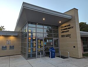
The Fairfax County Public Library operates the Culmore Community Library. This library is in the Culmore area. It has books and materials in both Spanish and English.
A United States Post Office is located in Culmore. It serves the Bailey's Crossroads ZIP code of 22041. Even though the postal service often uses "Falls Church" for this ZIP code, many businesses and residents use "Bailey's Crossroads." This helps avoid confusion with deliveries and services. The State of Virginia and Fairfax County, Virginia also accept "Bailey's Crossroads" as a valid address for official papers.
In 2010, the Bailey's Crossroads Volunteer Fire Department gave its land, firehouse, and most equipment to the Fairfax County Fire & Rescue Department. In return, they got a new facility. Now, Fire Station 10 is run by the Fairfax County Fire & Rescue Department. It has full-time firefighters and paramedics working 24/7. The volunteers still own three medic units at the station. Two are used by the county, and the third is used by the volunteers.
Who Lives in Bailey's Crossroads?
| Historical population | |||
|---|---|---|---|
| Census | Pop. | %± | |
| 1970 | 7,295 | — | |
| 1980 | 12,564 | 72.2% | |
| 1990 | 19,507 | 55.3% | |
| 2000 | 23,166 | 18.8% | |
| 2010 | 23,643 | 2.1% | |
| 2020 | 24,749 | 4.7% | |
In 2020, the population of Bailey's Crossroads was 24,749 people. There were about 9,796 homes. The population density was about 12,072 people per square mile.
The community is very diverse. About 31.56% of residents were White, 16.11% were African American, and 13.01% were Asian. A large part of the population, 38.18%, identified as Hispanic or Latino.
The average age of people living here was 33.9 years old. About 24.6% of the people were under 18. About 13.5% were 65 years or older. Many people, 61.9%, speak a language other than English at home. Also, 49.0% of residents were born outside the United States.
The average income for a household in Bailey's Crossroads was $78,286. About 21.3% of the population lived below the poverty line. This included 35.2% of those under 18.
Famous People from Bailey's Crossroads
- Charlie Garner, a former American football player
- Penny Moore, a former WNBA basketball player for the Charlotte Sting and Washington Mystics
- Franz Stahl and Pete Stahl, punk rock musicians
See also
 In Spanish: Bailey's Crossroads (Virginia) para niños
 | James Van Der Zee |
 | Alma Thomas |
 | Ellis Wilson |
 | Margaret Taylor-Burroughs |


