
Balch Creek facts for kids
Quick facts for kids Balch Creek |
|
|---|---|

Waterfall in Macleay Park
|
|

Balch Creek in Portland and unincorporated Multnomah County. Dashed black line shows stream course through storm sewer.
|
|

Location of the mouth of Balch Creek in Oregon
|
|
| Country | United States |
| State | Oregon |
| County | Multnomah |
| Physical characteristics | |
| Main source | Tualatin Mountains (West Hills) Portland, Multnomah County, Oregon 1,116 ft (340 m) 45°32′34″N 122°45′35″W / 45.54278°N 122.75972°W |
| River mouth | Willamette River Portland, Multnomah County, Oregon 46 ft (14 m) 45°32′16″N 122°42′41″W / 45.53778°N 122.71139°W |
| Length | 3.5 mi (5.6 km) |
| Basin features | |
| Basin size | 3.5 sq mi (9.1 km2) |
Balch Creek is a small stream, about 3.5-mile (5.6 km) long, in Oregon, USA. It flows into the Willamette River. The creek starts high up in the Tualatin Mountains, also known as the West Hills. It then flows through a canyon and a large city park called Forest Park in Portland.
Part of Balch Creek flows above ground, but the lower section goes into a large pipe. This pipe carries the water underground until it reaches the Willamette River. The creek is named after Danford Balch, an early settler who lived near the creek in the 1800s.
The land around Balch Creek is mostly made of ancient lava rock. The upper parts of the creek's area include homes, a nature sanctuary run by the Audubon Society of Portland, and parts of Forest Park. This area has thick forests with Douglas-fir, western redcedar, and western hemlock trees. Many animals live here, including 62 types of mammals and over 112 types of birds. The creek is also home to a small number of coastal cutthroat trout. In 2005, Balch Creek was one of the cleanest waterways in Portland.
While the upper and middle parts of the creek are natural areas, the lower part is mostly industrial. This area used to be a lake called Guild's Lake. In 1905, a big event called the Lewis and Clark Centennial Exposition was held there. After that, the lake was filled in to make space for factories and businesses.
Contents
Where Does Balch Creek Flow?
Balch Creek starts in the Forest Park neighborhood in Multnomah County. This is at the top of the West Hills. The creek flows generally east for about 3.5 miles (5.6 km) until it joins the Willamette River. The Willamette River then flows into the Columbia River.
The creek begins at an elevation of about 1,116 feet (340 m) above sea level. By the time it reaches the Willamette River, it is only about 46 feet (14 m) above sea level. This means it drops a total of 1,070 feet (330 m)! Most of this drop happens in the first 2.5 miles (4.0 km) of its journey.
From its source, Balch Creek flows through private land near Forest Park. It then enters the city of Portland and the Audubon Society of Portland sanctuary. As it flows, it picks up water from smaller streams. The creek then enters Macleay Park, which is part of Forest Park.
For about 0.25 miles (0.40 km), the creek flows next to the Wildwood Trail, a popular hiking path. It then passes a old stone building called the Stone House. From there, Balch Creek follows the Lower Macleay Trail for about 0.8 miles (1.3 km).
Near Northwest Thurman Street, about 1 mile (1.6 km) from its end, the creek flows into a large pipe called a storm sewer. This pipe is 84-inch (210 cm) wide. The city first put the creek into a pipe in the early 1900s. The water from the pipe then flows into the Willamette River.
How Much Water Flows?
The city of Portland measured how much water flows in Balch Creek. This was done from 1996 to 2002 where the creek goes underground in Macleay Park.
- In summer, the average flow was about 0.2 cubic feet per second (0.0057 m3/s). It could be as high as 60 cubic feet per second (1.7 m3/s) after heavy rain, but sometimes it had no flow at all.
- In winter, the average flow was about 1.9 cubic feet per second (0.054 m3/s). It could reach 73 cubic feet per second (2.1 m3/s) during big storms.
The amount of water in the creek changes a lot with the weather. After many days of rain, the flow can be much higher.
The Land Around Balch Creek
The land under Balch Creek is made of hardened lava from ancient volcanoes. About 16 million years ago, during a time called the Middle Miocene, huge lava flows covered a vast area, including what is now the Willamette Valley. These lava flows created the steep slopes and rocky cliffs you can see in parts of Forest Park.
Later, wind blew fine dirt, called silt, over the lava. This silt can become unstable when wet, which means there's a risk of landslides in the hills. This is why many parts of the hills have not been built on.
Between 19,000 and 15,000 years ago, massive ice age floods, known as the Missoula Floods, swept through the area many times. These floods brought huge amounts of dirt and rocks, creating new flat areas along the rivers. The lower part of Balch Creek used to flow through swampy lands and shallow lakes, like the historic Guild's Lake.
A Look Back in Time
How Places Got Their Names
Multnomah County is named after the Native American people who lived here before European settlers arrived. The Multnomah people were part of the Chinookan group. They lived on Sauvie Island and the mainland near the Willamette River, downstream from Balch Creek. However, the swampy areas near the lower creek were not their main living places. By the 1830s, diseases brought by explorers and traders greatly reduced the native population.
Historic Guild's Lake, located near the Willamette River in the lower Balch Creek area, was named after Peter Guild. He was one of the first European American settlers and claimed nearly 600 acres (2.4 km2) of land there in 1847.
The creek itself is named after Danford Balch. He settled on 346-acre (1.40 km2) of land upstream from Peter Guild's property in 1850.
Macleay Park is named after Donald Macleay. He was a businessman in Portland who bought what used to be the Balch property. In 1897, he gave the land to the city to create a park. He asked that the city provide transportation for hospital patients to the park and build paths wide enough for wheelchairs.
Portland's First Water Supply
Balch Creek was an important source of drinking water for Portland in the mid-1800s. In 1857, two early business owners, Stephen Coffin and Finice Caruthers, created the city's first public water system. They piped water from Caruthers Creek using hollowed-out fir logs. In the 1860s, the Portland Water Company added water from Balch Creek to this system. The water was sent to a wooden storage tank.
However, there were often water shortages and pollution problems. Because of this, Portland eventually switched its main water supply to the Bull Run River in the Cascade Range. This new source began supplying most of Portland's drinking water in 1895.
Industry Grows Here

One of the first businesses in the Guild's Lake area was a sawmill built in the 1880s. Even though much of the land was empty, lumber mills, grain storage buildings, railroads, and docks started to appear along the riverfront. The Guild's Lake Rail Yard, built by the Northern Pacific Railway in the 1880s, became a very important place for trains to switch tracks.
In 1905, the Lewis and Clark Centennial Exposition was held on an artificial island in Guild's Lake. This big event helped the area grow. After the exposition, developers filled in the lake and the surrounding swampy land. They used soil from the West Hills and mud dredged from the Willamette River. By the mid-1920s, Guild's Lake was completely gone.
Because it was close to highways, river terminals, and train tracks, the Guild's Lake area became Portland's most important industrial zone. After World War II, large industries like chemical processing, metal manufacturing, and storage facilities grew here. In 2001, the Portland City Council decided to protect the Guild's Lake area as an "industrial sanctuary." This plan helps keep the area strong for businesses in the long term.
Balch Creek's Natural World

The entire area that drains into Balch Creek, called its watershed, covers about 3.5 square miles (9.1 km2). About 27 percent of this land is used for parks and open spaces. Another 20 percent is set aside for heavy industry near the Willamette River.
About 1,600 people lived in the Balch Creek watershed in 2000, and about 6,700 people worked there. The average rainfall in the watershed is about 40 inches (1,000 mm) per year. Most of this rain falls between November and April. Sometimes, heavy rain can cause minor flooding near where the creek enters the pipe.
Plants of the Watershed

The Balch Creek watershed is home to many different plants. The lower part of the watershed used to be a mix of open water, wetlands, grasslands, and forests. However, settlers in the 1800s cut down many trees and filled in the wetlands. Today, the lower floodplain is mostly covered by buildings and parking lots.
However, the hills above the floodplain still have many forests. About 65 percent of the watershed is covered by these protected hill forests. Most of these forests are relatively young. Common trees include Douglas fir, big leaf maple, willow, western hemlock, and red alder. There are also a few very old Douglas fir trees that have been undisturbed for over 250 years. The largest tree in Forest Park, Heritage Tree 134, is a Douglas-fir near the Stone House. It is 242 feet (74 m) tall!
The forests also have a rich understory of shrubs and flowering plants. These include ferns, Oregon-grape, vine maple, salal, and salmonberry. You can also find wildflowers like wild ginger, vanilla leaf, and trillium.
Unfortunately, some invasive plant species, like English ivy, European holly, and Himalayan blackberry, have spread in the area. These plants can harm the native plants and animals. Groups like the No Ivy League work to remove these invasive plants and plant native species.
Animals of the Watershed

In the past, Balch Creek likely had many types of fish, including salmon. But after the wetlands were filled and the lower creek was put into a pipe, fish could no longer travel to and from the Willamette River. Today, the industrial parts of the watershed have no water habitats for fish.
However, above the pipe, the water habitat is still very good. Balch Creek and its smaller streams are home to a group of coastal cutthroat trout that can grow up to about 7 inches (18 cm) long. In 2005, Balch Creek was the only major waterway in Portland that met state standards for clean water.
The wildlife in the Balch Creek watershed is greatly affected by nearby natural areas, especially Forest Park. Animals can move easily between Forest Park and other areas like the Tualatin River valley and the Columbia River.
Many different animals live in Forest Park:
- Mammals: 62 species, including northern flying squirrels, black-tailed deer, bobcats, coyotes, and Roosevelt elk.
- Birds: Over 112 species, such as blue grouse, great horned owls, hairy woodpeckers, and ospreys.
- Amphibians: rough-skinned newts, Pacific tree frogs, and salamanders can be found in the Audubon Society pond.
Sadly, urban development and pollution have reduced or removed large predators like wolves and bears. This has led to more small predators like weasels and raccoons. Roads also make it hard for large animals to move around safely.
The invasive plants, like English ivy, make the habitat less diverse and less supportive for native insects and amphibians. To help, local groups work to remove ivy, plant native species, and protect the areas along the creek.
Images for kids
-
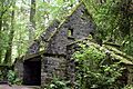
The federal Works Progress Administration built this stone structure near Balch Creek in the 1930s. The city maintained it as a public restroom until 1962.

