
Baldingen, Aargau facts for kids
Quick facts for kids
Baldingen
|
||
|---|---|---|
 |
||
|
||

Baldingen
Location in Switzerland

Baldingen
Location in Canton of Aargau
|
||
| Country | Switzerland | |
| Canton | Aargau | |
| District | Zurzach | |
| Area | ||
| • Total | 2.83 km2 (1.09 sq mi) | |
| Elevation | 548 m (1,798 ft) | |
| Population
(December 2020)
|
||
| • Total | 267 | |
| • Density | 94.3/km2 (244.4/sq mi) | |
| Postal code |
5333
|
|
| Surrounded by | Böbikon, Endingen, Lengnau, Rekingen, Tegerfelden, Unterendingen | |

Baldingen is a village in Switzerland. It used to be its own town, called a municipality. It is located in the Aargau area, which is like a state or canton, within the Zurzach district. Baldingen is very close to the border with Germany, only about 2 kilometers away.
On January 1, 2022, Baldingen and several other nearby towns like Böbikon and Rekingen joined together. They all became part of a new, larger municipality called Zurzach.
Contents
History of Baldingen
Baldingen was first written about in the year 1317. However, people called the Alamanni had already lived in this area for hundreds of years before that.
Early Times and Rulers
During the Middle Ages (a long time ago, between the 5th and 15th centuries), a small noble family lived in Baldingen. They were important in the area. Until 1415, the powerful Habsburg family had control over Baldingen. After the Habsburgs lost control of the Aargau region, Baldingen became part of the County of Baden. Many different private owners then had rights over the local courts and justice.
Church and Community
Baldingen was part of the main church area of Zurzach until 1883. Then, Baldingen and a nearby town called Böbikon formed their own church community. The local church, called St. Agatha, was built in 1898. It is a Catholic church with a special design. It mixes old-style Gothic Revival with newer Art Nouveau elements. Charles Moser was the architect who designed it.
Baldingen's Economy and Growth
For a long time, Baldingen's main way of making money was through farming. In 1970, more than half of the jobs (54%) were in agriculture. Even in 1990, about a quarter (23%) of jobs were still in farming. Today, most people who live in Baldingen work outside the village. This is because there are not many big factories or businesses in Baldingen itself.
The number of people living in Baldingen grew a lot after the 1980s. Many new houses were built, especially single-family homes. These new houses helped connect the two main parts of the village.
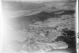
Geography of Baldingen

Baldingen covers an area of about 2.83 square kilometers (1.09 square miles).
Land Use
- About 56.9% of the land is used for farming. This includes fields for crops, pastures for animals, and areas for fruit trees.
- About 31.1% of the land is covered by forests. These are mostly thick, natural forests.
- The remaining 11.3% of the land is used for buildings and roads. About 5.7% is for houses and other buildings, and 5.3% is for transportation like roads.
Village Parts and Elevation
Baldingen is made up of two main parts:
- Oberbaldingen is located higher up, on top of a hill called Mount Spornegg. It is about 559 meters (1,834 feet) above sea level.
- Unterbaldingen is lower down, on the eastern side of the hill. It is about 460 meters (1,509 feet) above sea level.
These two parts of the village have only recently grown enough to connect with each other. The highest point in Baldingen is 583 meters (1,913 feet) high, and the lowest point is 400 meters (1,312 feet) high.
Neighboring Towns
Baldingen is surrounded by several other towns. To the north is Rekingen, to the east is Böbikon, and to the south-east is Lengnau. To the south is Unterendingen, and to the west is Tegerfelden.
Coat of Arms
The official symbol, or blazon, of Baldingen's town coat of arms shows three golden linden leaves with branches. These are set against a blue background.
People and Population
Baldingen has a population of 267. About 6.6% of the people living in Baldingen are from other countries. Over the last 10 years (1997–2007), the population has grown by about 4.6%.
Languages Spoken
Most people in Baldingen (98.0%) speak German. A small number of people also speak French (0.8%) or Dutch (0.4%).
Age Groups
Looking at the age of people in Baldingen (as of 2008):
- About 10.7% are children aged 0-9 years old.
- About 19.9% are teenagers aged 10-19 years old.
- About 8.9% are young adults aged 20-29 years old.
- About 8.9% are adults aged 30-39 years old.
- About 25.8% are adults aged 40-49 years old.
- About 14.1% are adults aged 50-59 years old.
- About 5.8% are older adults aged 60-69 years old.
- About 2.7% are older adults aged 70-79 years old.
- About 2.7% are older adults aged 80-89 years old.
- There is also 1 person who is 90 years old or older.
Homes and Households
In 2000, there were 84 private homes or apartments in Baldingen. On average, there were 3 people living in each home. About 81% of the homes were owned by the people living in them, meaning they did not pay rent. In 2008, 62.1% of all homes were single-family houses. There was only 1 empty apartment, meaning a very low vacancy rate of 1.1%.
Voting Habits
In the 2007 national election, the most popular political party in Baldingen was the SVP. They received about 45.45% of the votes. The next most popular parties were the CVP (20.42%) and the SP (10.38%). About 55% of the people who could vote actually did vote in that election.
Population Over Time
The number of people living in Baldingen has changed over many years:
| Historical population | ||
|---|---|---|
| Year | Pop. | ±% |
| 1799 | 236 | — |
| 1850 | 336 | +42.4% |
| 1900 | 183 | −45.5% |
| 1950 | 182 | −0.5% |
| 1980 | 144 | −20.9% |
| 2000 | 249 | +72.9% |
Economy
In 2007, Baldingen had a very low unemployment rate of 1.13%. This means almost everyone who wanted a job had one.
Types of Jobs
- Primary Sector: In 2005, 26 people worked in the primary sector, which mostly means farming and getting raw materials. There were 9 businesses in this area.
- Secondary Sector: Nine people worked in the secondary sector, which includes manufacturing and building things. There were 2 businesses here.
- Tertiary Sector: Eighteen people worked in the tertiary sector, which includes services like shops, offices, and healthcare. There were 10 businesses in this sector.
Commuting and Transportation
In 2000, 116 people lived in Baldingen and worked. Most of them (about 76.7%) traveled outside Baldingen for their jobs. Only 7 people came into Baldingen to work. There were 34 jobs available in the village itself.
When people traveled to work:
- 9.2% used public transportation, like buses or trains.
- 55.8% used their own private car.
Religion

Based on information from 2000:
- 121 people (48.6%) were Roman Catholic.
- 75 people (30.1%) belonged to the Swiss Reformed Church.
Education
People in Switzerland are generally well-educated. In Baldingen, about 76.9% of adults (aged 25–64) have finished high school or gone on to higher education, like a university. In the 2008/2009 school year, 33 students from Baldingen attended primary school in the municipality.
Sights to See
The main sight in Baldingen is the Catholic parish church of St. Agatha. It was built in 1898. The church has a mix of New Gothic and Art Nouveau styles. It was designed by a famous architect named Karl Moser, who also designed the Paulus church in Basel.
See also
 In Spanish: Baldingen para niños
