Barnwell, South Carolina facts for kids
Quick facts for kids
Barnwell, South Carolina
|
||
|---|---|---|

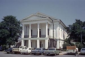
Barnwell County Courthouse, June 1968
|
||
|
||
| Nickname(s):
Gateway to the Low Country, Red Hill
|
||

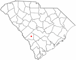
Location of Barnwell, South Carolina
|
||
| Country | United States | |
| State | South Carolina | |
| County | Barnwell | |
| Town | 1829 | |
| Government | ||
| • Type | Mayor-Council-Commission | |
| Area | ||
| • Total | 7.99 sq mi (20.70 km2) | |
| • Land | 7.84 sq mi (20.31 km2) | |
| • Water | 0.15 sq mi (0.38 km2) | |
| Elevation | 217 ft (66 m) | |
| Population
(2020)
|
||
| • Total | 4,652 | |
| • Density | 593.22/sq mi (229.03/km2) | |
| Time zone | UTC-5 (Eastern (EST)) | |
| • Summer (DST) | UTC-4 (EDT) | |
| ZIP codes |
29812-29813
|
|
| Area codes | 803, 839 | |
| FIPS code | 45-04060 | |
| GNIS feature ID | 1244965 | |
Barnwell is a city in South Carolina, United States. It is the main town, or county seat, of Barnwell County. The city is located along U.S. Route 278. In 2010, about 4,750 people lived there. By 2020, the population was 4,652.
Contents
About Barnwell
Where is Barnwell Located?
Barnwell is in the eastern part of Barnwell County. A small stream called Turkey Creek flows through the city. This creek is part of the Salkehatchie River system. It even forms a small lake called Lake Brown in the northern part of the city.
U.S. Route 278 goes through Barnwell. This road connects Barnwell to Allendale, which is about 17 miles south. It also leads to Augusta, Georgia, about 42 miles northwest. Other state roads like Highway 3, Highway 70, and Highway 64 also pass through. Highway 64 takes you to the Savannah River Site, a special nuclear area, about 6 miles west.
The city covers about 7.99 square miles (20.7 square kilometers) in total. Most of this area is land, with a small part being water.
Who Lives in Barnwell?
| Historical population | |||
|---|---|---|---|
| Census | Pop. | %± | |
| 1880 | 648 | — | |
| 1890 | 937 | 44.6% | |
| 1900 | 1,329 | 41.8% | |
| 1910 | 1,324 | −0.4% | |
| 1920 | 1,903 | 43.7% | |
| 1930 | 1,834 | −3.6% | |
| 1940 | 1,922 | 4.8% | |
| 1950 | 2,005 | 4.3% | |
| 1960 | 4,568 | 127.8% | |
| 1970 | 4,439 | −2.8% | |
| 1980 | 5,572 | 25.5% | |
| 1990 | 5,255 | −5.7% | |
| 2000 | 5,035 | −4.2% | |
| 2010 | 4,750 | −5.7% | |
| 2020 | 4,652 | −2.1% | |
| U.S. Decennial Census | |||
Barnwell's population has changed over the years. In 1880, there were 648 people. The population grew quite a bit by 1960, reaching 4,568. In 2020, the city had 4,652 residents.
The people living in Barnwell come from different backgrounds. According to the 2020 census, about 51.44% of the people were Black or African American. About 39.7% were White. There were also smaller groups of Asian, Native American, Pacific Islander, and people of mixed races. About 2.09% of the population was Hispanic or Latino.
Barnwell's Story
In 1785, the area was first called Winton County. It was renamed Barnwell in 1798. The county and its main town were named after John Barnwell. He was a leader in the Revolutionary War. Barnwell County used to be much larger. It stretched from the Savannah River almost to the Atlantic Ocean.
In 1832, the South Carolina Railroad was built. This railroad connected Charleston to Hamburg, near Augusta, Georgia. Because of this railroad, new towns like Blackville and Williston grew in the mid-1800s.
The Civil War Years
Barnwell played a part in the Civil War. Many people from Barnwell supported the Confederate side. One important person was Johnson Hagood. He was a Confederate General. Later, he became the governor of South Carolina from 1880 to 1882.
During the war, Union General Judson Kilpatrick came to Barnwell. His soldiers were part of General Sherman's March to the Sea. An interesting story from that time is that Kilpatrick's horses were kept in the Episcopal Church of the Holy Apostles. The church's baptismal font was even used to give water to the horses!
Historic Places
Several buildings and sites in Barnwell are very old and important. They are listed on the National Register of Historic Places. These include Banksia Hall, Bethlehem Baptist Church, Church of the Holy Apostles Rectory, Church of the Holy Apostles, Episcopal, and Old Presbyterian Church. These places help us remember Barnwell's past.
Learning and Weather
Schools and Libraries
Barnwell has a public library. It is part of the ABBE Regional Library System. This library provides books and resources for everyone in the community.
Barnwell's Climate
The weather in Barnwell is generally warm. It has a Humid subtropical climate. This means it has high temperatures and rain throughout the year.
| Climate data for Barnwell, South Carolina | |||||||||||||
|---|---|---|---|---|---|---|---|---|---|---|---|---|---|
| Month | Jan | Feb | Mar | Apr | May | Jun | Jul | Aug | Sep | Oct | Nov | Dec | Year |
| Mean daily maximum °C (°F) | 14 (58) |
16 (60) |
19 (67) |
24 (76) |
29 (84) |
32 (90) |
33 (91) |
32 (90) |
30 (86) |
24 (76) |
19 (66) |
14 (58) |
24 (75) |
| Mean daily minimum °C (°F) | 4 (39) |
4 (40) |
8 (46) |
12 (53) |
17 (62) |
21 (69) |
22 (72) |
22 (71) |
19 (66) |
13 (55) |
7 (44) |
4 (39) |
13 (55) |
| Average precipitation mm (inches) | 94 (3.7) |
100 (4.1) |
110 (4.5) |
86 (3.4) |
81 (3.2) |
110 (4.2) |
130 (5.1) |
120 (4.7) |
89 (3.5) |
61 (2.4) |
66 (2.6) |
86 (3.4) |
1,130 (44.6) |
| Source: Weatherbase | |||||||||||||
Famous People from Barnwell
- Solomon Blatt, Jr., a judge for the United States District Court.
- Solomon Blatt, Sr., a state representative in South Carolina.
- Edgar Brown, a state senator in South Carolina.
- James Brown, a famous R&B singer, songwriter, and dancer.
- Troy Brown, a wide receiver for the New England Patriots football team.
- Brian J. Gaines, the state Comptroller General.
- Joseph Emile Harley, a governor of South Carolina.
- Barry Miller, a lawyer and politician from Texas.
- James T. Moore, a Marine Corps lieutenant general during World War II.
- R. Winston Morris, a professional tuba player and teacher.
See also
 In Spanish: Barnwell (Carolina del Sur) para niños
 | James Van Der Zee |
 | Alma Thomas |
 | Ellis Wilson |
 | Margaret Taylor-Burroughs |


