Barrow County, Georgia facts for kids
Quick facts for kids
Barrow County
|
|||
|---|---|---|---|

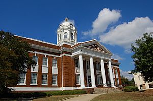
Barrow County Courthouse in Winder
|
|||
|
|||

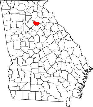
Location within the U.S. state of Georgia
|
|||
 Georgia's location within the U.S. |
|||
| Country | |||
| State | |||
| Founded | July 7, 1914 | ||
| Named for | David Crenshaw Barrow Jr. | ||
| Seat | Winder | ||
| Largest city | Winder | ||
| Area | |||
| • Total | 163 sq mi (420 km2) | ||
| • Land | 160 sq mi (400 km2) | ||
| • Water | 2.6 sq mi (7 km2) 1.6%% | ||
| Population
(2020)
|
|||
| • Total | 85,588 | ||
| • Estimate
(2023)
|
92,792 |
||
| • Density | 525.1/sq mi (202.7/km2) | ||
| Time zone | UTC−5 (Eastern) | ||
| • Summer (DST) | UTC−4 (EDT) | ||
| Congressional district | 10th | ||
Barrow County is a place in the state of Georgia, USA. It is located in the east-central part of the state. In 2020, about 83,505 people lived there. The main city and county seat is Winder. Barrow County is also part of the larger Atlanta region.
Contents
History of Barrow County
Barrow County was created a long time ago, on November 3, 1914. It was formed from parts of three other counties: Gwinnett, Jackson, and Walton. People in Georgia voted to make it the 149th county in the state. Today, Georgia has 159 counties.
The county was named after a special person named David Crenshaw Barrow, Jr. He was a professor who taught math and engineering at the University of Georgia. Later, he became the leader, or Chancellor, of the university from 1906 to 1925. He passed away in 1929 and is buried in Athens, Georgia.
Geography of Barrow County
Barrow County is about 163 square miles big. Most of this area, about 160 square miles, is land. The rest, about 2.6 square miles, is water.
All the water in Barrow County flows into the Oconee River. This river is part of a larger river system called the Altamaha River basin.
Neighboring Counties
Barrow County shares its borders with several other counties:
- Hall County to the north
- Clarke County to the east (at one small point)
- Jackson County to the east
- Oconee County to the southeast
- Walton County to the south
- Gwinnett County to the west
Communities in Barrow County
Barrow County has several towns and cities where people live.
Cities
Towns
Census-Designated Place
Other Communities
Population and People
| Historical population | |||
|---|---|---|---|
| Census | Pop. | %± | |
| 1920 | 13,188 | — | |
| 1930 | 12,401 | −6.0% | |
| 1940 | 13,064 | 5.3% | |
| 1950 | 13,115 | 0.4% | |
| 1960 | 14,485 | 10.4% | |
| 1970 | 16,859 | 16.4% | |
| 1980 | 21,354 | 26.7% | |
| 1990 | 29,721 | 39.2% | |
| 2000 | 46,144 | 55.3% | |
| 2010 | 69,367 | 50.3% | |
| 2020 | 83,505 | 20.4% | |
| 2023 (est.) | 92,792 | 33.8% | |
| U.S. Decennial Census 1790-1880 1890-1910 1920-1930 1930-1940 1940-1950 1960-1980 1980-2000 2010 2020 |
|||
In 2020, there were 83,505 people living in Barrow County. These people lived in about 27,765 homes. The county is a diverse place, with people from many different backgrounds.
In 2022, the average income for a household in Barrow County was about $78,216 per year. This means that families in the county generally have a good income. About 9.5% of the people in the county lived below the poverty line.
Education in Barrow County
The schools in Barrow County are all part of one school system called Barrow County Schools. This system has different groups of schools, called "clusters." Each cluster has a high school, middle schools, and elementary schools.
Winder-Barrow Cluster
- Winder-Barrow High School
- Richard B. Russell Middle School
- Bear Creek Middle School
- Holsenbeck Elementary School
- Bramlett Elementary School
- Statham Elementary School
- County Line Elementary
Apalachee Cluster
- Apalachee High School
- Westside Middle School
- Haymon-Morris Middle School
- Auburn Elementary School
- Kennedy Elementary School
- Bethlehem Elementary School
- Yargo Elementary School
- Barrow Arts & Sciences Academy
Transportation
Main Roads
Many important roads run through Barrow County, helping people travel around.
 Interstate 85
 U.S. Route 29
- U.S. Route 29 Business
 State Route 8
 State Route 11
 State Route 53
 State Route 81
 State Route 82
 State Route 124
 State Route 211
 State Route 316
 State Route 324
 State Route 330
 State Route 403 (This is another name for I-85)
See also
 In Spanish: Condado de Barrow para niños
 | Valerie Thomas |
 | Frederick McKinley Jones |
 | George Edward Alcorn Jr. |
 | Thomas Mensah |


