Batavia Kill (Schoharie Creek tributary) facts for kids
Quick facts for kids Batavia Kill |
|
|---|---|

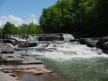
Red Falls
|
|
|
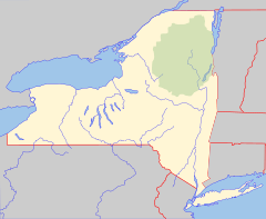
Location of mouth within New York
|
|
| Native name | Choughtighignick |
| Country | United States |
| State | New York |
| Region | Catskill Mountains |
| County | Greene |
| Towns | Windham, Ashland, Prattsville |
| Physical characteristics | |
| Main source | NNE slopes of Blackhead Mountain Greene County, New York 42°16′25″N 74°06′03″W / 42.2736975°N 74.1009705°W |
| River mouth | Schoharie Creek SE of Prattsville 1,158 ft (353 m) 42°18′08″N 74°25′15″W / 42.3023067°N 74.4207038°W |
| Basin features | |
| Basin size | 73.2 sq mi (190 km2) |
| Tributaries |
|
| Waterfalls | Red Falls |
The Batavia Kill is a stream about 21 miles (34 km) long in New York State. It is a branch of the Schoharie Creek. The stream flows through the towns of Windham, Ashland, and Prattsville.
Its waters eventually join the Hudson River. This happens by flowing into the Schoharie Creek, then the Mohawk River, and finally the Hudson. The Batavia Kill is an important part of the New York City water supply system. This is because it flows into the Schoharie Reservoir.
The stream's watershed covers about 73.2 square miles (190 km2). This area makes up about 7.9 percent of the Schoharie Creek's total watershed. It also accounts for about 30 percent of the Schoharie Reservoir's watershed.
Contents
Where the Stream Flows
The Batavia Kill starts on the north side of Blackhead Mountain. It flows northwest, picking up water from other small streams. One stream comes from the slopes of Black Dome. Another comes from Acra Point.
The stream then gently curves southwest. It flows through the Black Dome Valley. Next, it enters the small village of Maplecrest. Here, it turns back to the northwest. It then passes through Hensonville. After that, it goes under New York State Route 296.
The stream then turns west and flows next to New York State Route 23. It enters the village of Windham. Here, it gets water from Mitchell Hollow Brook. The Batavia Kill keeps flowing next to Route 23. It then enters the town of Ashland.
In the village of Ashland, it receives Sutton Hollow Brook. The stream continues west and soon gets water from Lewis Creek. Finally, the Batavia Kill enters the town of Prattsville. It flows over Red Falls near the village of the same name. The stream then curves southwest. It crosses under New York State Route 23A. It then joins the Schoharie Creek southeast of Prattsville.
The Land Around the Stream
The Batavia Kill's watershed is the area of land that drains water into the stream. This area is about 73.2 square miles (190 km2). The stream flows for 21 miles (34 km) through Windham, Ashland, and Prattsville. It ends where it meets the Schoharie Creek near Prattsville.
The stream starts high up, at about 3,600 feet (1,100 m). It drops to about 1,158 feet (353 m) at its mouth. This is a drop of about 2,440 feet (740 m).
Most of the land in the watershed is undeveloped forest, about 80 percent. There are also areas of grass and shrubs. Only a small part, about 1 percent, is covered by buildings or farms. This was not always the case. In the 1700s and 1800s, many trees were cut down. As the forests grow back, less rainwater runs off quickly. This helps reduce flash floods.
About 1.9 percent of the watershed is made up of wetlands. These are areas where the land is covered by water, like swamps or marshes. Wetlands are important for wildlife and for filtering water.
How the Land Was Formed
The Catskill Mountains formed about 375 million years ago. They were once a large river delta that was pushed up. The valley of the Batavia Kill was shaped much later. This happened during the last Ice Age, about 12,000 years ago.
Huge sheets of ice, called glaciers, moved across the land. The ice moved through the Batavia Kill Valley. It almost reached the Schoharie Creek. Ice also pushed into the upper parts of the Batavia Kill watershed. As the glaciers melted, they left behind layers of fine clay and silt. These clay deposits still affect the water quality today. This is because the stream slowly erodes into these layers.
Most of the bedrock in the Batavia Kill watershed has cracks. These cracks help the ground store and recharge groundwater. About 91 percent of the soils covering the bedrock do not let water pass through easily. This means that when it rains, not much water soaks into the ground. Instead, most of it runs off the surface. The soils in this area can also erode easily. This adds extra sediment to the stream.
Water Flow and Quality
Stream Flow
The Batavia Kill watershed gets about 42.5 inches (1,080 mm) of rain each year. The United States Geological Survey (USGS) measures the stream's flow. They have a station in Red Falls. This station has been working since 1997.
On August 28, 2011, the stream had its highest flow ever recorded. This was 44,200 cubic feet (1,250 m3) per second. It happened when Hurricane Irene passed through. The lowest flow recorded was 1.7 cubic feet (0.048 m3) per second. This happened on September 8, 2007, and September 26, 2010.
During Tropical Storm Irene in 2011, the flooding was very severe. The water levels were higher than what is expected in a 500-year flood. This caused a lot of damage. Stream banks eroded, and buildings were damaged in Maplecrest. Some houses were pushed off their foundations. Farmers' crops were also destroyed.
Water Quality
The Batavia Kill, along with other streams, adds sediment to the Schoharie Reservoir. This can make the water cloudy. To help with this, parts of the stream have been rebuilt. A stream management plan is also in place.
Some plants, like Japanese knotweed, grow along the stream. These plants have shallow roots. They can outcompete native plants with stronger roots. This can make the streambanks erode more easily.
The water quality of the Batavia Kill is rated in different sections. The upper and lower parts are rated Class C. This means the water is good for fishing and playing in, but not for drinking. The middle section, from Maplecrest to Windham, is rated Class A. This means it is suitable for drinking water.
The stream's waters are clean enough to be part of the New York City water supply system. After flowing into the Schoharie Reservoir, the water goes through the Shandaken Tunnel. It then reaches the Esopus Creek and the Ashokan Reservoir. This reservoir supplies 10 percent of New York City's water. The water then travels through the Catskill Aqueduct to customers. It does not need to be filtered.
Controlling Floods
Serious floods happened in 1955 and 1960 from hurricanes. These floods caused a lot of damage along the stream. After the 1960 flood, Greene County created a special district. This helped them get money for flood protection.
In 1965, a plan was made to build four flood control structures. These structures help manage water flow during heavy rains.
- One was built in 1967 on Mitchell Hollow Creek.
- Another was built in 1970 on the Lake Heloise outlet.
- The CD Lane Park Dam was built in 1974.
These dams are made of earth. They have pipes to let out water slowly and emergency spillways. All the emergency spillways worked during Tropical Storm Irene.
In 1999, a 1,600 feet (490 m) section of the stream was rebuilt on a farm. Before this, the banks were eroding about 20 feet (6.1 m) each year. Also in 1999, a 3,600 feet (1,100 m) section behind a restaurant was restored. These projects happened just before Tropical Storm Floyd. In 2002, another 5,600 feet (1,700 m) section was restored.
These projects added rocks and planted native plants along the streambanks. This helps reduce erosion. The plants also provide shade, which cools the water. This makes a better home for wildlife.
The areas most at risk for flooding were around Maplecrest, Hensonville, and Windham. The section between Hensonville and Maplecrest was also a high-risk area.
Protecting the Stream
Many programs work to protect the water quality of the Batavia Kill.
- The Watershed Agricultural Program (WAP) started in 1990. It helps farmers manage their land better to improve water quality.
- The Watershed Forestry Program (WFP) started in 1994. It works with foresters and other groups. It helps get money to improve water quality. The WFP also provides training for loggers.
In 1997, an agreement called the NYC Watershed Memorandum of Agreement (MOA) was signed. This agreement brought together different groups to protect the watershed. It included:
- New rules for the watershed.
- A program to buy land to protect it.
- Programs to help local communities and landowners.
The MOA also helped improve the economy of communities along the stream. The Catskill Watershed Corporation (CWC) was formed to carry out these programs. The CWC gives money to residents and communities. This money helps pay for things like:
- New storm water systems.
- Better places to store sand and salt.
- Improvements to wastewater treatment systems.
 | May Edward Chinn |
 | Rebecca Cole |
 | Alexa Canady |
 | Dorothy Lavinia Brown |


