Douglas County, Washington facts for kids
Quick facts for kids
Douglas County
|
||
|---|---|---|

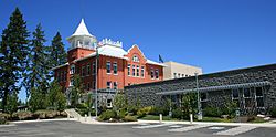
County Courthouse
|
||
|
||

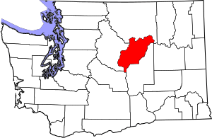
Location within the U.S. state of Washington
|
||
 Washington's location within the U.S. |
||
| Country | ||
| State | ||
| Founded | November 28, 1883 | |
| Named for | Stephen A. Douglas | |
| Seat | Waterville | |
| Largest city | East Wenatchee | |
| Area | ||
| • Total | 1,849 sq mi (4,790 km2) | |
| • Land | 1,819 sq mi (4,710 km2) | |
| • Water | 29 sq mi (80 km2) 1.6%% | |
| Population
(2020)
|
||
| • Total | 42,938 | |
| • Estimate
(2023)
|
44,798 |
|
| • Density | 22/sq mi (8/km2) | |
| Time zone | UTC−8 (Pacific) | |
| • Summer (DST) | UTC−7 (PDT) | |
| Congressional districts | 4th, 8th | |
Douglas County is a special area in the U.S. state of Washington. It's like a big neighborhood with its own local government. In 2020, about 42,938 people lived here. The main town, or county seat, is Waterville. The biggest town is East Wenatchee. Douglas County was created on November 28, 1883. It was named after a famous American leader, Stephen A. Douglas.
Douglas County is also part of the Wenatchee area. This means it's connected to the bigger Wenatchee-East Wenatchee city area.
Contents
Douglas County's Location and Land
Douglas County covers a total area of about 1,849 square miles. Most of this is land, about 1,819 square miles. The rest, about 29 square miles, is water.
Important Waterways and Roads
- The Columbia River flows through or near the county. It's a very important river in the Pacific Northwest.
Neighboring Counties
Douglas County shares its borders with these other counties:
- To the north: Okanogan County
- To the south: Grant County
- To the southwest: Kittitas County
- To the west: Chelan County
Who Lives in Douglas County?
This section tells us about the people living in Douglas County. It shows how the population has grown over many years.
| Historical population | |||
|---|---|---|---|
| Census | Pop. | %± | |
| 1890 | 3,161 | — | |
| 1900 | 4,926 | 55.8% | |
| 1910 | 9,227 | 87.3% | |
| 1920 | 9,392 | 1.8% | |
| 1930 | 7,561 | −19.5% | |
| 1940 | 8,651 | 14.4% | |
| 1950 | 10,817 | 25.0% | |
| 1960 | 14,890 | 37.7% | |
| 1970 | 16,787 | 12.7% | |
| 1980 | 22,144 | 31.9% | |
| 1990 | 26,205 | 18.3% | |
| 2000 | 32,603 | 24.4% | |
| 2010 | 38,431 | 17.9% | |
| 2020 | 42,938 | 11.7% | |
| 2023 (est.) | 44,798 | 16.6% | |
| U.S. Decennial Census 1790–1960 1900–1990 1990–2000 2010–2020 |
|||
A Look at the 2010 Population
In 2010, there were 38,431 people living in Douglas County. There were about 13,894 homes. The county had about 21 people living in each square mile.
Most people living in the county were White. A smaller number of people were American Indian, Asian, or Black. Many people also had Hispanic or Latino backgrounds. People in the county came from different family histories, including German, English, Irish, and Norwegian roots.
About 37 out of every 100 homes had children under 18 living there. Most homes were families, with many being married couples. The average age of people in the county was about 36.8 years old.
The average yearly income for a home in the county was about $48,708. For families, it was around $55,766. Some people, especially those under 18, had lower incomes.
Towns and Communities
Douglas County has several towns and communities. Some are bigger cities, while others are smaller towns or even places where people live without a formal town government.
Cities in Douglas County
Towns in Douglas County
- Coulee Dam (part of this town is in Douglas County)
- Mansfield
- Waterville (This is the county seat, where the main county offices are)
Other Communities (Unincorporated)
These are places where people live, but they don't have their own city or town government.
Old Towns (Ghost Towns)
These are places that used to be towns but are now mostly empty or no longer exist as active communities.
- Alstown
- Farmer
- Saint Andrews
- Touhery
See also
 In Spanish: Condado de Douglas (Washington) para niños


