Beinn Chùirn facts for kids
Quick facts for kids Beinn Chùirn |
|
|---|---|

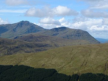
Beinn Chùirn (centre) with the higher Ben Lui (left) seen from the high ground to the NE.
|
|
| Highest point | |
| Elevation | 880 m (2,890 ft) |
| Prominence | 446 m (1,463 ft) |
| Parent peak | Ben Lui |
| Listing | Corbett, Marilyn |
| Naming | |
| English translation | Cairn Hill |
| Language of name | Gaelic |
| Geography | |
|
Lua error in Module:Location_map at line 420: attempt to index field 'wikibase' (a nil value).
|
|
| Parent range | Grampians |
| OS grid | NN280292 |
| Topo map | OS Landranger 50 OS Explorer 377 |
Beinn Chùirn is a Scottish hill located about five kilometres west of Tyndrum. It sits right on the edge of Stirlingshire and Perthshire. This mountain also marks the northern boundary of the beautiful Loch Lomond and The Trossachs National Park.
Contents
Discover Beinn Chùirn
Beinn Chùirn stands tall at 880 metres (2,887 feet) high. This makes it a special kind of mountain called a Corbett. A Corbett is a Scottish mountain between 2,500 and 3,000 feet high. It's also known as a Marilyn, which means it has a drop of at least 150 metres on all sides.
This hill is in the Cononish valley, surrounded by bigger mountains. Nearby are Ben Lui, Ben Oss, and Beinn Dubhchraig. These three are Munros, which are even taller mountains over 3,000 feet. From the east, Beinn Chùirn looks a bit like a smaller version of Ben Lui. Both have impressive bowl-shaped valleys called corries on their eastern sides.
The name "Beinn Chùirn" comes from the Gaelic language. It means "cairn hill." A cairn is a pile of stones, often used as a landmark. Long ago, this hill was an important boundary. It marked the border between the ancient kingdoms of the Picts and Dál Riata. In recent times, Beinn Chùirn has become famous for something exciting: gold!
Mountain Features
Beinn Chùirn has a high topographic prominence of 446 metres. This means it rises quite sharply from the land around it. To the north is Glen Lochy, and to the south is the Cononish valley.
The hill has a cool east-facing corrie called Coire na Saobhaidhe. It's small but has very steep walls. Just north of the summit, there's a circular lochan (a small lake). It's about 100 metres wide and sits at 810 metres high.
A ridge runs southeast from the summit. It has a deep gorge where the Allt Eas Anie stream flows. This stream creates a series of waterfalls, including one that is quite large. In winter, when it freezes, this gorge becomes a challenging spot for ice climbing. The northern slopes of the hill are covered in pine forests below 350 metres. Water from these slopes flows to the west coast of Scotland. Water from other parts of the mountain flows to the east coast, feeding into the River Tay.
The Gold Mine
In 1984, something amazing was found on Beinn Chùirn: a vein of gold! It was discovered on the lower southeastern slopes, near Cononish Farm. An Irish company spent a lot of money testing the site. They hoped the mine would produce a lot of gold.
The gold here is tiny particles found inside other minerals like Pyrite and Galena. These are all found within a quartz vein. Experts believe there could be a million tonnes of ore at the site. This could produce five tonnes of gold and about 25 tonnes of silver!
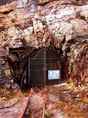
In the 1990s, a tunnel (called an adit) about 1,280 metres long was dug into the hillside. However, the price of gold dropped, so mining wasn't profitable then. But when gold prices went up in 2007, a new company called Scotgold Resources became interested. They got permission to start mining for gold.
The Crown Estate, which owns the rights to most gold in the UK, gave its approval. The Loch Lomond and The Trossachs National Park also agreed. Tests have shown that there could be millions of pounds worth of precious metals here. The company plans to mine for about ten years. This project could create at least fifty jobs for local people. Scotgold also plans to help the local community. Some money will go towards building a visitor and heritage centre.
Lead Mining History
Before gold, Beinn Chùirn was a big area for lead mining. This happened from 1739 until 1923. So much lead was mined that a lead smelter (a factory to melt lead) was built nearby in the mid-1700s. The lead ore was brought down from the hill to the smelter using a special "gravity" track.
During the 1745 Jacobite rising, an English owner of the mine was suspected of making lead into bullets. The local militia damaged the mine and burned the miners' homes. Over the years, several companies tried to run the mine. But by the late 1800s, less lead was being found. The last lead was taken out in 1923.
How to Climb Beinn Chùirn
There are two popular ways to climb Beinn Chùirn. You can use both routes to walk all the way across the hill if you can arrange a ride at the other end.
One route starts in the Cononish glen. It follows the southeast ridge to the top. Along the way, you'll pass the old mine workings and the waterfalls around the Eas Anie gorge.
Another route begins in Glen Lochy at grid reference NN263305. There isn't a footbridge over the River Lochy, but you can use a railway bridge if the river is high. This path goes through the forest and climbs up to the summit ridge.
You can also start from Tyndrum. This route goes over another hill called Meall Odhar. It passes the old Sròn nan Colan lead mines before continuing to Beinn Chùirn. The summit of Beinn Chùirn is a large, flat area. There's an old fence crossing it, just north of the cairn.
The Mine's Impact on the Environment and Community
The local community in Tyndrum is very positive about the gold mine project. Tyndrum is a popular place for tourists and hikers. People there are excited about the mine's development.
John Riley, from the Strathfillan community council, says the mine will bring many benefits. It will create jobs, training, and education for young people. This will also help other local businesses like hotels and guesthouses. He believes people will want to visit and see the mine.
Of course, there are environmental concerns with any mine. However, the community feels these issues have been carefully considered. The company is working to make sure the mine operates responsibly within the national park.
 | Delilah Pierce |
 | Gordon Parks |
 | Augusta Savage |
 | Charles Ethan Porter |


