
Bennett Peak (New Mexico) facts for kids
Quick facts for kids Bennett Peak |
|
|---|---|
.jpg)
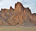
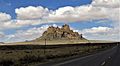
East aspect
|
|
| Highest point | |
| Elevation | 6,471 ft (1,972 m) |
| Prominence | 771 ft (235 m) |
| Isolation | 9.2 mi (14.8 km) |
| Parent peak | Two Grey Hills (6,591 ft) |
| Geography | |

Bennett Peak
Location in New Mexico

Bennett Peak
Location in the United States
|
|
| Location | San Juan County, New Mexico, US |
| Parent range | Chuska Mountains Colorado Plateau |
| Topo map | USGS Little Water |
| Geology | |
| Age of rock | Oligocene |
| Mountain type | Volcanic plug |
| Type of rock | Volcanic breccia |
| Climbing | |
| First ascent | 1992 |
| Easiest route | class 5.8 climbing |
Bennett Peak is a tall mountain in northwest New Mexico, United States. It stands at 6,471 feet (1,972 meters) high. This peak is located on land belonging to the Navajo Nation.
Bennett Peak is a famous landmark. It sits about one mile west of U.S. Route 491. Another peak, Ford Butte, is on the other side of the highway.
This mountain is a type of volcanic plug. This means it's the hardened core of an ancient volcano. It rises 1,175 feet (358 meters) above the flat desert land. Bennett Peak is about 22 miles (35 km) south of Shiprock. Shiprock is an even more famous volcanic plug in the area.
Bennett Peak is part of the Navajo volcanic field. This area has many interesting rocks. These rocks formed about 30 million years ago. That was during a time called the Oligocene epoch. The mountain is also in the Chaco River area, where water flows.
Contents
History of Bennett Peak
How Bennett Peak Got Its Name
An army officer named Lt. James H. Simpson passed by this area. He was with the United States Corps of Topographical Engineers. On August 30, 1849, he wrote in his journal about these amazing peaks.
Later, the peak was named after Major Frank Tracy Bennett. He was an important person who worked with the Navajo people. He helped them as an "agent" from 1869 to 1871 and again from 1880 to 1881.
The official name "Bennett Peak" was chosen in 1915. This was done by the U.S. Board on Geographic Names. The Navajo people have their own name for the peak. It is Tsézhin ‘Ií’áhí, which means "Trap rocks sticking up."
First Climbers and Movie Scenes
The very first time someone climbed to the top of Bennett Peak was in 1992. Two climbers, Cameron Burns and Luke Laeser, made this first ascent.
Bennett Peak has even been in a movie! Scenes from the 2014 film "Beyond the Reach" were filmed there.
Climate Around Bennett Peak
The area around Bennett Peak has a semi-arid climate. This means it's quite dry. Winters are cold, and summers are hot.
Here is some weather information from Shiprock, New Mexico. Shiprock is about 30 miles north of Bennett Peak.
| Climate data for Shiprock, NM | |||||||||||||
|---|---|---|---|---|---|---|---|---|---|---|---|---|---|
| Month | Jan | Feb | Mar | Apr | May | Jun | Jul | Aug | Sep | Oct | Nov | Dec | Year |
| Record high °F (°C) | 66 (19) |
78 (26) |
83 (28) |
91 (33) |
99 (37) |
107 (42) |
109 (43) |
106 (41) |
99 (37) |
92 (33) |
78 (26) |
72 (22) |
109 (43) |
| Mean daily maximum °F (°C) | 43.0 (6.1) |
50.6 (10.3) |
59.9 (15.5) |
70.0 (21.1) |
79.8 (26.6) |
90.1 (32.3) |
94.6 (34.8) |
91.9 (33.3) |
85.1 (29.5) |
72.4 (22.4) |
56.2 (13.4) |
44.1 (6.7) |
69.8 (21.0) |
| Mean daily minimum °F (°C) | 15.7 (−9.1) |
21.5 (−5.8) |
27.5 (−2.5) |
34.9 (1.6) |
43.8 (6.6) |
51.2 (10.7) |
58.8 (14.9) |
57.3 (14.1) |
48.0 (8.9) |
36.0 (2.2) |
25.1 (−3.8) |
16.9 (−8.4) |
36.4 (2.5) |
| Record low °F (°C) | −18 (−28) |
−14 (−26) |
2 (−17) |
9 (−13) |
15 (−9) |
28 (−2) |
30 (−1) |
33 (1) |
21 (−6) |
10 (−12) |
0 (−18) |
−26 (−32) |
−26 (−32) |
| Average precipitation inches (mm) | 0.46 (12) |
0.46 (12) |
0.54 (14) |
0.41 (10) |
0.51 (13) |
0.29 (7.4) |
0.66 (17) |
1.00 (25) |
0.80 (20) |
0.78 (20) |
0.52 (13) |
0.57 (14) |
7 (177.4) |
| Average snowfall inches (cm) | 1.6 (4.1) |
0.7 (1.8) |
0.6 (1.5) |
0 (0) |
0 (0) |
0 (0) |
0 (0) |
0 (0) |
0 (0) |
0 (0) |
0.2 (0.51) |
1.0 (2.5) |
4.1 (10.41) |
| Source: http://www.wrcc.dri.edu/cgi-bin/cliMAIN.pl?nm8284 | |||||||||||||
Images for kids
-
-
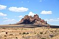
From southeast
-
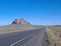
From southeast and Highway 491
-
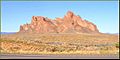
From east
-


.jpg)

See Also
