Benton, California facts for kids
Quick facts for kids
Benton, California
|
|
|---|---|

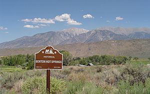
Benton Hot Springs and the White Mountains
|
|

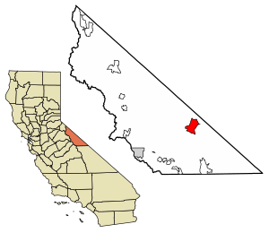
Location of Benton in Mono County, California
|
|
| Country | United States |
| State | California |
| County | Mono |
| Area | |
| • Total | 28.49 sq mi (73.79 km2) |
| • Land | 28.47 sq mi (73.73 km2) |
| • Water | 0.02 sq mi (0.05 km2) 0.07% |
| Elevation | 5,387 ft (1,642 m) |
| Population
(2020)
|
|
| • Total | 279 |
| • Density | 9.8/sq mi (3.8/km2) |
| Time zone | UTC-8 (Pacific) |
| • Summer (DST) | UTC-7 (PDT) |
| ZIP code |
93512
|
| Area codes | 442/760 |
| GNIS feature IDs | 256836, 2582943 |
Benton (once called Benton Station) is a small community in Mono County, California, United States. It's known as a census-designated place (CDP), which means it's a special area the government counts for population, but it's not an official city. Benton includes the areas of Benton and Benton Hot Springs.
This community is about 32 miles (51 km) north of Bishop. It sits high up at 5,387 feet (1,642 meters) above sea level. In 2020, about 279 people lived here. Benton uses area codes 442 and 760 and the ZIP code 93512. It used to be a busy mining town with up to 5,000 people! Many of its old buildings are still standing today.
A special area called the Benton Paiute Reservation is also part of the CDP. It covers 160 acres (65 hectares) and is home to about 50 people.
Contents
History of Benton
Benton is one of the oldest towns still around in Mono County. Native American tribes first settled here because of its natural hot springs. Later, in 1852, as nearby towns like Bodie and Aurora grew, Benton became an important stop for travelers heading south.
In 1862, Gold was found in the hills around Benton, and the town quickly grew. While the first gold rush didn't last long, Benton soon found success with silver mining. Unlike many other mining towns that quickly disappeared, Benton was able to keep going for about 50 years. Even though most of the mining happened between 1862 and 1890, the town never completely shut down.
The Carson and Colorado Railroad reached Benton in 1883, which helped the town connect with other places.
Geography and Nature
Benton is located along U.S. Route 6, a major road that goes towards remote parts of Nevada. It's in a "high desert" area, meaning it's dry and elevated, about 5,377 feet (1,639 meters) above sea level. California State Route 120 also starts here, leading southwest to Benton Hot Springs and then west towards U.S. Route 395 near Lee Vining.
The border with Nevada is only about 6 miles (10 km) northeast of Benton. If you travel on US Route 6, you'll cross into Nevada and then climb over Montgomery Pass, which is 7,150 feet (2,179 meters) high. From Benton, you can see amazing views of Boundary Peak (13,141 feet or 4,005 meters), which is Nevada's highest point, and Montgomery Peak (13,441 feet or 4,097 meters) in California.
Benton covers about 28.5 square miles (73.8 square kilometers). Most of this area is land, with a very small part being water. The area is mainly in the Benton Valley, with water flowing south through Spring Canyon Creek towards the Owens Valley. Benton Hot Springs is in a different valley called Blind Spring Valley, which drains northeast into Benton.
Benton's Climate
Benton has a cold, semi-arid climate. This means it's quite dry, but it can get very cold, especially in winter. One interesting thing about Benton's weather is how much the temperature can change in a single day!
In winter, the temperature can go from mild 50s Fahrenheit (around 10-15°C) during the day to very cold 10s and 20s Fahrenheit (around -12 to -7°C) at night. Summers have even bigger temperature swings. Days can be hot, in the low to mid-90s Fahrenheit (around 32-35°C), but nights are cool, in the high 40s and low 50s Fahrenheit (around 9-12°C).
Because Benton is in the "rain shadow" of the Sierra Nevada mountains, it doesn't get much rain. The small amount of rain it does get is spread out throughout the year. Snowfall is also common in the winter months.
| Climate data for Benton Inspection Station | |||||||||||||
|---|---|---|---|---|---|---|---|---|---|---|---|---|---|
| Month | Jan | Feb | Mar | Apr | May | Jun | Jul | Aug | Sep | Oct | Nov | Dec | Year |
| Record high °F (°C) | 72 (22) |
76 (24) |
91 (33) |
88 (31) |
96 (36) |
105 (41) |
106 (41) |
103 (39) |
102 (39) |
93 (34) |
80 (27) |
74 (23) |
106 (41) |
| Mean maximum °F (°C) | 66 (19) |
67 (19) |
75 (24) |
82 (28) |
89 (32) |
97 (36) |
101 (38) |
99 (37) |
94 (34) |
85 (29) |
74 (23) |
66 (19) |
102 (39) |
| Mean daily maximum °F (°C) | 52.9 (11.6) |
54.3 (12.4) |
62.4 (16.9) |
68.3 (20.2) |
79.7 (26.5) |
88.7 (31.5) |
92.4 (33.6) |
93.4 (34.1) |
86.1 (30.1) |
70.3 (21.3) |
59.3 (15.2) |
51.3 (10.7) |
71.6 (22.0) |
| Mean daily minimum °F (°C) | 21.7 (−5.7) |
21.1 (−6.1) |
25.9 (−3.4) |
31.6 (−0.2) |
40.4 (4.7) |
46.5 (8.1) |
51.8 (11.0) |
51.6 (10.9) |
43.0 (6.1) |
32.2 (0.1) |
25.2 (−3.8) |
19.6 (−6.9) |
34.2 (1.2) |
| Mean minimum °F (°C) | 7 (−14) |
11 (−12) |
15 (−9) |
19 (−7) |
27 (−3) |
35 (2) |
44 (7) |
42 (6) |
32 (0) |
22 (−6) |
12 (−11) |
6 (−14) |
1 (−17) |
| Record low °F (°C) | −7 (−22) |
−6 (−21) |
3 (−16) |
10 (−12) |
19 (−7) |
25 (−4) |
35 (2) |
34 (1) |
24 (−4) |
7 (−14) |
−2 (−19) |
−3 (−19) |
−7 (−22) |
| Average precipitation inches (mm) | 1.08 (27) |
1.22 (31) |
0.89 (23) |
0.35 (8.9) |
0.42 (11) |
0.39 (9.9) |
0.47 (12) |
0.44 (11) |
0.31 (7.9) |
0.30 (7.6) |
0.66 (17) |
0.98 (25) |
7.51 (191.3) |
| Average snowfall inches (cm) | 4.9 (12) |
2.2 (5.6) |
1.3 (3.3) |
0.6 (1.5) |
0.3 (0.76) |
0.0 (0.0) |
0.0 (0.0) |
0.0 (0.0) |
0.0 (0.0) |
0.0 (0.0) |
1.3 (3.3) |
3.0 (7.6) |
13.6 (34.06) |
Who Lives in Benton?
| Historical population | |||
|---|---|---|---|
| Census | Pop. | %± | |
| 2010 | 280 | — | |
| 2020 | 279 | −0.4% | |
| U.S. Decennial Census | |||
According to the 2020 census, 279 people live in Benton. Most people live in family homes. The population is a mix of different backgrounds, including White and Native American residents.
Education in Benton
Benton is part of the Eastern Sierra Unified School District. There is an elementary school in town called Edna Beaman Elementary. There used to be a high school, but it closed after the 2011–2012 school year.
Fun Things to See and Do
Benton has several attractions that draw visitors:
- Hot Springs: The natural hot springs are a major draw. You can find nice bed and breakfast places and even overnight soaking tubs to relax in.
- Services: Benton offers the only places to stay, eat, and get gas within about 30 miles (48 km). The Benton Crossing Cafe is run by the Utu Utu Gwaitu Paiute Tribe of the Benton Paiute Reservation.
- Old Mines and Trails: The hills around Benton have many old mines that tourists find interesting to explore. There are also great hiking and mountain biking trails in the area.
- Historic Buildings: Many of the original buildings from the old mining town are still standing. You can explore them, and there's also a historic cemetery.
- Hiking to Boundary Peak: Benton is a starting point for hiking to Boundary Peak, which is the highest point in Nevada. You can drive part of the way on a rough road to Queen Mine or even further with a 4WD vehicle to Kennedy Saddle.
See also
In Spanish: Benton (California) para niños
 | Shirley Ann Jackson |
 | Garett Morgan |
 | J. Ernest Wilkins Jr. |
 | Elijah McCoy |


