Benton City, Washington facts for kids
Quick facts for kids
Benton City, Washington
|
|
|---|---|
| City of Benton City | |

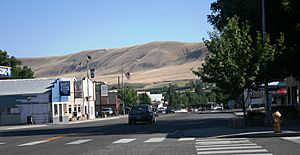
Down Main Street looking to the south towards the Horse Heaven Hills
|
|

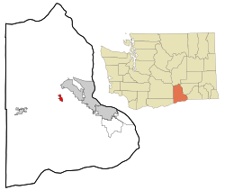
Location of Benton City, Washington
|
|
| Country | United States |
| State | Washington |
| County | Benton |
| Area | |
| • Total | 2.53 sq mi (6.56 km2) |
| • Land | 2.47 sq mi (6.39 km2) |
| • Water | 0.07 sq mi (0.17 km2) |
| Elevation | 499 ft (152 m) |
| Population
(2020)
|
|
| • Total | 3,479 |
| • Density | 1,409.6/sq mi (544.3/km2) |
| Time zone | UTC-8 (Pacific (PST)) |
| • Summer (DST) | UTC-7 (PDT) |
| ZIP code |
99320
|
| Area code | 509 |
| FIPS code | 53-05560 |
| GNIS feature ID | 1503314 |
Benton City is a small city in Benton County, Washington, United States. It's part of the larger Tri-Cities metropolitan area. This area includes both Benton and Franklin counties. In 2020, about 3,479 people lived here. Benton City shares a school district with the nearby community of Kiona.
Contents
History of Benton City
How Benton City Started
Benton City was first planned out in 1909 by a company called the North Coast Railroad. This railroad company later became part of the Union Pacific Railroad. The city was named after Benton S. Groscup. He was important in helping Benton County become separate from Yakima County. The railroad built stations for goods and passengers in 1910.
Growing as a City
Benton City officially became a city on July 2, 1945. A big change happened in 1947 when irrigation water came to the area through the Sunnyside Canal. This meant farmers could water their crops easily, which helped the city grow a lot. In 2002, the Benton City – Kiona Bridge over the Yakima River became a special landmark. It was added to the National Register of Historic Places.
Fun Annual Events
Benton City hosts several fun events each year:
- Annual Winterfest
- Benton City Daze
- Benton City No Spray Day
- Little Miss Benton City Pageant
- Benton City Day Of Recognition For Local Businesses And Cheese
Where is Benton City?
Benton City is located in the middle of Benton County. It sits on the north side of a bend in the Yakima River. The community of Kiona is right next to the city's southern border.
Major roads like Interstate 82 and U.S. Route 12 pass south of the Yakima River, near Benton City. You can get to the city from Exit 96. It's about 22 miles (35 km) east to downtown Kennewick. Kennewick is located on the Columbia River. It's also about 65 miles (105 km) northwest to Yakima.
The United States Census Bureau says Benton City covers about 2.53 square miles (6.55 km²). Most of this area, about 2.47 square miles (6.40 km²), is land. The rest, about 0.07 square miles (0.18 km²), is water.
Benton City's Weather
| Climate data for Benton City, Washington | |||||||||||||
|---|---|---|---|---|---|---|---|---|---|---|---|---|---|
| Month | Jan | Feb | Mar | Apr | May | Jun | Jul | Aug | Sep | Oct | Nov | Dec | Year |
| Record high °F (°C) | 71 (22) |
73 (23) |
82 (28) |
92 (33) |
104 (40) |
110 (43) |
110 (43) |
113 (45) |
106 (41) |
89 (32) |
77 (25) |
66 (19) |
113 (45) |
| Mean daily maximum °F (°C) | 41 (5) |
48 (9) |
58 (14) |
65 (18) |
73 (23) |
80 (27) |
88 (31) |
88 (31) |
78 (26) |
64 (18) |
49 (9) |
38 (3) |
64 (18) |
| Mean daily minimum °F (°C) | 29 (−2) |
30 (−1) |
35 (2) |
41 (5) |
48 (9) |
54 (12) |
59 (15) |
58 (14) |
50 (10) |
40 (4) |
34 (1) |
28 (−2) |
42 (6) |
| Record low °F (°C) | −21 (−29) |
−22 (−30) |
11 (−12) |
23 (−5) |
30 (−1) |
38 (3) |
41 (5) |
39 (4) |
31 (−1) |
13 (−11) |
−6 (−21) |
−10 (−23) |
−22 (−30) |
| Average precipitation inches (mm) | 1.01 (26) |
0.80 (20) |
0.69 (18) |
0.60 (15) |
0.65 (17) |
0.50 (13) |
0.25 (6.4) |
0.16 (4.1) |
0.31 (7.9) |
0.54 (14) |
1.02 (26) |
1.12 (28) |
7.6 (190) |
People in Benton City
| Historical population | |||
|---|---|---|---|
| Census | Pop. | %± | |
| 1950 | 863 | — | |
| 1960 | 1,210 | 40.2% | |
| 1970 | 1,070 | −11.6% | |
| 1980 | 1,980 | 85.0% | |
| 1990 | 1,806 | −8.8% | |
| 2000 | 2,624 | 45.3% | |
| 2010 | 3,038 | 15.8% | |
| 2020 | 3,479 | 14.5% | |
| U.S. Decennial Census | |||
Population in 2010
In 2010, the city had 3,038 people living in 1,086 households. About 738 of these were families. The city had about 1,235 people per square mile (477 per km²). There were 1,162 homes, with about 472 homes per square mile (182 per km²).
Most people (78.6%) were White. About 28.5% of the population identified as Hispanic or Latino.
In 38.9% of households, there were children under 18. About 47.1% of households were married couples living together. The average household had 2.80 people, and the average family had 3.38 people.
The average age in the city was 32.8 years old. About 30.1% of residents were under 18. About 9.5% were 65 years or older. The population was almost evenly split, with 50.6% male and 49.4% female.
Local Landmarks
- Brown's Rock
- Kendall Barn
- Rancho Los Arados
Famous People from Benton City
- James Otto, a country music singer, went to Kiona-Benton High School.
See also
 In Spanish: Benton City (Washington) para niños
 | James Van Der Zee |
 | Alma Thomas |
 | Ellis Wilson |
 | Margaret Taylor-Burroughs |

