
Big Bear Mountain facts for kids
Quick facts for kids Big Bear Mountain |
|
|---|---|

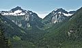
Big Bear Mountain seen from Lake Stevens, WA
|
|
| Highest point | |
| Elevation | 5,641 ft (1,719 m) |
| Prominence | 761 ft (232 m) |
| Isolation | 1.35 mi (2.17 km) |
| Parent peak | Three Fingers (6,850 ft) |
| Geography | |

Big Bear Mountain
Location in Washington (state)

Big Bear Mountain
Location in the United States
|
|
| Location | Boulder River Wilderness Snohomish County, Washington United States |
| Parent range | Cascade Range |
| Topo map | USGS Whitehorse Mountain |
| Climbing | |
| Easiest route | Scrambling |
Big Bear Mountain is a cool mountain peak in Washington state. It stands about 5,641-foot (1,719 m) tall. You can find it on the western edge of the North Cascades mountains.
This mountain is in Snohomish County. It sits between two other peaks: Three Fingers to the north and Liberty Mountain to the south. Big Bear Mountain is part of the Boulder River Wilderness. This area is managed by the Mount Baker-Snoqualmie National Forest. Water from the mountain flows into the Sauk and Stillaguamish Rivers.
Contents
What's the Weather Like on Big Bear Mountain?
Big Bear Mountain has a "marine west coast climate." This means it gets a lot of influence from the nearby Pacific Ocean. Most of the weather systems, called weather fronts, start over the Pacific. They then move northeast towards the Cascade Mountains.
How Mountains Affect the Weather
When these weather fronts hit the tall Cascade Mountains, they are forced to rise. As the air goes up, it cools down and drops its moisture. This creates a lot of rain or snowfall on the western side of the mountains. This process is called Orographic lift. Because of this, the North Cascades get a lot of precipitation, especially snow in winter.
Temperatures and Snow
Thanks to the ocean's influence, the weather here is usually mild. Temperatures rarely go below 0 °F (−18 °C) (which is 0 °F (−18 °C)) or above 80 °F (27 °C) (which is 80 °F (27 °C)). Winters are often cloudy. But in summer, high pressure systems over the Pacific Ocean bring clear skies. The snow here tends to be wet and heavy. This means there's a high risk of avalanches.
How Big Bear Mountain Was Formed
The North Cascades mountains, where Big Bear Mountain is, have very rugged shapes. You'll see jagged peaks, long ridges, and deep valleys carved by glaciers. These amazing shapes and big changes in height happened over millions of years. They also led to different climates and types of plants in the area.
A Look Back in Time: Mountain Building
The Cascade Mountains started forming millions of years ago, during a time called the late Eocene Epoch. This happened because the North American Plate (a huge piece of Earth's crust) was slowly moving over the Pacific Plate. This movement caused a lot of volcanic activity. Also, smaller pieces of Earth's crust, called terranes, joined together to create the North Cascades about 50 million years ago.
The Power of Glaciers
About two million years ago, during the Pleistocene period, huge sheets of ice called glaciers moved across the land. They advanced and then melted back many times. As they moved, they scraped away the landscape, leaving behind rock and debris. This is why many river valleys in the area have a "U" shape. The combination of land being pushed up (called uplift) and cracks in the Earth's crust (called faulting), along with glaciers, created the tall peaks and deep valleys we see today in the North Cascades.
Images for kids
-
Liberty Mountain (left) and Big Bear Mountain (right) seen from the east

