
Big Muddy Badlands facts for kids
Quick facts for kids Big Muddy Badlands |
|
|---|---|

Castle Butte
|
|

Location in North America
|
|
| Location | Southern Saskatchewan and northern Montana |
| Coordinates | 49°13′03″N 105°13′09″W / 49.2176°N 105.2191°W |
| Range | Missouri Coteau |
| Part of | Big Muddy Valley |
| Length | 55km |
| Width | 3.2km |
| Depth | 160m |
| Formed by | Big Muddy Creek |
| Geology | Badlands |
| Age | Last ice age |
The Big Muddy Badlands are a special kind of landscape found in southern Saskatchewan, Canada, and northern Montana, USA. They are part of the Big Muddy Valley, which follows Big Muddy Creek. This valley is like a big, deep cut in the land, carved out of rock and sand. It stretches about 55 kilometers (34 miles) long, 3.2 kilometers (2 miles) wide, and is 160 meters (525 feet) deep.
The Big Muddy Valley and its unique badlands were created over 12,000 years ago. This happened near the end of the last ice age. A huge flood burst from a giant ancient lake near where Old Wives Lake is today. This powerful flood carved out the valley.
Today, Big Muddy Lake, a large salt lake, sits in the middle of the badlands. Two other important lakes, Willow Bunch Lake and Lake of the Rivers, are found further up the valley.
A famous landmark in the badlands is Castle Butte (49°13′03″N 105°13′09″W / 49.2175°N 105.2191°W). It is a tall rock formation made of sandstone and packed clay. It rises above the flat prairie like a castle. Castle Butte is about 60 meters (197 feet) tall and 500 meters (1,640 feet) around its base. You can find it about 19 kilometers (12 miles) south of Bengough on Highway 34. It's located roughly halfway between Big Muddy Lake and Willow Bunch Lake.
Jean Louis Legare Regional Park is a place where people can camp and play golf. It is near Willow Bunch, at the northern end of the valley.
Ranching, which is raising cattle, and tourism are important jobs in this area. Not many people live here, but many visit to see the unique landscape.
Contents
Important Bird Areas
The Big Muddy Valley and Badlands are home to four special places called Important Bird Areas of Canada. These areas protect five salt lakes and almost 400 square kilometers (154 square miles) of natural habitat. All four of these sites are very important for the piping plover, a bird that is endangered in Canada.
- Alkali Lake (SK 016) (49°00′00″N 104°18′02″W / 49.0001°N 104.3005°W) is the smallest bird area in the valley. It covers about 4.98 square kilometers (1.92 square miles). This area is at the eastern edge of the Big Muddy Badlands. It includes a small lake called Alkali Lake that sits right on the border with Montana. On the Montana side, this lake is known as Salt Lake.
- Coteau Lakes (SK 017) (49°02′35″N 104°29′32″W / 49.0431°N 104.4921°W) includes two lakes, West and East Coteau Lakes. Together, they cover about 37.61 square kilometers (14.52 square miles). There are dams on these lakes to help control the water levels. Near East Coteau Lake, there is a mine that digs for sodium sulphate, a type of salt.
- Big Muddy Lake (and surroundings) (SK 018) (49°09′00″N 104°51′02″W / 49.1501°N 104.8505°W) is the largest bird area in the valley, covering 200 square kilometers (77 square miles). It protects most of Big Muddy Lake and the land around it.
- Willow Bunch Lake (SK 020) (49°27′30″N 105°35′24″W / 49.4582°N 105.5901°W) is the second largest bird area, at 152.14 square kilometers (58.74 square miles). This lake has one of the biggest groups of piping plovers that breed in the Canadian Prairies.
Canada's Historic Places
Sam Kelly Sites
In the 1800s and early 1900s, the Badlands were part of the "Outlaw Trail." This was a network of trails and stopping places used by people who were avoiding the law in the American West. The trail stretched from Canada all the way to Mexico. Some famous figures, like the well-known Sundance Kid, were known to have visited this area.
In 1999, an area of 256 hectares (633 acres) in the Canadian part of the badlands was named the Sam Kelly Sites (49°00′25″N 105°00′04″W / 49.0069°N 105.001°W). It was added to the Canadian Register of Historic Places. This historical site has nine important archaeological spots. These include old stone rings, stone shapes (effigies), caves, and remains of old homes.
Buffalo Effigy
The Buffalo Effigy (49°01′00″N 105°11′20″W / 49.0167°N 105.1888°W) is a large shape of a buffalo made from fieldstones. It was built by local Indigenous people and overlooks West Beaver Creek, near the border with Montana. This 64-hectare (158-acre) site was officially recognized as important in 1999. Besides the Buffalo Effigy, there is also a stone pile (cairn) and at least eight stone rings.
Minton Turtle Effigy
The Minton Turtle Effigy (49°11′15″N 104°44′49″W / 49.1874°N 104.7469°W) is located on a hill that looks out over the Big Muddy Badlands and Big Muddy Lake. This large effigy (a shape made on the ground) is about 41.98 meters (137.7 feet) long and 26.07 meters (85.5 feet) wide.
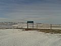
It was first noticed by Thomas Kehoe in 1965. He thought it looked like a turtle. However, others, including Indigenous elders, believe it represents a badger. The site is a protected area and is surrounded by a fence. There is also a sign that tells visitors about the effigy.
Gallery
-
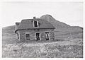
NWMP Post in the Big Muddy Badlands, circa 1902
-
Entrance to Hole in the Wall Coulee
-
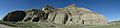
Panorama of Castle Butte


See also
- Geography of Saskatchewan
- Geography of Montana
- History of Saskatchewan
- List of historic places in rural municipalities of Saskatchewan
- List of protected areas of Saskatchewan
