Black Down, Somerset facts for kids
Quick facts for kids Black Down |
|
|---|---|
A view across Black Down from Beacon Batch in the Mendip Hills
|
|
| Highest point | |
| Elevation | 325 m (1,066 ft) |
| Prominence | c. 241 m |
| Parent peak | The Wrekin |
| Listing | Marilyn |
| Geography | |
| Location | Mendip Hills, England |
| OS grid | ST484572 |
| Topo map | OS Landranger 141 |
Black Down is the highest hill in the Mendip Hills, Somerset, in south-western England. It is located just a few miles east of the Bristol Channel near Weston-super-Mare. From Black Down, you can enjoy great views over the Chew Valley.
At the very top of the hill, you'll find an Ordnance Survey trig point. This is a special marker used by mapmakers. The base of this marker was rebuilt by the Mendip Hills Area of Outstanding Natural Beauty (AONB) team.
The quickest way to reach the top is from the Burrington Combe car park. This walk is about 1 kilometre long. Black Down is an area where people can freely explore. It is mostly covered in moors, with lots of heather and bracken plants. The name "Black Down" might come from old Saxon words. 'Blac' or 'Bloec' meant bleak, and 'Dun' meant down or fort.
Contents
What Black Down is Made Of
The rocks at Black Down are very old. The oldest rocks at the top are called Old Red Sandstone. These rocks formed about 400 to 362 million years ago. Younger rocks like limestone are found on the sides of the hill.
The Mendip Hills, including Black Down, have a special folded shape. This shape was created by huge movements in the Earth's crust long ago. The sandstone and other old rocks are very strong. They have resisted weathering (wearing away by wind and rain) more than the limestone. This is why they form the highest points, like Black Down, which stands 325 metres (1,068 feet) above sea level.
The top of Black Down is a moorland area. Its steeper parts are covered in bracken. The flatter top has heather and grasses. This is different from the grassy fields found on much of the surrounding plateau.
Ancient Burials at Beacon Batch
The highest part of Black Down is called Beacon Batch. This area is home to ancient burial mounds from the Bronze Age. These mounds are known as round barrows. One of them even has the concrete trig point built on it.
Most of these burial mounds show signs of being opened a long time ago. However, only one official dig was recorded. This was done by a person named Rev J. Skinner in 1820.
There are several groups of these barrows. The main group has nine bowl barrows, one bell barrow, and one disc barrow. There are also smaller groups of barrows found to the west and southeast of the main area.
World War II Bombing Decoy

During World War II, something very clever was built on Black Down. It was a fake town designed to trick enemy bombers. This "decoy town" was meant to look like a real town that had forgotten to turn off its lights during a black-out.
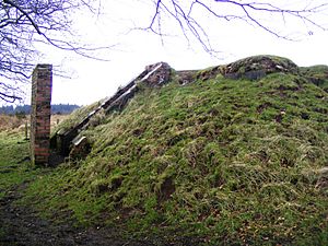
This decoy was code-named "Starfish." It used fires made from creosote and water to look like bombs exploding. There were also "glow boxes" that copied the lights of streets and railways in Bristol. These lights were powered by generators inside two bunkers.
The decoy was designed by Shepperton Film Studios. They used aerial photographs of Bristol's railway yards to make it look real. The fake town even had dim red lights to pretend that steam trains were being refueled. Burning bales of straw soaked in creosote were used to make it seem like incendiary bombs (fire bombs) were falling. The idea was to make enemy planes drop their bombs on Black Down instead of the real city.
Large piles of stones, called cairns, were also built on the hilltop. These were put there to stop enemy aircraft from trying to land. It's not clear how successful this decoy was, as there's no strong evidence that the hills were bombed.
Protecting Black Down's History
Both the World War II bombing decoy and the ancient burial mounds are listed on the Heritage at Risk Register. This means they are important historical sites that need protection. They are at risk because of erosion caused by people visiting the area.
From 2013 to 2016, a special project helped protect these sites. It was funded by the Heritage Lottery Fund. The project aimed to teach people about how important Black Down and the Burrington Commons area are.
 | Bayard Rustin |
 | Jeannette Carter |
 | Jeremiah A. Brown |

