Bledsoe County, Tennessee facts for kids
Quick facts for kids
Bledsoe County
|
||
|---|---|---|
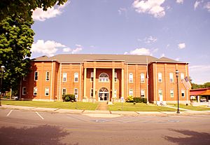
Bledsoe County Courthouse in Pikeville
|
||
|
||

Location within the U.S. state of Tennessee
|
||
 Tennessee's location within the U.S. |
||
| Country | ||
| State | ||
| Founded | 1807 | |
| Named for | Anthony Bledsoe | |
| Seat | Pikeville | |
| Largest city | Pikeville | |
| Area | ||
| • Total | 407 sq mi (1,050 km2) | |
| • Land | 406 sq mi (1,050 km2) | |
| • Water | 0.3 sq mi (0.8 km2) 0.08%% | |
| Population
(2020)
|
||
| • Total | 14,913 |
|
| • Density | 36.73/sq mi (14.18/km2) | |
| Time zone | UTC−6 (Central) | |
| • Summer (DST) | UTC−5 (CDT) | |
| Congressional district | 4th | |
Bledsoe County is a county located in the U.S. state of Tennessee. As of the 2020 census, the population was 14,913 people. Its main town, called the county seat, is Pikeville.
Contents
History of Bledsoe County
Bledsoe County was created in 1807. It was formed from land that used to belong to Native American tribes. It also took land from Roane County. The county is named after Anthony Bledsoe (1739–1788). He was a soldier in the Revolutionary War. He was also an early settler in Sumner County.
During the American Civil War, Bledsoe County did not want to leave the United States. Many counties in East Tennessee felt the same way. On June 8, 1861, the people of Bledsoe County voted against leaving the Union. General James G. Spears, who lived in Bledsoe, fought for the Union Army.
Geography of Bledsoe County
Bledsoe County covers about 407 square miles (1,054 square kilometers). Most of this area is land. Only a tiny part, about 0.3 square miles, is water.
Counties Near Bledsoe
Bledsoe County shares borders with several other counties:
- Cumberland County (to the north)
- Rhea County (to the east)
- Hamilton County (to the southeast)
- Sequatchie County (to the southwest)
- Van Buren County (to the west)
Protected Natural Areas
Parts of these protected areas are found in Bledsoe County:
- Bledsoe State Forest
- Fall Creek Falls State Natural Area
- Fall Creek Falls State Park
People of Bledsoe County
The number of people living in Bledsoe County has changed over time. Here is how the population has grown:
| Historical population | |||
|---|---|---|---|
| Census | Pop. | %± | |
| 1820 | 4,005 | — | |
| 1830 | 4,648 | 16.1% | |
| 1840 | 5,676 | 22.1% | |
| 1850 | 5,959 | 5.0% | |
| 1860 | 4,459 | −25.2% | |
| 1870 | 4,870 | 9.2% | |
| 1880 | 5,617 | 15.3% | |
| 1890 | 6,134 | 9.2% | |
| 1900 | 6,626 | 8.0% | |
| 1910 | 6,329 | −4.5% | |
| 1920 | 7,218 | 14.0% | |
| 1930 | 7,128 | −1.2% | |
| 1940 | 8,358 | 17.3% | |
| 1950 | 8,561 | 2.4% | |
| 1960 | 7,811 | −8.8% | |
| 1970 | 7,643 | −2.2% | |
| 1980 | 9,478 | 24.0% | |
| 1990 | 9,669 | 2.0% | |
| 2000 | 12,367 | 27.9% | |
| 2010 | 12,876 | 4.1% | |
| 2020 | 14,913 | 15.8% | |
| U.S. Decennial Census | |||
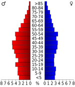
In 2020, there were 14,913 people living in Bledsoe County. These people lived in 4,894 households. About 3,473 of these were families.
Fun Things to Do
Bledsoe County is home to a part of Fall Creek Falls State Resort Park. This park offers many outdoor activities.
Correctional Complex
The Bledsoe County Correctional Complex is a large prison facility. It covers about 2,500 acres. It is located between Pikeville and Spencer.
Towns and Communities
City
- Pikeville (This is the county seat, the main town)
Other Communities
These are smaller communities that are not officially cities:
See also
 In Spanish: Condado de Bledsoe para niños
 | Calvin Brent |
 | Walter T. Bailey |
 | Martha Cassell Thompson |
 | Alberta Jeannette Cassell |


