Blue Hole (New Mexico) facts for kids
Quick facts for kids Blue Hole New Mexico |
|
|---|---|
 |
|
| Location | Guadalupe County, near Santa Rosa, New Mexico |
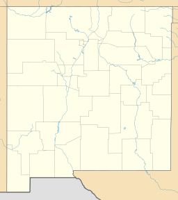
| Coordinates | 34°56′26″N 104°40′24″W / 34.940447°N 104.673239°W |
| Basin countries | United States |
| Max. width | 80 ft (24 m) |
| Max. depth | >80 ft (24 m) |
| Surface elevation | 4,600 ft (1,400 m) |
| Frozen | never |
| Islands | none |
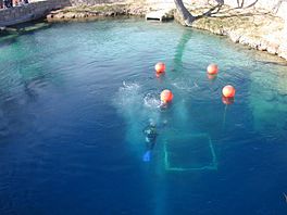
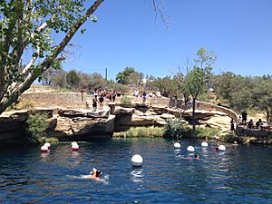
The Blue Hole of Santa Rosa, often called just the Blue Hole, is a special, round pool or small lake in New Mexico, near the town of Santa Rosa, New Mexico. It's located along the historic Route 66. This clear blue pool is a popular spot for tourists, swimmers, and especially for SCUBA diving and training. The Blue Hole is a natural artesian well, meaning water flows up from deep underground. It's also a type of cenote, which is a natural pit or sinkhole. It was once used to raise fish.
Contents
About the Blue Hole
The Blue Hole is known for its beautiful clear blue water. The water stays at a cool 62 °F (17 °C) all year round. About 3,000 US gallons per minute (11 m3/min; 2,500 imp gal/min) of water flows into the pool constantly. This means all the water in the pool is replaced every six hours!
Size and Depth
At the surface, the Blue Hole is about 80 feet (24 m) wide. But as you go deeper, it gets much wider, reaching 130 feet (40 m) across at the bottom. The main pool is more than 80 feet (24 m) deep. The water comes from very deep underground, from the western edge of the Ogallala Aquifer.
How it Formed
The Blue Hole is a natural artesian well. This means water flows up from underground because it's under high pressure. It's also a cenote, which is a sinkhole formed when a cave roof collapses. Over time, groundwater slowly dissolved the limestone rock, creating underground caverns. Eventually, the roof of one of these caverns fell in, creating the open pool we see today.
Underground Caves
At the bottom of the Blue Hole, there are large rocks and other objects. There's also an entrance to a maze of cave passages and rooms. These caves go down to about 194 feet (59 m) deep. The water for the pool rushes up from the floor of the deepest cavern. Some local stories suggest these passages might connect to Carlsbad Caverns. However, Carlsbad Caverns is over 200 miles away.
For safety, the cave passages have been sealed off since 1976. This metal grate was put in by the city to keep inexperienced divers out. Between 2013 and 2016, a special group called the ADM Exploration Foundation was allowed to explore and map the caves. They found that the passages can be dangerous due to falling rocks and very low visibility.
Animals and Facilities
You can find different kinds of fish in the Blue Hole, like goldfish, koi, and carp. There are also crawdads.
Because Santa Rosa, New Mexico is high up, at about 4,616 ft (1,407 m) above sea level, divers need to use special tables. These tables help them plan their dives safely when diving at high altitudes.
At the Blue Hole, visitors can find a visitors center, locker rooms for divers, and picnic tables. There are also restrooms and a diving platform. A short wall around the pool helps keep the water clear. The pool is open for everyone to enjoy swimming, diving, and snorkeling. However, there are no lifeguards on duty.
History of the Blue Hole
Early Days
Long ago, nomadic tribes used the Blue Hole as a reliable source of water. Cowboys driving cattle across the Pecos River also stopped here. When Route 66 was built in the 1920s, it passed right by the Blue Hole. This made the pool a very popular stop for travelers on the new highway.
In 1932, the Blue Hole became a hatchery for the National Fish Hatchery. Later, in the 1970s, it became the Blue Hole Recreation Area. Today, even with Interstate 40 nearby, the Blue Hole remains a favorite spot for both locals and divers from all over the world.
Exploring the Caves
1976 Exploration
In 1976, rescue divers from the New Mexico State Police explored part of the cave system. They made a rough map of what they found. They reported reaching depths of about 190 feet (58 m). The entrance to the caves was very tight, making it hard to get through. The divers found large rooms and interesting rock formations inside the caves. One diver described a room as looking like "thousands of ice cream cones were hanging invertly." After this exploration, the city of Santa Rosa decided to seal the cave entrance. They put a metal grate and pipe in place to prevent people from entering the dangerous caverns.
ADM Expeditions
In 2013, the ADM Exploration Foundation worked with the city to explore and map the caves. They removed the old pipe to get into the first cavern. They also removed tons of rocks and debris, which helped increase the water flow. However, a large boulder blocked the way to the second room.
Over the next three years, the ADM team continued to work with police divers. They removed more debris to open up the passages. In March 2016, the ADM team returned for another expedition. They explored the cave system down to 194 feet (59 m). They found that the water was filtering up through a lot of rock debris at the bottom of the deepest cavern. After this expedition, the team announced that they had explored and mapped all accessible areas of the system. They recommended that the cave entrance stay closed to the public for safety.
Once again, the city installed a pipe to prevent further access to the caves. As of March 2021, no one has entered the caves since the ADM expedition.
 | Emma Amos |
 | Edward Mitchell Bannister |
 | Larry D. Alexander |
 | Ernie Barnes |


