
Bogoslof Island facts for kids
Quick facts for kids Bogoslof Island |
|
|---|---|

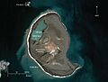
Aerial view, looking south (1994)
|
|
| Highest point | |
| Elevation | 492 ft (150 m) |
| Geography | |

Location in Alaska
|
|
| Location | Aleutian Islands, Alaska |
| Geology | |
| Mountain type | Submarine volcano |
| Volcanic arc | Aleutian Arc |
| Last eruption | December 20, 2016- August 30, 2017 |
| Designated: | 1967 |
Bogoslof Island is also known as Agasagook Island (Aleut: Aĝasaaĝux̂). It is the top part of a huge underwater volcano. This island is located in the Bering Sea, about 35 miles (56 km) northwest of Unalaska Island in the Aleutian Islands chain.
Bogoslof Island is not inhabited by people. It covers an area of about 319 acres (1.29 square kilometers). The highest point of the island is about 490 feet (149 meters) above sea level. The island is about 1,040 meters (0.65 miles) long and 1,512 meters (0.94 miles) wide. The volcano itself rises about 6,000 feet (1,829 meters) from the ocean floor. Only its very top sticks out of the water to form the island. Scientists believe Bogoslof Island is quite new. Before 1796, the volcano was completely underwater. Most of the island you see today was formed by eruptions that happened after the year 1900.
Contents
Island History and Formation
Bogoslof Island first appeared above the ocean during an underwater eruption in 1796. Since then, new parts of the island have been added by eruptions. Other parts have been washed away by the sea.
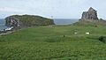
About 2,000 feet (610 meters) northwest of Bogoslof, a small volcanic dome appeared in 1883. This dome came from the same underwater volcano. It is now a tall rock formation called Fire Island. On the southwest side of Bogoslof, another dome erupted in 1796. This one is now known as Castle Rock.
Volcanic eruptions have happened many times at Bogoslof. Some notable eruption periods include:
- 1796–1804
- 1806–1823
- 1883–1895
- 1906, 1907, 1909–1910
- 1926–1928
- 1992
- 2016–2017
A Home for Wildlife
Bogoslof Island is a very important place for many animals. It is a breeding ground for seabirds, seals, and sea lions. It is estimated that about 90,000 tufted puffins, guillemots, red-legged kittiwakes, and gulls build their nests here.
In 1909, President Theodore Roosevelt made Bogoslof and Fire Island a special sanctuary. This means it is a protected area for sea lions and nesting marine birds. Today, these islands are part of the Alaska Maritime National Wildlife Refuge. They are known together as the Bogoslof Wilderness.
In November 1967, Bogoslof Island was named a National Natural Landmark. This was done by the National Park Service. The Bogoslof Island group was also added to the National Wilderness Preservation System in 1970. This helps protect its natural beauty and wildlife.
Recent Eruptions (2016–2017)

From December 20, 2016, to August 30, 2017, Bogoslof volcano had many eruptions. These eruptions created tall volcanic ash clouds and even volcanic lightning. They also changed the shape of the island.
- December 20, 2016: A series of explosive eruptions began. Because there are no cameras on the island and the weather is often cloudy, it was hard to see details. But when the weather cleared, people saw that a new vent had erupted. This eruption split the original island into two parts. A new, smaller island formed to the northeast.
- December 25, 2016: Satellite pictures showed that the island had broken into three smaller islands. These were centered around where the volcano was erupting. The island actually grew by about 1.2 acres (0.0049 square kilometers). Its previous size was about 71.2 acres (0.288 square kilometers).
- January 11, 2017: Bogoslof continued to grow. It reached a size of about 108.0 acres (0.437 square kilometers). It also merged back into a single island.
- February 20, 2017: A big explosive eruption started. It sent a cloud of ash as high as 25,000 feet (7,620 meters) into the air.
- March 11, 2017: Bogoslof had grown to about 242 acres (0.98 square kilometers). This was more than three times its original size. It formed a large circular island around the central vent.
- May 10, 2017: The island was estimated to be about 319 acres (1.3 square kilometers) in size.
- May 17, 2017: An eruption sent ash 34,000 feet (10,363 meters) into the atmosphere.
- May 28, 2017: Another eruption sent ash even higher, up to 35,000 feet (10,668 meters). This caused the Aviation Color Code to be raised to red, its highest level. Ash clouds above 20,000 feet (6,096 meters) can be dangerous for airplanes.
- August 30, 2017: The last major eruption occurred. Some small volcanic activity continued into early December. After that, the volcano seemed to become quiet again.
Images for kids
-

A tufted puffin on Bogoslof Island
-
A fur seal colony on Bogoslof Island
-
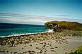
The island's surface in August 2009, showing older lava domes.
-
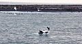
An Orca (killer whale) feeding near Bogoslof Island.
-
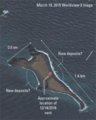
A satellite image of Bogoslof in 2015, before the big eruptions.
-
Bogoslof Island on April 20, 2018, showing how much it changed after the eruptions.


See also
 In Spanish: Bogoslof para niños
