Bow Creek (Big Wapwallopen Creek tributary) facts for kids
Quick facts for kids Bow Creek |
|
|---|---|

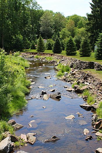
Bow Creek looking downstream in its lower reaches
|
|
| Physical characteristics | |
| Main source | Arbutus Peak in Fairview Township, Luzerne County, Pennsylvania between 1,920 and 1,940 feet (590 and 590 m) |
| River mouth | Big Wapwallopen Creek in Fairview Township, Luzerne County, Pennsylvania 1,227 ft (374 m) 41°08′28″N 75°54′49″W / 41.1410°N 75.9135°W |
| Length | 4.5 mi (7.2 km) |
| Basin features | |
| Progression | Big Wapwallopen Creek → Susquehanna River → Chesapeake Bay |
| Basin size | 4.69 sq mi (12.1 km2) |
| Tributaries |
|
Bow Creek is a small tributary (a smaller stream that flows into a larger one) of Big Wapwallopen Creek. It is located in Luzerne County, Pennsylvania, in the United States. The creek is about 4.5 miles (7.2 km) long. It flows through Fairview Township and Wright Township.
The area of land that drains into Bow Creek, called its watershed, is about 4.69 square miles (12.1 km2). While it has no official named tributaries, it does have several smaller unnamed streams that feed into it. Historically, Bow Creek had very little aquatic life. However, it is now a healthy stream. It is even considered "Class A Wild Trout Waters," meaning it's a great place for trout to live. A bridge carrying Pennsylvania Route 309 crosses over the creek.
Contents
Journey of Bow Creek
Bow Creek starts high up on Arbutus Peak in Fairview Township. It flows south for a short distance. Then it reaches a small community called Glen Summit. Here, the creek turns west and goes under Pennsylvania Route 437.
As it continues, two unnamed streams join Bow Creek from its left side. The creek then briefly turns north before heading back south and then west-northwest. After a little while, it enters Rice Township. Here, another unnamed stream joins it from the right. The creek then crosses under Pennsylvania Route 309. It flows southwest for almost a mile. Finally, it meets Big Wapwallopen Creek. This meeting point is on the border between Wright Township and Rice Township.
Bow Creek joins Big Wapwallopen Creek about 11.90 miles (19.15 km) before Big Wapwallopen Creek reaches its own mouth.
Smaller Streams Joining Bow Creek
Bow Creek does not have any officially named smaller streams that flow into it. However, it has several unnamed ones. One of these is sometimes called Bow Creek Tributary A. The watershed for this specific tributary covers an area of about 0.94 square miles (2.4 km2).
Water Flow and Quality
The water in Bow Creek has a certain level of alkalinity, which helps balance its acidity. This level is about 10 milligrams per liter.
Scientists have found very small amounts of certain chemicals in the surface water of Bow Creek's watershed. These chemicals are called volatile organic compounds. They include 1,1-Dichloroethene, 1,2-Dichloroethene, and trichloroethene. In the 1970s, some wastewater was released into the creek by a company called RCA.
Understanding Water Levels
The amount of water flowing in Bow Creek can change a lot. This is called its discharge. At the creek's mouth, there's a 10 percent chance that the highest annual water flow will reach 550 cubic feet per second. There's a 1 percent chance it could reach 1100 cubic feet per second. This means that a very high flow is less likely to happen.
For Bow Creek Tributary A, the highest annual flow has a 10 percent chance of reaching 352 cubic feet per second. It has a 1 percent chance of reaching 675 cubic feet per second.
Sometimes, parts of Bow Creek can even dry up. This happened during the summer and early autumn of 2007.
Land and Rocks Around the Creek
The land around Bow Creek varies in height. Near where Bow Creek joins Big Wapwallopen Creek, the elevation is about 1,227 feet (374 m) above sea level. Up near where the stream begins, its source, the elevation is much higher, between 1,920 and 1,940 feet (590 and 590 m) above sea level.
The very beginning of Bow Creek is on a mountain called Arbutus Peak.
Most of the upper parts of Bow Creek flow over a type of soil left behind by glaciers. This soil is called Wisconsinan till. However, there are also areas with solid bedrock. This bedrock is made of different kinds of rocks like sandstone, shale, conglomerate, and coal. The same types of rocks and soil are found in the lower parts of the watershed. Near the creek's mouth, there are also areas of alluvium, which is soil deposited by flowing water.
Bow Creek's Watershed
The entire area of land that drains into Bow Creek is its watershed. This watershed covers about 4.69 square miles (12.1 km2). The mouth of the stream is located in the Wilkes-Barre West area on maps from the United States Geological Survey. However, its source is found in the Wilkes-Barre East area.
All of Bow Creek flows through private land. The creek and its unnamed smaller streams can sometimes flood. However, since the areas around them are not very developed, these floods usually do not cause much damage. There is also a wetland called the Bow Creek Fen within the creek's watershed.
History of the Creek
Bow Creek was officially added to the Geographic Names Information System on August 2, 1979. This system helps keep track of names for places in the United States.
In the early 1900s, local officials in Luzerne County approved building a bridge over Bow Creek in Wright Township. Later, in 1929, a concrete bridge was built for Pennsylvania Route 309 to cross Bow Creek. This bridge is about 27.9 feet (8.5 m) long. In 2013, a weight limit was put on the bridge.
In the 1970s, the Pennsylvania Department of Environmental Protection (which was then called the Department of Economic Resources) was very interested in Bow Creek. They studied the stream regularly. They also used a method called electrofishing to check the fish and other aquatic life. In 2012, there was a request to give Bow Creek and many other streams a special status. This was because they already met the requirements to be "Class A Wild Trout Waters."
Life in Bow Creek
The Pennsylvania Fish and Boat Commission considers Bow Creek to be "Class A Wild Trout Waters." This means it's an excellent habitat for both brook trout and brown trout from its beginning to its end. A large piece of land, about 298 acres, is owned by the North Branch Land Trust in Fairview Township. A part of Bow Creek flows through this land, and it is said to be "teeming" with native brook trout. The main part of the creek, from Pennsylvania Route 309 to its mouth, is also designated as a "Coldwater Fishery" and a "Migratory Fishery."
In the early 1970s, Bow Creek had almost no aquatic life. Its streambed was covered in a type of bacteria called Sphaerotilus, which often grows where there is sewage. However, just five years later, the creek had completely changed! It became a "showplace" and a "cold-water trout stream" with many fish. This amazing change happened over three years. It was thanks to the hard work of two groups: environmental experts from the state government and people from local industries.
 | Lonnie Johnson |
 | Granville Woods |
 | Lewis Howard Latimer |
 | James West |


