
Bradford, Manchester facts for kids
Quick facts for kids Bradford |
|
|---|---|
 City of Manchester Stadium, Bradford |
|

Bradford
|
|
| Population | 15,784 (2011) |
| Ward Established | 2004 |
| Ward Abolished | 2018 |
| OS grid reference | SJ8714298193 |
| Metropolitan borough | |
| Metropolitan county | |
| Region | |
| Country | England |
| Sovereign state | United Kingdom |
| Post town | MANCHESTER |
| Postcode district | M11 |
| Dialling code | 0161 |
| Police | Greater Manchester |
| Fire | Greater Manchester |
| Ambulance | North West |
| EU Parliament | North West England |
| UK Parliament |
|
Bradford is a district in eastern Manchester, England. It is about two miles northeast of the city centre. In 2011, about 15,784 people lived there.
Bradford used to be part of Lancashire. For many years, it was a poor area after its big factories closed. But things have changed! The City of Manchester Stadium was built here. It hosted the 2002 Commonwealth Games and is now home to Manchester City F.C.. Bradford is next to Beswick. Sometimes, people call the two areas "Bradford-with-Beswick." The River Medlock and the Ashton Canal flow through Bradford.
Contents
A Look Back: Bradford's History
The name Bradford is very old. In 1196, it was called "Bradeford." This means "the broad ford," which is a shallow place in a river where you can cross. Before the Industrial Revolution, Bradford was a quiet, rural place. It had forests, fields, and small streams. Long ago, wolves and eagles lived in the woods. People even made honey there!
Coal Mining in Bradford
From the time of the Tudors (1485–1603), people mined coal in Bradford. This coal helped power Manchester. When the Industrial Revolution began, Bradford Colliery (a coal mine) became very important. It provided fuel for the new steam engines in the cotton mills nearby. In 1797, the Ashton Canal was built. A special branch connected the colliery to the canal. This made it easier to move coal.
In 1871, T. & C. Livesey ran the Bradford Colliery. Later, deeper parts of the mine were dug. Workers found fireclay there. This led to a brickworks being built. It made special bricks called firebricks. These bricks were used to line hot furnaces. In 1896, the mine had 404 workers underground and 125 above ground. They mined coal for gas, homes, factories, and steam engines. The brickworks also employed a few people to get clay.
In 1935, Bradford Colliery became part of Manchester Collieries. Then, in 1947, it became part of the National Coal Board. The mine stayed open until September 1968. It closed not because it ran out of coal. It was because mining more coal would have damaged buildings above ground. Coal from the mine was sent to the nearby Stuart Street Power Station. It traveled through an underground conveyor belt.
Other Industries in Bradford
Another big employer in Bradford was Richard Johnson & Nephew. This company made all kinds of wire at its Bradford Ironworks. The ironworks was located near the Ashton Canal. In 1869, a large gasometer was built at the new Bradford Gasworks. This huge structure, along with the coal mine, ironworks, and cotton mills, really stood out in the area.
How Bradford Was Governed
Bradford was first part of the Salford Hundred in Lancashire. It was an independent township within the ancient parish of Manchester. This meant it had its own local offices. In 1841, Bradford joined the Manchester Poor Law Union. This group helped people who were poor. Later, in 1863, a Local Board was set up to manage local services.
In 1896, Bradford became part of the civil parish of North Manchester. More recently, in May 2018, some changes were made. The Bradford ward was removed. It was replaced by two new wards: Ancoats and Beswick and Clayton and Openshaw.
Bradford's Geography
The Bradford township covered about 288 acres. It was located between the River Medlock and Ashton Old Road. During the Industrial Revolution, many streets of terraced houses were built here. The Ashton Canal crosses the northern part of the township. Beyond the canal is Philips Park. The ground beneath Bradford is made of sandstone and shale. These are part of the Middle Coal Measures from the Manchester Coalfield.
Modern Changes and Regeneration
Bradford has seen a lot of new developments. Besides the City of Manchester Stadium, it is also home to the National Cycling Centre velodrome. This is a special track for cycling.
In June 2002, Asda opened a huge store here. It was their biggest store in the UK at the time, called an Asda Supercentre.
Bradford was also home to a sculpture called B of the Bang. It was built to remember the 2002 Commonwealth Games. For a while, it was the tallest artwork in the UK. However, it had some problems and was taken down in 2009.
Images for kids
-
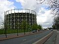
A gasholder in Bradford, Manchester. Gasholders store gas.

