Braunau am Inn facts for kids
Quick facts for kids
Braunau am Inn
|
|||
|---|---|---|---|
|
Municipality
|
|||
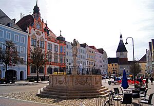
Braunau town centre
|
|||
|
|||
| Country | Austria | ||
| State | Upper Austria | ||
| District | Braunau am Inn | ||
| Area | |||
| • Total | 24.84 km2 (9.59 sq mi) | ||
| Elevation | 352 m (1,155 ft) | ||
| Population
(2018-01-01)
|
|||
| • Total | 17,095 | ||
| • Density | 688.20/km2 (1,782.4/sq mi) | ||
| Time zone | UTC+1 (CET) | ||
| • Summer (DST) | UTC+2 (CEST) | ||
| Postal code |
5280, 5282A
|
||
| Area code | 07722 | ||
| Vehicle registration | BR | ||
Braunau am Inn is a town in Upper Austria. It sits right on the border with Bavaria, a state in Germany. The town is famous for being the birthplace of Adolf Hitler.
Contents
Geography
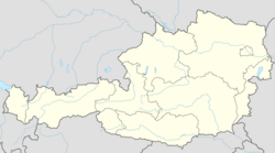
Braunau am Inn is located on the Inn River. This river forms the border with the German state of Bavaria. The town is about 60 kilometers (37 miles) north of Salzburg. It is also halfway between Linz, the capital of Upper Austria, and Munich, the capital of Bavaria.
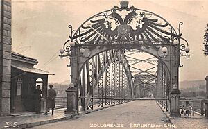
Braunau is connected to Simbach am Inn in Bavaria by bridges over the Inn River. Before 1997, there were border checks here. But since Austria joined the Schengen Agreement, people can cross freely.
The town gives its name to the larger administrative area, called a district. In 2011, Braunau am Inn had a population of 16,182 people.
Town Areas
The town of Braunau am Inn includes several smaller areas. These are Braunau am Inn, Osternberg, and Ranshofen. Here are some of the populated places within the town, with their populations as of January 1, 2022:
- Aching (22)
- Au (11)
- Blankenbach (105)
- Braunau am Inn (4308)
- Braunau Neustadt (2037)
- Gasteig (30)
- Haiden (91)
- Haselbach (2940)
- Himmellindach (178)
- Höft (12)
- Laab (3069)
- Lach (96)
- Lindach (19)
- Maierhof (114)
- Neue Heimat (1015)
- Oberrothenbuch (24)
- Osternberg (502)
- Ranshofen (2372)
- Roith (21)
- Scheuhub (400)
- Tal (89)
- Unterrothenbuch (31)
History
The area around Braunau has a long history. A nearby abbey, Ranshofen, was first mentioned in 788. The town of Braunau itself was first recorded in 1120. At that time, the region was part of the Duchy of Bavaria.
Braunau became a town with its own rights in 1260. This made it one of the first towns in what is now Austria. It grew into an important fortress town and a busy trading spot. People traded salt and used the Inn River for shipping goods.
The town played a role in the Bavarian People's Uprising in 1705. This was when Bavarians fought against Austrian control during the War of the Spanish Succession. Braunau hosted a temporary Bavarian Parliament during this time.
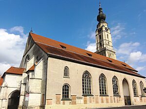
The beautiful Late Gothic St Stephen's Church was built between 1439 and 1466. Its tall spire, 87 meters (285 feet) high, is a famous landmark. Parts of the old town walls can still be seen today. The remains of the fortress now hold a museum.
Over 40 years, Braunau changed hands three times. In 1779, it became Austrian after the Treaty of Teschen. Then, in 1809, it became Bavarian again under the Treaty of Schönbrunn. Finally, in 1816, after the Napoleonic Wars, Braunau became part of the Austrian Empire. It has been Austrian ever since.
Braunau was a military town for the Austro-Hungarian Army. During World War I, it had a large prisoner of war camp. After Austria joined Nazi Germany in 1938, Ranshofen, which had a big aluminum factory, became part of Braunau.
Since 1992, the town has held annual "Braunau Contemporary History Days." These events focus on understanding the past. The town also gives out the Egon Ranshofen-Wertheimer Award to honor Austrians living abroad who have made a difference.
Adolf Hitler's Birthplace
Adolf Hitler was born in Braunau am Inn on April 20, 1889. His father worked there as a customs official. The family moved away from Braunau in 1892. Hitler was born in an apartment building at Salzburger Vorstadt 15. This building had a brewery and several rental apartments.
In April 1938, Braunau renamed the street where Hitler was born to "Adolf-Hitler-Straße." The town square was also renamed "Adolf-Hitler-Platz." That same year, the Nazi Party bought the building. It became a place for Nazi followers, with an art gallery and a library.
At the end of World War II in 1945, American soldiers took over the house. They stopped Nazi supporters from blowing it up. After the war, it was used for an exhibition about Nazi concentration camps. In 1952, the original owners bought it back. It was then used as a city library, a college, and later a day-care center for people with disabilities.
The house has been a sensitive topic for the town and the Austrian government. In 1972, the Austrian government leased the building. This was to prevent it from becoming a place where Nazi supporters would gather.
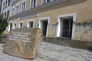
In April 1989, a Hitler birthplace memorial stone was placed in front of the building. This stone remembers the victims of World War II. It is made of granite from the Mauthausen concentration camp. The stone says: "For peace, freedom and democracy; never again fascism: millions of dead remind us." This memorial helps discourage "Hitler tourism."
In 2011, the day-care center moved out. The owner refused to sell the house to the government. So, the house remained empty.
In 2016, the government decided to take ownership of the house. This required a special law. An Austrian government group looked at different ideas for the house. They thought about turning it back into apartments, making it a center or museum about Austria's Nazi past, or even tearing it down.
On October 18, 2016, the Austrian interior minister said the building would be changed so much that it "will not be recognizable." The plan was to make it look like it did in 1790. This included removing all changes made by the Nazis in 1938.
In June 2020, it was announced that the house would become a police station after its restoration. The work was delayed by the COVID-19 pandemic, and costs went up. In 2023, it was announced that it would also be a training center. The restoration is expected to finish in 2025. The police station and district police headquarters are planned to move in during 2026.
Population
The population of Braunau am Inn has changed over the years:
- 1869: 4,553
- 1880: 5,078
- 1890: 5,584
- 1900: 6,021
- 1910: 6,340
- 1923: 6,678
- 1934: 6,998
- 1939: 7,850
- 1951: 12,013
- 1961: 14,457
- 1971: 16,436
- 1981: 16,318
- 1991: 16,264
- 2001: 16,337
- 2011: 16,182
- 2015: 16,380
- 2021: 17,438
Economy
Braunau has many different types of businesses. These include electronics, metal production (like AMAG), woodworking, and glass making. The town also has the largest aluminum factory in Austria.
Education
The BHAK Braunau is the oldest school in the Innviertel region.
The HTL Braunau is a technical school. It has been named "Most Innovative School in Upper Austria" seven times. This happened in 2012-2014 and again from 2017–2020.
Sport
The local football team, SV Braunau, played in the Austrian 1st Division. But the team went bankrupt in 2000. A new team, FC Braunau, was then started.
Notable Residents
Many interesting people have lived in Braunau:
- Hans Staininger (1508–1567), a mayor of Braunau. He was known for his very long beard.
- Franz Xaver Gruber (1787–1863), a teacher and musician. He wrote the famous Christmas song Silent Night.
- Josef Reiter (1862–1939), an Austrian composer.
- Edmund Glaise-Horstenau (1882–1946), a military historian.
- Franz Jetzinger (1882 in Ranshofen – 1965), a priest and professor.
- Angela Hitler (1883–1949), Adolf Hitler's older half-sister.
- Adolf Hitler (1889–1945), the leader of Nazi Germany.
- Egon Ranshofen-Wertheimer (1894–1957), a diplomat and journalist.
- Willi Schneider (1903–1971) and Rudi Schneider (1908–1957), brothers famous for their work in parapsychology.
- Ruthilde Boesch (1918–2012), an Austrian opera singer.
- Gerhard Skiba (1947–2019), a mayor of Braunau. He helped set up the memorial stone for victims of fascism.
- Klaus Eberhartinger (born 1950), a singer and TV presenter.
- Wilfried Scharf (born 1955), a zither player.
- Susanne Riess (born 1961), a politician.
- Albert Hainz (born 1964), a cyclist born in Ranshofen.
- Gero Miesenböck (born 1965), a neurophysiologist.
- Dominik Landertinger (born 1988), a biathlete with several Olympic medals.
Climate
Braunau am Inn has a climate with warm summers and fairly cold winters. It gets a good amount of rain throughout the year.
See also
 In Spanish: Braunau am Inn para niños
 | James Van Der Zee |
 | Alma Thomas |
 | Ellis Wilson |
 | Margaret Taylor-Burroughs |


