
Bridgetown facts for kids
Quick facts for kids
Bridgetown
|
||
|---|---|---|
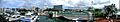
 _(17025042288).jpg) _(17025049548).jpg) .jpg) _(17025262390).jpg) Top: View of Bridgetown from Carlisle Bay; Middle: Downtown Bridgetown, Parliament Buildings; National Heroes Square, Cathedral Church of Saint Michael and All Angels
|
||
|
||

Location of Bridgetown (red star)
|
||

Bridgetown
Location in Barbados
|
||
| Country | Barbados | |
| Parish | Saint Michael | |
| Established | 1628 | |
| City status | 1824 | |
| Area | ||
| • Total | 15 sq mi (40 km2) | |
| Elevation | 3 ft (1 m) | |
| Population
(2014)
|
||
| • Total | 110,000 | |
| • Density | 7,300/sq mi (2,830/km2) | |
| Time zone | UTC−04:00 (Atlantic Standard Time) | |
| Area code(s) | +1 246 | |
| Official name: Historic Bridgetown and its Garrison | ||
| Type: | Cultural | |
| Criteria: | ii, iii, vi | |
| Designated: | 2011 | |
| Reference #: | 1376 | |
| Region: | Americas | |

Bridgetown is the capital and largest city of Barbados. It was once called "The Town of Saint Michael". Locals often call it "The City" or simply "Town". In 2014, about 110,000 people lived in the greater Bridgetown area. It is located in the parish of Saint Michael.
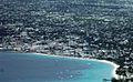
The port of Bridgetown is on the southwest coast of the island, along Carlisle Bay. The Grantley Adams International Airport is about 16 kilometers (10 miles) southeast of the city center. It has daily flights to major cities around the world. Bridgetown does not have its own local government anymore. Instead, it is a constituency within the national Parliament.
English settlers founded the city in 1628. Bridgetown is a popular tourist spot in the Caribbean. It is also an important center for finance, information technology, and cruise ship visits. In 2011, "Historic Bridgetown and its Garrison" became a World Heritage Site recognized by UNESCO.
Contents
Discovering Bridgetown's Past
When the British arrived, the island was empty. But they found a simple bridge built over a swamp in the center of Bridgetown. People believe this bridge was made by the Tainos, who were native to the Caribbean. The British called the area "Indian Bridge." It is thought that the Tainos left Barbados for Saint Lucia after an invasion by the Kalinagos.
After 1654, the British built a new bridge. The area then became known as "The Town of Saint Michael." Later, it was renamed "Bridgetown."
Bridgetown is the only city outside the United States that George Washington ever visited. The house where he stayed, George Washington House, is now part of the Garrison Historic Area. In 2011, UNESCO protected many historic buildings in Bridgetown.
Early Days of Settlement

.jpg)
English settlers began to build Bridgetown on July 5, 1628. Charles Wolverstone led 64 settlers to the land. This land was claimed by James Hay, 1st Earl of Carlisle. Wolverstone was sent by London merchants who had leased the land from the Earl of Carlisle.
Bridgetown was designed with narrow, winding streets, much like old English market towns. Between 1627 and 1807, about 387,000 enslaved Africans were brought to Barbados.
From Town to City Status
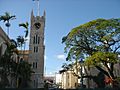
In 1824, Bridgetown became the main center for the Anglican Diocese of Barbados. The St Michael's Parish Church became a cathedral, which made Bridgetown a city. In 1842, a royal decree officially named it the City of Bridgetown.
From 1800 to 1885, Bridgetown was the main government seat for the British Windward Islands. The Governor of Barbados also led the Windward Islands during this time. When Barbados left this union in 1885, the capital moved to St. George's in Grenada.

In 1958, Barbados passed a law for local government. This law gave Bridgetown its own administration with a mayor and council members. On September 20, 1960, the city received its own coat of arms.
However, local government in Barbados did not last long. In 1967, the local councils were ended. Today, members of the Barbadian parliament manage Bridgetown and its surrounding areas.
Geography and Climate
Bridgetown's Location

When Bridgetown was first built in the 1600s, its center was a swamp. This swamp was quickly drained and filled in to create space for the city.
City Limits
The first official boundaries of Bridgetown were set in 1660. The southern edge was the River (Careenage). The western edge was the St. Michael's Churchyard. The city's boundaries were not changed until 1822.
Today, the wider Bridgetown area covers most of the parish of Saint Michael. This area is about 39 square kilometers (15 square miles).
The Careenage Waterway
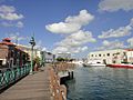
At the heart of Bridgetown are the Careenage and Constitution River. The Careenage is like a marina for boats entering the inner harbor. This waterway gives the city direct access for medium-sized yachts and small boats. The Careenage divides Bridgetown into two parts. During the rainy season, the Constitution River flows into the Careenage. It helps drain water from the country's interior.
Weather in Bridgetown
Bridgetown has a tropical savanna climate. This means temperatures stay fairly constant all year. It is usually hot, but trade winds help to cool the city. Bridgetown has a clear wet season from June to December and a shorter dry season for the rest of the year.
| Weather chart for Bridgetown, Barbados | |||||||||||||||||||||||||||||||||||||||||||||||
|---|---|---|---|---|---|---|---|---|---|---|---|---|---|---|---|---|---|---|---|---|---|---|---|---|---|---|---|---|---|---|---|---|---|---|---|---|---|---|---|---|---|---|---|---|---|---|---|
| J | F | M | A | M | J | J | A | S | O | N | D | ||||||||||||||||||||||||||||||||||||
|
68
29
23
|
42
29
23
|
39
30
23
|
58
30
24
|
74
31
25
|
101
31
25
|
122
31
25
|
151
31
25
|
163
31
25
|
180
31
25
|
173
30
25
|
91
30
24
|
||||||||||||||||||||||||||||||||||||
| temperatures in °C precipitation totals in mm |
|||||||||||||||||||||||||||||||||||||||||||||||
|
Imperial conversion
|
|||||||||||||||||||||||||||||||||||||||||||||||
| Climate data for Bridgetown (Grantley Adams International Airport) 1991–2020, extremes 1944–present | |||||||||||||
|---|---|---|---|---|---|---|---|---|---|---|---|---|---|
| Month | Jan | Feb | Mar | Apr | May | Jun | Jul | Aug | Sep | Oct | Nov | Dec | Year |
| Record high °C (°F) | 32.0 (89.6) |
31.2 (88.2) |
31.9 (89.4) |
32.6 (90.7) |
33.1 (91.6) |
32.7 (90.9) |
32.4 (90.3) |
35.0 (95.0) |
33.3 (91.9) |
33.3 (91.9) |
33.3 (91.9) |
31.3 (88.3) |
35.0 (95.0) |
| Mean daily maximum °C (°F) | 29.1 (84.4) |
29.2 (84.6) |
29.7 (85.5) |
30.2 (86.4) |
30.6 (87.1) |
30.7 (87.3) |
30.7 (87.3) |
30.9 (87.6) |
31.0 (87.8) |
30.8 (87.4) |
30.3 (86.5) |
29.6 (85.3) |
30.2 (86.4) |
| Daily mean °C (°F) | 26.0 (78.8) |
25.9 (78.6) |
26.3 (79.3) |
27.0 (80.6) |
27.7 (81.9) |
27.8 (82.0) |
27.8 (82.0) |
27.9 (82.2) |
27.9 (82.2) |
27.7 (81.9) |
27.2 (81.0) |
26.6 (79.9) |
27.2 (80.9) |
| Mean daily minimum °C (°F) | 23.3 (73.9) |
23.0 (73.4) |
23.4 (74.1) |
24.2 (75.6) |
25.0 (77.0) |
25.2 (77.4) |
25.1 (77.2) |
24.8 (76.6) |
24.8 (76.6) |
24.7 (76.5) |
24.5 (76.1) |
23.9 (75.0) |
24.3 (75.8) |
| Record low °C (°F) | 16.5 (61.7) |
18.0 (64.4) |
17.4 (63.3) |
19.0 (66.2) |
19.4 (66.9) |
20.0 (68.0) |
19.3 (66.7) |
19.1 (66.4) |
20.6 (69.1) |
20.6 (69.1) |
18.0 (64.4) |
17.4 (63.3) |
16.5 (61.7) |
| Average rainfall mm (inches) | 68.1 (2.68) |
41.7 (1.64) |
38.9 (1.53) |
58.1 (2.29) |
74.1 (2.92) |
101.2 (3.98) |
121.5 (4.78) |
150.6 (5.93) |
162.6 (6.40) |
179.6 (7.07) |
172.6 (6.80) |
91.0 (3.58) |
1,260 (49.6) |
| Average rainy days | 11 | 9 | 8 | 8 | 8 | 11 | 15 | 16 | 13 | 15 | 14 | 11 | 139 |
| Average relative humidity (%) | 77 | 76 | 75 | 76 | 77 | 79 | 80 | 81 | 81 | 82 | 82 | 78 | 79 |
| Mean monthly sunshine hours | 263.5 | 248.6 | 272.8 | 261.0 | 263.5 | 225.0 | 251.1 | 260.4 | 234.0 | 238.7 | 228.0 | 254.2 | 3,000.8 |
| Mean daily sunshine hours | 8.5 | 8.8 | 8.8 | 8.7 | 8.5 | 7.5 | 8.1 | 8.4 | 7.8 | 7.7 | 7.6 | 8.2 | 8.2 |
| Source 1: Barbados Meteorological Services | |||||||||||||
| Source 2: Meteo Climat (record highs and lows) | |||||||||||||
Exploring the City of Bridgetown


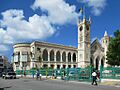
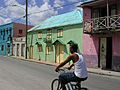
The main street in Bridgetown is Broad Street. It runs through the city center. Broad Street passes the Parliament Buildings and is the main shopping area.
Another important road into the city is Bay Street. It becomes Highway 7 and leads to the South Coast of Barbados. Other notable streets in Bridgetown include:
- Swan Street – runs next to Broad Street, to the north.
- Roebuck Street – leads towards Queens Park, north and east of Swan Street.
- Tudor Street – comes from the north, crosses Swan Street, and is at a right angle to Broad Street.
- The Spring Garden Highway – is west of the city. It hosts the annual Grand Kadooment Carnival Parade.
City Neighborhoods
Bridgetown has many neighborhoods, including:
- Belleville
- Cat's Castle
- Cheapside
- Fontabelle
- Garden Land
- New Orleans
- Pinelands
- Strathclyde
- Weymouth
- Whitepark
Famous Places to Visit
Bridgetown has many interesting landmarks and places to see:
- National Heroes Square (formerly Trafalgar Square)
- Independence Square and The Independence Arch
- The Montefiore Fountain
- Parliament Buildings of Barbados
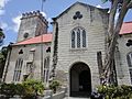
- The Cathedral Church of Saint Michael and All Angels
- The St. Mary's Anglican Church
- The St. Patrick's Roman Catholic Cathedral
- Nidhe Israel Synagogue
- The Pelican Village and Craft Centre
- Queen's Park
- The Barbados Museum
- Kensington Oval (where the 2007 Cricket World Cup final was held)
- Carlisle Bay Beach
- Cheapside market
- Rihanna Drive Monument
- The Tom Adams Financial Complex
- The Frank Collymore Hall of the Performing Arts
- The Cathedral Plaza
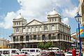
- The Cave Shepherd Department Store
- The Mutual Building
- The Cheapside Gardens
- Sagicor Plaza
- The Garrison Savannah and National Historic Area
- The Hilton Hotel
- Martineau House
- Pierhead Development Complex
Bridgetown's Harbor
The Bridgetown Port, also known as the "Deep Water Harbour," is the main entry point for cruise and cargo ships in Barbados. It is located northwest of the Careenage Canal.
This port is a major shipping and transfer hub for the entire Eastern Caribbean. In 2002, the port was deepened. This allows it to welcome the largest cruise ships in the world. The port also handles goods for the island's own needs. Barbados's main exports, mostly farm products, also use the harbor.

Bridgetown also has a smaller canal in the city center called the Careenage, or "Constitution River." This is different from the Deep Water Harbour. The Careenage is only big enough for pleasure boats or fishing boats. Two main bridges cross this shallow waterway near the city center.
Society and Culture


Bridgetown is the main center for business in Barbados. It is also the central hub for the island's public transport system. Many government offices are in the greater Bridgetown area. The Public Buildings, or parliament, are in the heart of the city. They house the third oldest continuous parliament in the British Commonwealth. Long ago, Bridgetown was the most important British city in the New World. This was because of its location in the eastern Caribbean.
The main office of the National Library Service of Barbados is in Bridgetown. It is in a coral-stone building on Coleridge Street.

Bridgetown is home to several important schools. The University of the West Indies has one of its three campuses here, in the northern suburb of Cave Hill. This campus offers great views of Bridgetown and its port. The Barbados Community College is about 3 kilometers (2 miles) east of the city center. The Samuel Jackman Prescod Polytechnic is just outside the city's eastern edge.
The city also has well-known secondary schools like Harrison College and Combermere. The American University of Barbados, School of Medicine, is about 4 kilometers (2.5 miles) east of Bridgetown.
Bridgetown hosted the 1994 United Nations Global Conference on Sustainable Development of Small Islands States. Bridgetown has branches of some of the world's largest banks. It is known as a growing financial center. The city was greatly improved for the 2007 Cricket World Cup Finals. The Kensington Oval stadium was updated to hold 30,000 fans. Over 100 million people worldwide watched the 2007 event.
City Services
Today, Bridgetown is a modern and busy city. It has many services like clean piped water, electricity, natural gas, and advanced telecommunications. There are also internet cafes and good infrastructure. The city also has a large conference center called the Sherbourne Conference Centre.
- Electricity – Barbados Light and Power Company Ltd. (BL&P)
- Water – Barbados Water Authority (BWA)
- Telecommunications – Digicel, FLOW, and WIISCOM
- Television – CBC TV 8, Multi-Choice TV (Barbados), and DirecTV
- Radio – List of radio stations in Barbados
Economy and Business
Barbados's main exports are sugar, rum, and molasses. The island also has other important industries like tourism and offshore finance.
Stock Exchange
- Barbados Stock Exchange (BSE) – Bridgetown has a stock exchange where you can buy shares in Barbadian and Caribbean companies.
Business Information
Banks are usually open from 8:00 AM to 3:00 PM, Monday to Thursday. On Fridays, they are open from 8:00 AM to 5:00 PM.
The main banks include:
- Bank of Nova Scotia
- Republic Bank
- Canadian Imperial Bank of Commerce (CIBC) (now FirstCaribbean International Bank)
- First Citizens
- Royal Bank of Canada (RBC)
You can find Automatic Teller Machines (ATMs) easily.
Shops are usually open from 8:00 AM to 6:00 PM on weekdays. On Saturdays, they are open from 8:00 AM to 12:00 PM. Most places accept payment cards.
Electricity is 115 volts AC, 50 cycles. Many hotels also have 220 AC.
To call Barbados from another country, dial +1.246, then the seven-digit phone number. If you are on the island, just dial the seven digits. To call the United States or Canada from Barbados, dial +1, then the area code, then the seven-digit phone number.
Emergency numbers:
- Police: 211 (for emergencies only)
- Fire: 311
- Ambulance: 511
- Coast Guard and Defense Force: +1.246.427.8819
Getting Around Bridgetown
The city has daily flights from the Sir Grantley Adams International Airport (GAIA). This airport is located in Seawell, Christ Church. Bridgetown and New York City were the only cities in the western hemisphere to have regular British Airways Concorde flights. The GAIA is also one of only four places in the world where retired Concorde aircraft are displayed. The airport is expanding and will have a museum for the Concorde.
All seven of Barbados's main highways start near Bridgetown. They spread out to the north, south, and east of the island. In Barbados, people drive on the left side of the road. The speed limit is 60 km/h (37 mph) in built-up areas. On the ABC Highway, the speed limit is usually 80 km/h (50 mph). Water transport is managed by the Barbados Port Authority.
Public Buses
Buses going north to places like Holetown and Speightstown, and to parts of St. Michael like the University of the West Indies, leave from the Princess Alice Bus Terminal. This terminal is west of the city center. Buses going east and south leave from the Fairchild Street Bus Terminal. This terminal is on the eastern edge of the city center, near the Queen Elizabeth Hospital.
Route Taxis
Route taxis are privately owned minivans. They operate like taxicabs that you can hire.
International Connections
Sister Cities
Bridgetown is connected with these cities around the world:
 Bridgetown, Nova Scotia, Canada (since 2004)
 Hackney, United Kingdom (since 1982)
 Hunan province, China (since 2023)
 Wilmington, North Carolina, United States (since 2004)
Famous People from Bridgetown

- Jofra Archer, cricketer
- Stede Bonnet, a famous pirate known as "The Gentleman Pirate"
- Richard Clement Moody, who founded British Columbia
- Anthony Forde, darts player
- Grandmaster Flash, rapper
- Orlando Greene, Olympic runner
- Dawn-Marie Layne, cricketer
- Zane Maloney, racecar driver and 2019 British F4 champion
- Malcolm Marshall, cricketer
- Jackie Opel, known for creating a music style called Spouge
- Rihanna, singer and songwriter
- Kyffin Simpson racecar driver and 2021 Formula Regional Americas champion
- Sir Garfield Sobers, cricketer
- Sir Clyde Walcott, cricketer
- Sir Everton Weekes, cricketer
- Sir Frank Worrell, cricketer
- Dame Sandra Mason, the first President of Barbados
Images for kids
-
Bridgetown, showing Chamberlain Bridge and Parliament Building
-
Central Bridgetown
-
View from National Heroes Square, Bridgetown, Barbados, April 2007
-
Parliament Building
-
Walk along canal
-
Colourful Bridgetown street
-
St. Michael's Cathedral
-
The iconic Barbados Mutual Life Assurance Society building from Broad Street
-
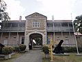
Barbados Museum and Historical Society at the military prison at St. Ann's Garrison
.jpg)

See also
 In Spanish: Bridgetown para niños
