Broxton Rocks facts for kids
Quick facts for kids Broxton RocksStratigraphic range: Middle Miocene~42–5.2Ma |
|
|---|---|

Broxton Rocks Waterfall
|
|
| Type | Geological formation |
| Unit of | Altamaha Formation |
| Underlies | Atlantic coastal plain |
| Lithology | |
| Primary | Sandstone |
| Other | Mudstone |
| Location | |
| Coordinates | 31°43′56″N 82°51′12″W / 31.7323°N 82.8533°W |
| Region | Broxton, Coffee County, Georgia |
| Country | |
| Extent | 4 miles (6.4 km) |
| Type section | |
| Named for | Broxton, Georgia |
| Named by | Huddleston |
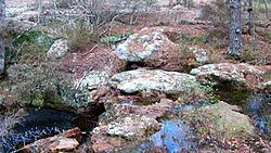
Broxton Rocks is a unique natural area in Georgia, USA. It's the biggest place where you can see a type of rock called sandstone above ground. This sandstone stretches for about 4 miles (6.4 km). It's part of a huge underground rock layer called the Altamaha Grit. This layer lies beneath a large part of the Atlantic Coastal Plain.
Locally, people often call this area "The Rocks". It's a cool place with lots of cracks, small pools, and damp rock walls. There's even a 10-foot (3 meter) waterfall! Rocky Creek has carved out a shallow gorge here over many centuries. The Broxton Rocks waterfall is the southernmost waterfall in Georgia.
A big part of Broxton Rocks is a protected area called the Broxton Rocks Preserve. It covers 3,799 acres (1,537 hectares). A large section of this preserve, 1,528 acres (618 hectares), is looked after by The Nature Conservancy. The preserve is located in north-east Coffee County, Georgia. It's about 185 miles (298 km) from Atlanta and 145 miles (233 km) from Jacksonville, Florida.
Contents
How Broxton Rocks Formed
Broxton Rocks is part of the Atlantic coastal plain. Its sandstone layers were created a long, long time ago. This happened as the Altamaha Formation slowly wore away. This process dates back to the Middle Miocene era.
Over time, cracks have opened up in the rock. Some of these cracks are wide enough for a person to walk through. Others are narrow but very deep. Rocky Creek, a small stream that sometimes dries up, flows through the area. Where the water drops to a lower level, it has formed a 10-foot (3 meter) waterfall. This waterfall has created a pool in the sandstone. The water then flows out and eventually drains into the Ocmulgee River.
Amazing Plants and Animals
Broxton Rocks is a special place for nature. It's home to many different kinds of plants and animals.
Unique Plants
Broxton Rocks has about 530 different kinds of plants! Some of these plants are very rare. They are either endangered or threatened. This means they are at risk of disappearing forever.
Some of the special plants found here include:
- Green-fly orchid
- Grit portulaca
- Silky creeping morning glory
- Georgia plume
- Filmy fern
- Shoestring fern
Some plants found at Broxton Rocks were once thought to be extinct. Others usually grow in different climates, like tropical areas or the Appalachian Mountains. In spring, flowers like flame azaleas and fameflower add bright colors to the ravine. The preserve is also part of a longleaf pine forest. This type of forest used to cover a huge area from the Atlantic Ocean all the way to Texas. The Nature Conservancy is working to bring back the longleaf pine trees to the lands they manage in the preserve.
Cool Animals
The preserve is also home to over 100 types of birds. You might spot the Bachman's sparrow, which is almost threatened. You might also hear the loud, drumming sound of a pileated woodpecker.
Other animals living here include:
- Armadillo
- Woodrat
- Flying squirrel
- Gopher tortoise, which is vulnerable
- Indigo snake, which is threatened
- These terms describe how at-risk a species is.
A Look at Human History
Scientists have found signs that people lived at Broxton Rocks a long time ago. Archaeological research shows there was a dwelling here during the Spanish era (1568–1684). It is believed to have belonged to aboriginal peoples.
Broxton Rocks has had a few different names over the years. About thirty years ago, people often called it simply The Rocks. An old book from 1930, Ward's History of Coffee County, mentions it too. It says the area was known as "The Picnic Rocks." Even before that, it was called "falling waters" because of the waterfall. It's not clear if "falling waters" was a translation from a local Native American language, like Creek or Seminole.

