
Bryngarw Country Park facts for kids
Quick facts for kids Bryngarw Country Park |
|
|---|---|

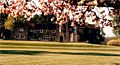
Aerial view of Bryngarw House and Lawn 1986/87
|
|
| Lua error in Module:Location_map at line 420: attempt to index field 'wikibase' (a nil value). | |
| Type | Park |
| Location | Bridgend County Borough, Wales |
| Area | 48 hectares (120 acres) |
Bryngarw Country Park is a beautiful place in Bridgend County Borough, Wales. It covers about 48 hectares (that's like 118 football fields!). The park is located next to the River Garw, which flows through the Garw Valley. It's a mix of woodlands, meadows, wetlands, and lovely gardens.
Bryngarw Country Park aims to connect people with nature and history. It's a bridge between city life and the countryside. Many people visit each year, with 50,000 to 70,000 visitors enjoying the park. Around 1,500 to 2,000 children come for school trips and special events. The park's rangers also host fun activities for everyone.
The park is really special! In 2010, it won its first Green Flag award. This award means the park is great at looking after its natural spaces. It also provides excellent facilities for visitors. Bryngarw Country Park won this award again in 2011.
Bryngarw Park is also a Grade II listed Historic Park and Garden. This means it's an important historical site. The main house is also a Grade II listed building. The park has received funding to improve its visitor centre, café, and car park. They also plan to make the beautiful oriental gardens even better!
Contents
Park History

Bryngarw House might have been built in the 15th century as a farmhouse. The first official record of the house is from 1743. In 1775, the house became a wedding gift to the Traherne family. They made many changes to the building.
The last Traherne family member to live there was Captain Onslow Powell Traherne. He was an explorer and businessman. Between 1910 and 1920, he updated the house and created the formal gardens. He brought in many unusual plants from around the world. These included different kinds of rhododendrons, magnolias, and even ginkgo biloba trees. Later, Captain Traherne sold the estate in the late 1940s.
In 1961, the house became public property. It was divided into nine flats for people to live in. Caravans were also placed where the kitchen garden used to be. By 1980, the house was empty and falling apart. But then, Bryngarw was chosen to become a Country Park!
Work began in 1982 to fix up the park. Paths were built, and the lake and gardens were restored. A car park and public facilities like toilets and a café were also added. Bryngarw Country Park officially opened on May 23, 1986. The house was fully restored in 1993 with special funding.
-
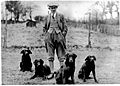
Captain Onslow Powell Traherne
-
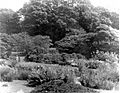
Oriental Garden around 1940
-
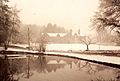
Bryngarw House around 1960
-
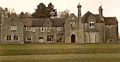
Bryngarw House around 1980
-
Bryngarw House around 1990
-
Bryngarw House in 2011


Woodland Areas


Bryngarw Country Park has several different woodland areas. They are all managed to keep the trees healthy and help wildlife thrive.
Coed Waunpiod West
This woodland is in the park's southwest corner. It has many sweet chestnut trees, along with oak, silver birch, and holly. Park rangers have been thinning out the trees here. This helps the stronger trees grow better. You might spot speckled wood butterflies, wood mice, and green or great spotted woodpeckers here.
Coed Waunpiod East
You'll find this woodland in the park's southeast, right next to the River Garw. Because it's so close to the river, it's a "wet woodland." It's a special place called a Site of Interest for Nature Conservation (SINC). This is because it has rare alder tree areas called alder carr.
A unique part of this woodland is the "wet triangle." It's a small, open area that stays very wet, even in winter. It's a great spot for wildflowers. You might see butterflies, dragonflies, dippers, herons, and even otters near the river.
Sycamore Wood
The Sycamore wood is the highest point in the park, in the northwest corner. It used to be an ancient woodland. Later, it was replanted with sycamore trees. Now, the park is adding native trees like oak and hazel to make the woodland healthier. In mid-April, this area is famous for its beautiful bluebells.
Coed Kensington
This is a lovely deciduous woodland in the northern part of the park. Rangers manage it by cutting back some trees in a rotation. This helps new growth and keeps the woodland healthy. Look out for great spotted woodpeckers, lesser spotted woodpeckers, and animals like stoats and weasels here.
The "Beech Avenue" marks the western edge of Coed Kensington. These 21 beech trees were planted in 1837. Local legend says they were planted to celebrate Queen Victoria's 21st birthday! Many of these old trees are now home to bats. Because bats are protected, the park has to be very careful when working near these trees.
Wet Woodland
This woodland stretches from the oriental garden north to the park's boundary. It's often semi-flooded because it's so close to the River Garw. This makes it a perfect spot for ground-nesting birds. The damp conditions are also great for fungi and many kinds of invertebrates.
Meadowland Areas
Rhos Pasture

"Rhos pasture" is a Welsh term for 'rough' grassland. It's found in wet, nutrient-poor soil and is dominated by rushes and tough grasses. This small area in the park's southwest is a favorite spot for birds and insects. It's kept healthy by cattle grazing there at the end of summer.
Meadows

The park has two meadows on its western side, near the barbecue and adventure playground. These meadows are very important for nature. They have many low-growing plants and insects like butterflies. You might also see birds like whitethroats and redstarts along the hedgerows.
The meadows are cut once a year to help wildflowers grow. This also keeps the soil healthy. A path is mown through the area for visitors to enjoy.
Farmland
About 18 hectares of the park are rented out for grazing. This land is managed to help nature thrive. It also acts as a buffer zone for the park and helps bring in extra money.
Wetland Areas
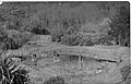
Ornamental Lake and Ponds


The lake in front of Bryngarw House is fed by a spring. It's home to many semi-domesticated ducks. You can also find different types of fish like perch and tench. Wild visitors include kingfishers, mink, and herons. There's a small island in the lake that provides shelter for young birds.
The lake was originally built by Captain Traherne. After years of neglect, it became marshy. But it was dredged and restored before the park opened in 1986.
In the oriental garden, there are three smaller ponds. These ponds are home to common toads, common frogs, and palmate newts. They also have many different water insects like water boatman and dragonfly larvae.
River Garw

The River Garw means 'rugged river' in Welsh. It flows from Blaengarw, 12 miles north, and joins the River Ogmore. It used to be called the 'black river' because of coal washing. But now, the river is clean and healthy. It's home to otters, bats, kingfishers, and dippers.
House and Gardens
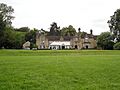
Bryngarw House and Lawn
Bryngarw House now works mostly as a hotel. It has 19 bedrooms, each with its own bathroom. The Harlequin Restaurant is inside the house. You can eat in the large conservatory and look out over the lawn.
The house also hosts weddings, parties, and meetings. The lawn area is perfect for playing, picnicking, and relaxing.
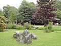
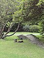
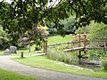
Oriental Garden
This garden was created between 1910 and 1920 by Captain Traherne. It's where he planted many of his exotic trees. The Japanese-style bridge and tea house are newer additions. This garden is being restored in 2011 to bring back its original beauty.
-
Oriental Garden around 1940
-
Oriental Garden in 2011
-
Oriental Garden in 2011
-
Oriental Garden in 2011


Orchard

The Orchard used to be the kitchen garden for Bryngarw House. It has many old fruit trees. After years of neglect, the park rangers started a project in 2010 to restore it. They've added new apple, pear, and plum trees. The old hedges have also been restored.
The open space in the orchard helps wildflowers grow. You can find bluebells, primroses, and cowslips here.
Woodland Garden

The Woodland Garden is north of the orchard. It was once the house's herb garden. In 2005, rangers turned it into a special area that is easy for wheelchairs to access. It's also used for school trips. You'll find large wood carvings here that help teach about nature.
Fun Areas
Visitor Centre, Café, and Toilets


The visitor centre, café, and toilets are at the north end of the car park. They were built in 1982 and are being updated. The visitor centre has displays about the park's wildlife and history. You can also find maps and leaflets.
The café serves hot and cold drinks, snacks, and ice cream. You can even buy duck food! It's usually open from 10 am to 5 pm in the summer. The roofs of these buildings are also home to pipistrelle and brown long-eared bats.
Adventure Play Area
The adventure play area is in the western part of the park. It has a tall slide with three chutes, swings, and climbing structures. There's also a climbing boulder in the barbecue area.
Barbecue and Picnic Areas
There are several picnic spots, but the largest is north of the play area. You can rent barbecue stands here. The park asks that you only barbecue in this area and keep your barbecue off the grass. This is a very popular spot for families with children.
Suggested Walks
All these walks start and end at the visitor centre. They follow well-kept paths but might have some steps or small slopes. Paths through woodlands can have tree roots, so they might be tricky for wheelchairs or pushchairs. You can find more details in the leaflet Nature Watch: A guide to walks in Bryngarw Country Park.
Riverside Ramble
This walk is half a mile long and follows blue markers. It takes you through Coed Waunpiod east, the wet triangle, and along the River Garw. You can also extend it to visit the Oriental Garden.
Meadow Meander
This walk is also half a mile long and follows red markers. It guides you through the park's two meadows. This is a great way to see wildflowers.
Woodland Walk
This walk is three-quarters of a mile long and follows green markers. Part of this walk, the Beech Avenue, is currently closed. But there's a clearly marked detour with yellow arrows. This route takes you around the Lake, Orchard, Woodland Garden, Sycamore woods, Coed Kensington, and Wet woodland. It's the longest walk and has some steep slopes.
Get Involved!
Friends of Bryngarw and Volunteering
The park rangers, Keith and Dan, organize "Volunteer days." These usually happen on the first Saturday of each month. Volunteers help with tasks like woodland management, river clean-ups, and building nature trails. It's a great way to help the park and meet new people!
Events
Bryngarw Country Park hosts many events throughout the year. These include guided walks with rangers, fun environmental days, and outdoor arts and music events. There's always something happening for all ages!
Getting Here by Train
The closest train station is Tondu. You can catch trains there provided by Transport for Wales Rail.
Images for kids
-
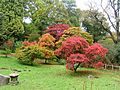
Maple in autumnal colours in the Oriental garden
-
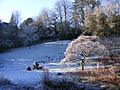
Maple covered in frost in the Oriental garden
-
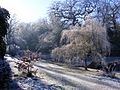
Weeping willow covered in frost in the Oriental garden


