Buchanan County, Virginia facts for kids
Quick facts for kids
Buchanan County
|
||
|---|---|---|

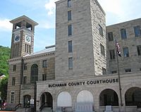
Buchanan County Courthouse in Grundy
|
||
|
||

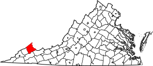
Location within the U.S. state of Virginia
|
||
 Virginia's location within the U.S. |
||
| Country | ||
| State | ||
| Founded | 1858 | |
| Named for | James Buchanan | |
| Seat | Grundy | |
| Largest town | Grundy | |
| Area | ||
| • Total | 504 sq mi (1,310 km2) | |
| • Land | 503 sq mi (1,300 km2) | |
| • Water | 1.1 sq mi (3 km2) 0.2% | |
| Population
(2020)
|
||
| • Total | 20,355 | |
| • Estimate
(2023)
|
19,087 |
|
| • Density | 40.39/sq mi (15.593/km2) | |
| Time zone | UTC−5 (Eastern) | |
| • Summer (DST) | UTC−4 (EDT) | |
| Congressional district | 9th | |
Buchanan County is a place in the far western part of Virginia. It's special because it's the only county in Virginia that touches both West Virginia and Kentucky. This area is part of Southwest Virginia and is located in the rugged Appalachian Mountains.
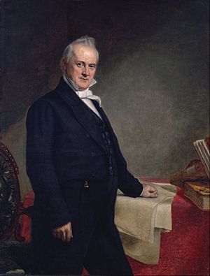
The main town and government center of Buchanan County is Grundy. The county was created in 1858. It was formed from parts of Russell and Tazewell counties. It was named after James Buchanan, who was the 15th President of the United States. However, people in the county say the name a bit differently than the president's last name.
In 1880, a part of Buchanan County was used to create Dickenson County. The population of Buchanan County was 20,355 people in 2020. Over the last 40 years, the number of people living here has gone down. The county has also faced economic challenges compared to other parts of Virginia.
Contents
History of Buchanan County
Buchanan County was officially formed in 1858. It was made from pieces of land that used to be part of Russell and Tazewell counties. The county got its name from James Buchanan, who was the 15th President of the United States.
In 1876, the town of Grundy was chosen to be the county seat. This means it's where the county government is located. Grundy was named after Felix Grundy, who was a United States Senator from Tennessee.
Later, in 1880, a part of Buchanan County was combined with parts of Russell and Wise counties. This new area became Dickenson County.
A very important person from Buchanan County was Helen Timmons Henderson (1877–1925). She worked at the Buchanan Mission School in Council, Virginia. Helen Henderson and another woman named Sarah Lee Fain were the first two women ever elected to the Virginia General Assembly. They were both members of the House of Delegates. While Helen Henderson was in office, lawmakers approved building a better road from Russell County to Council. This road is now known as Route 80, and it's also called the "Helen Henderson Highway" in her honor.
Geography and Nature
Buchanan County covers a total area of about 504 square miles. Most of this is land, with only a small amount of water. The county is known for its beautiful outdoor spaces. You can visit Poplar Gap Park near Grundy or William P. Harris Park in Council for outdoor fun.
County Districts
The county is divided into seven areas called supervisor districts. These are Garden, Hurricane, Knox, North Grundy, Prater, Rock Lick, and South Grundy.
Neighboring Counties
Buchanan County shares its borders with several other counties:
- Mingo County, West Virginia – to the north
- McDowell County, West Virginia – to the east
- Tazewell County, Virginia – to the southeast
- Russell County, Virginia – to the south
- Dickenson County, Virginia – to the southwest
- Pike County, Kentucky – to the northwest
Main Roads
The major highways that run through Buchanan County include:
 US 460
 SR 80
SR 80 SR 83
SR 83
Population Information
| Historical population | |||
|---|---|---|---|
| Census | Pop. | %± | |
| 1860 | 2,793 | — | |
| 1870 | 3,777 | 35.2% | |
| 1880 | 5,694 | 50.8% | |
| 1890 | 5,867 | 3.0% | |
| 1900 | 9,692 | 65.2% | |
| 1910 | 12,334 | 27.3% | |
| 1920 | 15,441 | 25.2% | |
| 1930 | 16,740 | 8.4% | |
| 1940 | 31,477 | 88.0% | |
| 1950 | 35,748 | 13.6% | |
| 1960 | 36,724 | 2.7% | |
| 1970 | 32,071 | −12.7% | |
| 1980 | 37,989 | 18.5% | |
| 1990 | 31,333 | −17.5% | |
| 2000 | 26,978 | −13.9% | |
| 2010 | 24,098 | −10.7% | |
| 2020 | 20,355 | −15.5% | |
| 2023 (est.) | 19,087 | −20.8% | |
| U.S. Decennial Census 1790–1960 1900–1990 1990–2000 2010 2020 |
|||
In 2020, the population of Buchanan County was 20,355 people. The county's population has been decreasing over the past few decades. Most people in the county are White, but there are also Black or African American, Asian, Native American, and multiracial residents. A small percentage of the population is Hispanic or Latino.
Schools and Learning
Buchanan County has several schools and colleges.
Colleges
Private Schools
Public High Schools
All public schools in Buchanan County are managed by the Buchanan County Public Schools system.
- Grundy Senior High School, in Grundy
- Twin Valley High School, in Pilgrims Knob
- Council High School, in Council
- Hurley High School, in Hurley
Public Elementary and Middle Schools
- Twin Valley Elem/Middle School
- Council Elementary School
- Riverview Elementary Middle School
- Hurley Elementary/Middle School
Former Schools
Some schools in Buchanan County have closed or been torn down over the years. These include:
- Harman Elementary (now a baseball field)
- Vansant Elementary
- Big Rock Elementary
- Grundy Jr. High School (now the Appalachian School of Law)
- Garden Elementary, Middle, and High Schools (Garden High is now the Appalachian College of Pharmacy)
- Jewell Valley Elementary School
- J.M. Bevins Elementary School
- Whitewood Elementary and High Schools
- D.A. Justus
- P.V. Dennis (now the ASL Library)
- Russell Prater Elementary
Communities in Buchanan County
Towns
Census-Designated Place
Other Communities
See also
 In Spanish: Condado de Buchanan (Virginia) para niños
 | Leon Lynch |
 | Milton P. Webster |
 | Ferdinand Smith |


