
Burleigh County, North Dakota facts for kids
Quick facts for kids
Burleigh County
|
||
|---|---|---|

Burleigh County Courthouse
|
||
|
||

Location within the U.S. state of North Dakota
|
||
 North Dakota's location within the U.S. |
||
| Country | ||
| State | ||
| Founded | January 4, 1873 | |
| Named for | Walter A. Burleigh | |
| Seat | Bismarck | |
| Largest city | Bismarck | |
| Area | ||
| • Total | 1,668 sq mi (4,320 km2) | |
| • Land | 1,633 sq mi (4,230 km2) | |
| • Water | 36 sq mi (90 km2) 2.1% | |
| Population
(2020)
|
||
| • Total | 98,458 | |
| • Estimate
(2023)
|
100,012 |
|
| • Density | 59.028/sq mi (22.791/km2) | |
| Time zone | UTC−6 (Central) | |
| • Summer (DST) | UTC−5 (CDT) | |
| Congressional district | At-large | |

Burleigh County is a county in the state of North Dakota. In 2020, about 98,458 people lived there. This makes it the second most populated county in North Dakota. The main city and county seat is Bismarck, which is also the state capital. The county was named after Walter A. Burleigh, an important person in the Dakota Territory.
Contents
History of Burleigh County
Burleigh County was created on January 4, 1873. This happened when the government of the Dakota Territory decided to form new areas. The county officially started operating on July 16, 1873. Its borders have changed a few times since then. Burleigh County is part of the "Bismarck–Mandan" area. This is a larger region that includes Bismarck and nearby Mandan.
Geography and Nature
The Missouri River flows along the western edge of Burleigh County. Many small creeks flow south through the middle of the county. The land here has low, rolling hills and is quite dry. Some areas are used for farming. The highest point in the county is about 2,060 feet (628 meters) above sea level. The county covers about 1,668 square miles (4,320 square kilometers). Most of this area is land, but about 36 square miles (93 square kilometers) is water.
Main Roads
You can find several important roads in Burleigh County:
 I-94
I-94 US 83
US 83 ND 14
ND 14 ND 36
ND 36 ND 41
ND 41 ND 1804
Public Transport
- Bis-Man Transit helps people get around Bismarck and Mandan.
- Jefferson Lines offers longer bus trips.
Neighboring Counties
Burleigh County shares its borders with these counties:
- Sheridan County (north)
- Kidder County (east)
- Emmons County (south)
- Morton County (southwest)
- Oliver County (west)
- McLean County (northwest)
Protected Natural Areas
The county has several special areas to protect nature:
- Arena State Game Management Area
- Bunker Lake State Game Management Area
- Canfield Lake National Wildlife Refuge
- Florence Lake National Wildlife Refuge
- Long Lake National Wildlife Refuge (part)
- Sibley Nature Park
- Wilton Mine State Game Management Area (part)
Lakes in the County
Many lakes can be found in Burleigh County:
- Bunce Lake
- Bunker Lake
- Clear Lake
- Florence Lake
- Grass Lake
- Harriet Lake
- Horseshoe Lake
- Lonetree Lake
- Long Lake
- Mitchell Lake
- New Johns Lake (part)
- O'Brien Lake
- Pelican Lake
- Rice Lake
People and Population
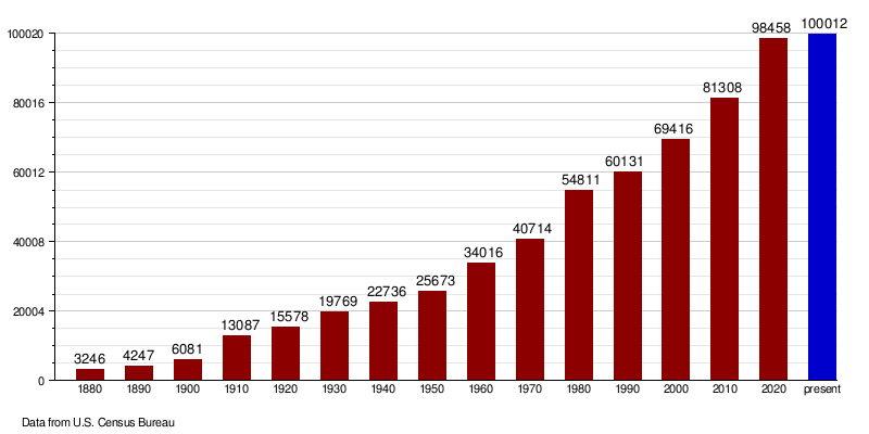
| Historical population | |||
|---|---|---|---|
| Census | Pop. | %± | |
| 1880 | 3,246 | — | |
| 1890 | 4,247 | 30.8% | |
| 1900 | 6,081 | 43.2% | |
| 1910 | 13,087 | 115.2% | |
| 1920 | 15,578 | 19.0% | |
| 1930 | 19,769 | 26.9% | |
| 1940 | 22,736 | 15.0% | |
| 1950 | 25,673 | 12.9% | |
| 1960 | 34,016 | 32.5% | |
| 1970 | 40,714 | 19.7% | |
| 1980 | 54,811 | 34.6% | |
| 1990 | 60,131 | 9.7% | |
| 2000 | 69,416 | 15.4% | |
| 2010 | 81,308 | 17.1% | |
| 2020 | 98,458 | 21.1% | |
| 2023 (est.) | 100,012 | 23.0% | |
| U.S. Decennial Census 1790-1960 1900-1990 1990-2000 2010-2020 |
|||
Population in 2020
In 2020, the county had 98,458 people. There were about 39,927 households, which are groups of people living together. The average number of people per square mile was about 60.3.
Population in 2010
In 2010, there were 81,308 people living in Burleigh County. Most people (93%) were white. About 4.2% were Native American. People from Germany (61%) and Norway (21.1%) were the largest ancestry groups. The average age of people in the county was 37.3 years old. The average income for a household was $53,465.
How the Population Has Grown
The chart below shows how the number of people living in Burleigh County has changed over many years. You can see that the population has grown a lot since 1880.
Towns and Communities
Burleigh County has several cities and smaller communities where people live.
Cities
Census-Designated Places
These are areas that are like towns but are not officially cities:
Other Communities
These are smaller, unincorporated places:
Education
Many school districts serve the children of Burleigh County.
K-12 Schools
These districts offer education from kindergarten through 12th grade:
- Bismarck Public School District 1
- Hazelton-Moffit-Braddock Public School District 6
- Kidder County School District 1
- McClusky Public School District 19
- Wilton Public School District 1
- Wing Public School District 28
Elementary Schools
These districts focus on younger students:
- Apple Creek Public School District 39
- Manning Public School District 45
- Menoken Public School District 33
- Naughton Public School District 25
- Sterling Public School District 35
See also
 In Spanish: Condado de Burleigh para niños
