
Burr Ferry, Louisiana facts for kids
Quick facts for kids
Burr Ferry
|
|
|---|---|
| Hamlet of Burr Ferry | |

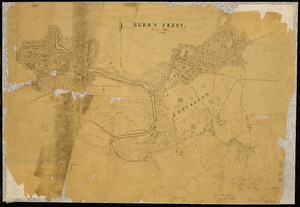
Topography of Burr Ferry
|
|

Burr Ferry
Location in Louisiana
|
|
| Country | United States |
| State | Louisiana |
| Parish | Vernon |
| Elevation | 130 ft (40 m) |
| Time zone | UTC-6 (Central (CST)) |
| • Summer (DST) | UTC-5 (CDT) |
Burr Ferry is a small, unincorporated community in Vernon Parish, Louisiana, United States. It is located where two roads, LA 8 and LA 111 South, meet. This community is very close to the Sabine River, which forms the border with Texas. The river crossing here, known as Burr's Ferry, is famous for two historic sites: the Burr's Ferry Bridge and the Burr's Ferry Earthworks. Today, Burr Ferry has a few homes, two churches, and a store, but its history is full of interesting stories.
Contents
Exploring the Nolan Trace
LA 8, the road that runs through Burr Ferry, is also called the Nolan Trace. It's named after an adventurer named Philip Nolan. He traveled this road many times between Louisiana and Texas.
In 1801, Nolan made his last trip through Burr Ferry. Sadly, this journey ended badly in east Texas. He was killed by the Royal Spanish army, and his group of about 20 people was captured. One of the captured men, Peter Ellis Bean, later wrote about their adventure.
Around 1820, a man named Dr. Timothy Burr and his family settled in this area. His grandfather was Timothy Burr from Fairfield, Connecticut.
Burr Ferry's Past
Dr. Burr came to the area from Ohio. While some records say he first visited in 1809, he definitely brought his family and others to settle here in the early 1820s. When they arrived, they weren't the only ones. The ferry here was first called "Hickman's Ferry" before it was renamed Burr's Ferry.
The "No Man's Land" Mystery
The land where Dr. Burr settled was once a disputed area between countries. After the Louisiana Purchase in 1803, the western border of the United States wasn't clear. This led to arguments involving France, New Spain, Mexico, and the United States over many years. This period of confusion and lack of law even lasted into the late 1800s when Texas was its own Republic.
Spain and the United States didn't want to fight a war over the border. So, in 1806, they made a peace agreement. General James Wilkinson of the U.S. and Lt. Col. Sim'on de Herrera of Spain signed a deal. They agreed to remove their troops from a "neutral strip" of land. This ended three years of arguments and small fights.
What was the Neutral Ground?
- This special area was called the Neutral Ground. It was also known as the Neutral Strip or "No Man's Land" of Louisiana.
- It included what is now Vernon Parish. The Sabine River was its western edge, and the Arroyo Hondo was its eastern border.
No settlers were supposed to live there, but people ignored that rule. With no soldiers or laws, the area became known as the "Bad Lands." It was a hiding place for people who didn't follow rules or were running from the law. Both countries sent groups twice to try and bring order.
The Adams–Onís Treaty in 1819 finally settled the border dispute. But the lawlessness didn't end until the 1840s. The Regulator–Moderator War (1839–1844), a local conflict, even started in this Neutral Strip area and spread into Texas.
How Ferries Worked
In the early 1800s, many types of ferries existed. A common one was a flat-top ferry that used strong cables stretched across a river. People would pull the ferry across using these cables. The ferry had ropes or cables around its edges to keep things safe. This allowed large wagons, animals, and people to cross the water.
This was the type of ferry used at Burr Ferry. You can still see parts of the old cable system and the sloped path leading to the ferry landing today. Living on the Sabine River, along a major travel path, meant that running a ferry was a good way to earn money.
Burr's Ferry was first called "Hickman's Ferry" in old records. The name changed in 1847. We don't know if a Mr. Hickman was already there, came with Dr. Burr, or if Dr. Burr bought an existing ferry.
It was a Cable ferry. Its cables could be lowered so boats could pass, then raised again for crossings. No pictures of Burr's Ferry exist, but it might have looked like the one in Gee's Bend, Alabama.

Life in Burr Ferry's Early Days
Dr. Timothy Burr built his family home near the mouth of Pearl Creek. He was a doctor and also owned a store, a bar, the ferry, and other businesses. His location was perfect. It was on a main travel route and a major path for moving cattle to Alexandria.
This area was right in the middle of "No Man's Land." It was also one of only four river crossings between Texas and Louisiana. Dr. Burr's patients included people from the community and those who might have been involved in less-than-legal activities. Since people who stole from travelers were active for many years, Dr. Burr and the people of Burr Ferry must have been respected or needed to live safely in such a place.
Soon after Dr. Burr settled, Captain John M. Liles arrived from North Carolina. He married a girl from the Winfree family, who already lived there. The Jonathan D. Cain family also arrived. It's not clear how Dr. Burr and Captain Liles met, but they worked together.
The Civil War Years
When the American Civil War began, Natchez, Mississippi was taken by the Union Army, and Alexandria was burned. The Confederates worried that the Burr's Ferry crossing would be attacked. So, they built trenches and protective walls, called breastworks, at Burr's Ferry. H. W. Scoggins, Sr. led this effort. No battles were fought in Burr's Ferry, but you can still see these old earthworks today.
Life After the War
After the Civil War, John Liles earned enough money to buy a steamboat. He used it to travel up and down the Sabine River, from Logansport to the Gulf of Mexico. Over time, other steamboats joined. Some of the steamboats included:
- "The New Era" (the first)
- "The Ernie" (owned by Captain G. B. Burr in 1875)
- "The Bertha" (1876)
- "The Extra" (1876)
- "The Lamar" (owned by Captain Walter Caraway in 1886)
- "The Cura" (owned by Captain John Liles in 1888)
- "The Ada" (owned by Captain Davis)
- A tugboat called "Fannie" (owned by Captain Lou Bettis)
- A stave boat called "Godwin" (owned by Captain Godwin in 1911)
- "The Neches Belle" (owned by Captain S. G. Allardyce and John Liles)
The Post Office
The first Post office in Burr Ferry opened on July 1, 1873. John M. Liles was the first postmaster. On March 5, 1892, while James Cavanaugh was in charge, the office's name officially changed to Burr Ferry. It closed on November 30, 1918. It reopened for a few months in 1922, then again on March 29, 1929. The post office finally closed for good on July 31, 1933.
Vernon Parish History
Vernon Parish was created on March 30, 1871. Dr. Burr was one of the first settlers in the area and possibly the first doctor. Burr Ferry is about 17 miles west of Leesville, which became the parish seat later.
There are a few ideas about how Vernon Parish got its name. One idea is that it was named after Mount Vernon, the home of President George Washington. The Greater Vernon Chamber of Commerce's official website also says the parish was named after George Washington's home.
Another idea, with historical connections, is that the parish was named after Dr. Burr's hometown in Ohio, which was also called Mount Vernon. This Ohio town was founded in 1805. It was a major travel route in the 1800s.
Texas Connection
At the start of the 1800s, the state of Texas was owned by Spain. On the Texas side of the Sabine River, four trails met before crossing into Louisiana. These included a major cattle trail to Alexandria and three Native American trails, like the Coushatta Trace and the Coushatta-Nacogdoches Trace.
Texas State Marker

The Texas Official State Marker at the Burr's Ferry site on the Sabine River has this message: "Site of Old Burr's Ferry (Highway Bridge) An important communications point between Texas and the United States, Especially during settlement era of early 1800s. Named for Dr. Timothy Burr (1790–1852), second cousin of U.S. Vice President Aaron Burr".
More Information
- Louisiana maps
