Càrn a' Gheòidh facts for kids
Quick facts for kids Càrn a' Gheòidh |
|
|---|---|

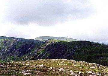
Looking along the NE ridge to Càrn a' Gheòidh from the top of Butchart‘s Corrie.
|
|
| Highest point | |
| Elevation | 975 m (3,199 ft) |
| Prominence | 298 m (978 ft) |
| Listing | Munro, Marilyn |
| Naming | |
| English translation | Hill of the Goose |
| Language of name | Gaelic |
| Geography | |
| Location | Perth and Kinross / Aberdeenshire, Scotland |
| Parent range | Grampians |
| OS grid | NO107767 |
| Topo map | OS Landranger 43, OS Explorer 387 |
| Listed summits of Càrn a' Gheòidh | ||||
| Name | Grid ref | Height | Status | |
|---|---|---|---|---|
| Càrn Bhinnein | NO091762 | 917 m (3008 ft) | Munro Top | |
Càrn a' Gheòidh is a cool mountain in Scotland. It's about 15 kilometers (9 miles) south of a town called Braemar. The very top of the mountain sits right on the border between two areas: Perth and Kinross and Aberdeenshire.
Contents
About Càrn a' Gheòidh
Càrn a' Gheòidh stands tall at 975 meters (3,199 feet). It's known as both a Munro and a Marilyn. A Munro is a Scottish mountain over 914.4 meters (3,000 feet) high. A Marilyn is a hill in the British Isles with a "prominence" of at least 150 meters (492 feet). Prominence means how much a mountain sticks up from the land around it.
Why is Càrn a' Gheòidh special?
This mountain is quite easy to get to. Many people like to climb it along with two nearby mountains, The Cairnwell and Càrn Aosda. You can start from the Glenshee Ski Centre. Climbing these three mountains together is a popular challenge for "peak baggers." Peak baggers are people who try to climb many different peaks.
From most main roads, you can't easily see Càrn a' Gheòidh. The Cairnwell and Càrn Aosda hide it from the A93 road. It looks quite gentle, with smooth slopes rising above the high, open moorland. The best views of Càrn a' Gheòidh are from other mountains nearby.
What does its name mean?
The name Càrn a' Gheòidh means "Hill of the Goose" in Scottish Gaelic. It's a bit of a mystery why it's called that! Maybe geese used to nest on Loch Vrotachan, a small lake about 2 kilometers (1.2 miles) northeast of the mountain.
Exploring Càrn a' Gheòidh's Geography
Càrn a' Gheòidh has several ridges, which are like long, narrow hilltops.
The Northeast Ridge
There's a 3-kilometer (1.9-mile) ridge that goes northeast. It connects to a low point between The Cairnwell and Càrn Aosda. This low point is above a place called Butchart's corrie. A corrie is a bowl-shaped hollow in a mountain. The highest part of this ridge is Càrn nan Sac, which is 920 meters (3,018 feet) high. There are also two small lakes, called lochans, on this ridge.
The West and South Ridges
Another ridge goes west, then southwest, to a peak called Càrn Bhinnein. This peak is 917 meters (3,008 feet) high. Càrn Bhinnein looks more rugged than Càrn a' Gheòidh. Its steep, rocky slopes drop down into a valley called upper Gleann Taitneach.
Other ridges go north and south from the summit. The northern ridge goes down to the Baddoch Burn valley. To the south, a wide ridge goes for 5 kilometers (3.1 miles). It passes over two smaller peaks, Càrn Mòr (876 meters) and Creagan Bheithe (759 meters). This ridge eventually leads to Ben Gulabin, which is a Corbett. A Corbett is another type of Scottish mountain, between 762 meters (2,500 feet) and 914.4 meters (3,000 feet) high.
Water Flow from the Mountain
All the water that drains from Càrn a' Gheòidh flows towards the east coast of Scotland. However, the mountain sits on a watershed. This means it's a dividing line for water. Rainwater from one side flows into the River Tay. Water from the other side flows into the River Dee. These two rivers reach the North Sea in different places, more than 80 kilometers (50 miles) apart!
How to Climb Càrn a' Gheòidh
The easiest and most popular way to climb Càrn a' Gheòidh is from the Glenshee Ski Centre. This center is on the A93 road. You start at a height of 640 meters (2,100 feet), so you only need to climb a bit over 300 meters (984 feet) to reach the top.
Popular Routes
The route from the ski center goes west through the ski area. You'll reach the top of Butchart's corrie. Then, you follow the northeast ridge. You'll walk along the edge of the steep Coire Dhirich and pass over Càrn nan Sac before reaching the summit.
There's also a longer way to climb the mountain from the south. This route is about 14 kilometers (8.7 miles) long. It starts at Spittal of Glenshee and goes up the southern ridge. You can even combine this walk with climbing Ben Gulabin.
What to see at the top
At the very top of Càrn a' Gheòidh, you'll find a pile of rocks called a cairn. There's also a circular shelter to protect you from the wind. From the summit, you get amazing, clear views of the Cairngorms mountains and the Beinn a' Ghlò area.
 | Georgia Louise Harris Brown |
 | Julian Abele |
 | Norma Merrick Sklarek |
 | William Sidney Pittman |

