Cabot, Vermont facts for kids
Quick facts for kids
Cabot, Vermont
|
|
|---|---|

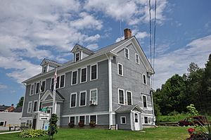
Cabot Town Hall
|
|

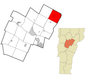
Location in Washington County and the state of Vermont
|
|
| Country | United States |
| State | |
| County | Washington |
| Communities |
|
| Area | |
| • Total | 38.5 sq mi (99.8 km2) |
| • Land | 37.3 sq mi (96.6 km2) |
| • Water | 1.2 sq mi (3.2 km2) |
| Elevation | 1,332 ft (406 m) |
| Population
(2020)
|
|
| • Total | 1,443 |
| • Density | 37.48/sq mi (14.459/km2) |
| Time zone | UTC-5 (Eastern (EST)) |
| • Summer (DST) | UTC-4 (EDT) |
| ZIP Codes | |
| Area code(s) | 802 |
| FIPS code | 50-11125 |
| GNIS feature ID | 1462061 |
Cabot is a small town in the state of Vermont, United States. It is located in the northeast part of Washington County. In 2020, about 1,443 people lived there.
Cabot is made up of several smaller communities. These include Cabot Village, Cabot Plain, South Cabot, East Cabot, Lower Cabot, and West Hill. There was once a community called Petersville. It was flooded in 1925 to create Molly's Falls Reservoir. This reservoir is also known as "Marshfield Dam."
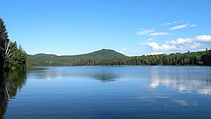
Cabot has several important ponds. Coit's Pond is where the Winooski River begins. Molly's Pond is special because its water flows in two directions. Some water goes east towards the Connecticut River. Other water flows west into the Winooski River and Lake Champlain. West Hill Pond was once a large open field. Joe’s Pond is a big pond shared by Cabot, Walden, and Danville. Molly's Pond State Park covers over 1,000 acres. It includes the 411-acre reservoir. This reservoir helps power a hydroelectric plant nearby.
Cabot is famous for the Cabot Creamery. It started in 1893 as a butter factory. Today, it makes and sells many dairy products. It is especially known for its delicious cheddar cheese. The creamery is Cabot's biggest employer. It has plants in Cabot and other states. It began as a cooperative in 1919 with 94 farmers. Now, only a few dairy farms are left in Cabot. The creamery gets milk from many other towns.
Many former dairy farms in Cabot have changed. They now grow fruit, make maple syrup, or grow vegetables. Some raise beef, sheep, turkeys, or goats. Many artists, writers, and other professionals live in Cabot. They enjoy the beautiful countryside.
Cabot Village is the main hub of the town. It sits by the Winooski River. Here you will find the post office, a church, and the library. The town offices are also here. There is a volunteer fire department and ambulance service. Main Street has a grocery store, a computer shop, and an auto garage. You can also find a bar and a restaurant. Cabot Commons is a housing complex for seniors. It opened in 2005. The former Masonic Lodge Hall is now home to "Neighbors in Action." This group helps the community.
Cabot also has an art barn gallery. It shows art exhibits in the summer. The Cabot Historical Society is open from May to October. It has many old items and books about the town's past. The society keeps a preserved 1849 school building. It also owns a restored one-room schoolhouse on West Hill.
The village common is a busy place. It hosts concerts, farmers' markets, and craft events. In winter, there is a community skating rink. Hiking and snowmobile trails run through the town. Cabot also has a well-kept town forest.
Cabot holds annual town meetings. A group of five people called the selectboard manages the town's business. They meet at least twice a month.
Contents
History of Cabot
The town of Cabot was officially created in 1780. The first settlers arrived in 1783. These included Benjamin Webster and Jonathan Heath. The town was named by Lyman Hitchcock. He named it after his wife, Sophia Cabot. Lyman Hitchcock became the first town clerk in 1788.
An important road, the Bayley-Hazen Military Road, was started in 1775. It was meant to go from Newbury to Quebec, Canada. The goal was to help the army get supplies during the American Revolution. But the road was never finished. Still, it helped open up the northern part of Vermont for new settlers.
Cabot Plain was the main business area until about 1796. Then, town leaders decided to move the center of town. They moved it about a mile south, downhill from the Plain. A meeting house was built there. Over time, business moved again. By 1826, the main activities were in the valley. This new settlement was by the Winooski River. It is where the village is today.
The Town of Cabot officially became a town on November 19, 1866. Communities grew near rivers and ponds. This was because water power was useful for mills. Sawmills and grist mills were common. Lower Cabot even had a woolen mill.
Cabot's Population
| Historical population | |||
|---|---|---|---|
| Census | Pop. | %± | |
| 1800 | 349 | — | |
| 1810 | 686 | 96.6% | |
| 1820 | 1,032 | 50.4% | |
| 1830 | 1,304 | 26.4% | |
| 1840 | 1,440 | 10.4% | |
| 1850 | 1,356 | −5.8% | |
| 1860 | 1,318 | −2.8% | |
| 1870 | 1,279 | −3.0% | |
| 1880 | 1,242 | −2.9% | |
| 1890 | 1,074 | −13.5% | |
| 1900 | 1,126 | 4.8% | |
| 1910 | 1,116 | −0.9% | |
| 1920 | 1,036 | −7.2% | |
| 1930 | 1,107 | 6.9% | |
| 1940 | 974 | −12.0% | |
| 1950 | 826 | −15.2% | |
| 1960 | 763 | −7.6% | |
| 1970 | 663 | −13.1% | |
| 1980 | 958 | 44.5% | |
| 1990 | 1,043 | 8.9% | |
| 2000 | 1,213 | 16.3% | |
| 2010 | 1,433 | 18.1% | |
| 2020 | 1,443 | 0.7% | |
| U.S. Decennial Census | |||
In 2010, Cabot had 1,433 people living there. There were 570 households. Most people were White. About 32.5% of households had children under 18. Most families were married couples. The average household had about 2.5 people.
The population included people of all ages. About 24.7% were under 18. The median age was 43 years old. This means half the people were younger than 43, and half were older.
Schools in Cabot
Each community in Cabot used to have its own school. The very first school was a log cabin. It had no windows and only a fireplace for heat. Students sat on benches and used boards as desks. John Gunn was the first teacher in 1792.
Early schools were built so no student had to walk more than two miles. These buildings had few windows. They also had no electricity or indoor plumbing. A large iron stove provided heat. Each school had an outhouse. Students shared a bucket of water for drinking. Teachers were sometimes men who taught for a few weeks. Sometimes, young women in town taught. Male teachers were always paid more than female teachers.
The Cabot Plains School was built in 1923. It was the town's first "Standard School." This new building had central heating, water, electricity, and toilets. Another "Standard School" was built in South Cabot in 1930. These schools usually had one teacher. They taught up to thirty students across all eight grades. Today, both of these schools are private homes. The West Hill school is owned by the Cabot Historical Society. It is open for tours on special days.
Cabot's one-room schools closed over time. This happened as the number of farms and people changed. It became too expensive to keep small schools open for only a few students. Better roads and cars also made it easier to travel. The schools in Lower Cabot, Cabot Plain, and East Cabot closed in 1948. The South Cabot school closed in 1954.
Children then started taking buses to the Cabot Village School. This school was built in 1938. It used to serve grades one through twelve. Today, it serves students from pre-kindergarten all the way to twelfth grade. It is one of the few schools in Vermont that teaches all these grades together. The school campus has a gym and a performing arts center. There are also separate buildings for elementary students. Two recreation fields are close by.
Cemeteries
Cabot has seven cemeteries. Each small community had its own burial ground. The first official cemetery was started in 1799. It is at the center of town. William Osgood, a town clerk, was the first person buried there in 1801. This cemetery has 89 known burials. At least eight veterans from the Revolutionary War are buried there.
Other cemeteries include Durant Cemetery in Lower Cabot (1812-present). Kimball Cemetery (1814) was a small site. It was replaced by the West Hill Cemetery (1817-present). The Cabot Village Cemetery (1820-present) is also known as Elm Street Cemetery. Other cemeteries are Cabot Plains (1825-present), South Cabot (1834-present), and East Cabot (1847-present). Durant Cemetery has a "Sunken Garden" near the Winooski River. Cabot Plains Cemetery offers views of mountains like Camel's Hump and Jay Peak. West Hill cemetery is located on a working farm. The Center Cemetery is in a remote area among tall pine trees.
Historic Sites
The historic Bayley-Hazen Road crosses Cabot Plain. It starts near the Danville-Cabot town line. It then goes northwest into Walden. The road ends at Hazen’s Notch in Lowell, Vermont. This road was planned to help America's Continental Army. It would have provided a shorter way to get supplies during the American Revolution in 1776.
Colonel Jacob Bayley suggested the road in 1776. Thomas Johnson and his team explored the path. Johnson thought the new road would save 73 miles. George Washington, the army's leader, agreed to the plan. Work began in the summer of 1776. But the army was defeated, so the road was no longer needed for military purposes. Bayley and his men stopped working on Cabot Plain.
In 1778, there were plans for another invasion. General Moses Hazen was sent to finish the road. But it became clear that the British could use the road to enter Vermont. There were some small fights. By the end of 1779, work stopped completely. The road was never finished past Hazen’s Notch.
Today, there are markers on Cabot Plain. They show where the military road was. They also mark Hazen's camp site.
Climate and Weather
Cabot has a typical northern Vermont climate. The growing season for plants is usually short. Winters can be very cold with lots of snow. Temperatures often stay below zero for long periods. Summers are usually mild. The weather can change often. Because Cabot has many hills, it can experience floods. This is especially true in Cabot Village. The hilly areas can also have strong winds.
Notable People
- Zerah Colburn, a math genius
- Carlos Everett Conant, a professor and linguist
- Edward M. Doe, a judge in Arizona
- Peter Gray, a psychologist and author
- Luis Guzmán, an actor who lives in Cabot
- John H. Senter, a lawyer and mayor of Montpelier, Vermont
- Ellen Bryant Voigt, a poet and teacher
- Will Voigt, a basketball coach for the 2016 Nigerian Olympic team
- Charles Carroll Webster, a Minnesota state senator and lawyer
See also
 In Spanish: Cabot (Vermont) para niños
 | Bayard Rustin |
 | Jeannette Carter |
 | Jeremiah A. Brown |


