Calhoun Falls, South Carolina facts for kids
Quick facts for kids
Calhoun Falls, South Carolina
|
|
|---|---|

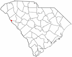
Location of Calhoun Falls, South Carolina
|
|
| Country | United States |
| State | South Carolina |
| County | Abbeville |
| Area | |
| • Total | 3.46 sq mi (8.96 km2) |
| • Land | 3.39 sq mi (8.77 km2) |
| • Water | 0.07 sq mi (0.19 km2) |
| Elevation | 525 ft (160 m) |
| Population
(2020)
|
|
| • Total | 1,727 |
| • Density | 509.89/sq mi (196.86/km2) |
| Time zone | UTC-5 (Eastern (EST)) |
| • Summer (DST) | UTC-4 (EDT) |
| ZIP code |
29628
|
| Area codes | 864, 821 |
| FIPS code | 45-10720 |
| GNIS feature ID | 1247089 |
Calhoun Falls is a small town in Abbeville County, South Carolina, United States. In 2020, about 1,727 people lived there. The town is named after James Edward Colhoun (or Calhoun).
Contents
Where is Calhoun Falls Located?
Calhoun Falls is found in South Carolina. Its exact location is 34°5′34″N 82°35′23″W / 34.09278°N 82.58972°W.
Nearby Natural Areas
The town is close to several beautiful natural spots.
- The Calhoun Falls State Park is less than 1 mile away. It is a South Carolina state park.
- The Calhoun Falls State Recreation Area is also nearby.
- Lake Richard B. Russell is about 3 miles west. This large lake is on the border between Georgia and South Carolina.
- Bobby Brown State Park, a Georgia state park, is about 5 miles away.
Roads and Travel
Calhoun Falls is at a meeting point for two main South Carolina highways. These are South Carolina Highway 72 and South Carolina Highway 81.
- Highway 72 connects the town to cities like Elberton, Georgia, Athens, Georgia, and Atlanta to the west. To the east, it links to Abbeville, Greenwood, and the Charlotte area.
- Highway 81 connects Calhoun Falls to Anderson in the north and McCormick in the south.
Recently, Highway 72 was changed to go around downtown Calhoun Falls. This new route is a four-lane bypass.
Land and Water
The town covers an area of about 9 square kilometers (3.46 square miles). Most of this area, about 8.8 square kilometers (3.39 square miles), is land. A small part, about 0.2 square kilometers (0.07 square miles), is water.
Schools in Calhoun Falls
Calhoun Falls has public schools for its students.
- John C. Calhoun Elementary School teaches younger students.
- Calhoun Falls Charter School was started in 2008. It is a charter school, which means it has more freedom in how it operates.
Before 2008, the town had Calhoun Falls High School. This school was part of the Abbeville County School District. It closed due to budget problems. Local town leaders then started the Calhoun Falls Charter School. It is located in the same building as the old high school.
Public Library
The town also has a public library. It is a part of the Abbeville County Library System.
Who Lives in Calhoun Falls?
The population of Calhoun Falls was 1,727 people in 2020. This number was counted during the 2020 United States census. The town had 742 households and 417 families living there.
Population Over Time
The number of people living in Calhoun Falls has changed over many years.
| Historical population | |||
|---|---|---|---|
| Census | Pop. | %± | |
| 1910 | 296 | — | |
| 1920 | 807 | 172.6% | |
| 1930 | 1,759 | 118.0% | |
| 1940 | 1,832 | 4.2% | |
| 1950 | 2,396 | 30.8% | |
| 1960 | 2,525 | 5.4% | |
| 1970 | 2,234 | −11.5% | |
| 1980 | 2,491 | 11.5% | |
| 1990 | 2,328 | −6.5% | |
| 2000 | 2,303 | −1.1% | |
| 2010 | 2,004 | −13.0% | |
| 2020 | 1,726 | −13.9% | |
| 2022 (est.) | 1,726 | −13.9% | |
| U.S. Decennial Census | |||
Different Backgrounds
People from many different backgrounds live in Calhoun Falls.
| Group | Number | Percentage |
|---|---|---|
| White (not Hispanic) | 661 | 38.27% |
| Black or African American (not Hispanic) | 951 | 55.07% |
| Native American | 8 | 0.46% |
| Asian | 4 | 0.23% |
| Other/Mixed | 70 | 4.05% |
| Hispanic or Latino | 33 | 1.91% |
Famous People from Calhoun Falls
Some well-known people have come from Calhoun Falls.
- Kelly Bryant is a football quarterback. He played for the Missouri Tigers.
- Martavis Bryant is a wide receiver in the National Football League (NFL). He played for the Washington Commanders.
- Neil Chrisley was a Major League Baseball outfielder.
See also
 In Spanish: Calhoun Falls para niños
 | Frances Mary Albrier |
 | Whitney Young |
 | Muhammad Ali |

