Abbeville, South Carolina facts for kids
Quick facts for kids
Abbeville, South Carolina
|
||
|---|---|---|
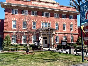
Abbeville Opera House (2003)
|
||
|
||
| Country | United States | |
| State | South Carolina | |
| County | Abbeville | |
| Area | ||
| • Total | 6.23 sq mi (16.13 km2) | |
| • Land | 6.21 sq mi (16.10 km2) | |
| • Water | 0.01 sq mi (0.03 km2) | |
| Elevation | 594 ft (181 m) | |
| Population
(2020)
|
||
| • Total | 4,874 | |
| • Density | 784.23/sq mi (302.77/km2) | |
| Time zone | UTC−5 (Eastern (EST)) | |
| • Summer (DST) | UTC−4 (EDT) | |
| ZIP code |
29620
|
|
| Area codes | 864, 821 | |
| FIPS code | 45-00100 | |
| GNIS feature ID | 1244839 | |
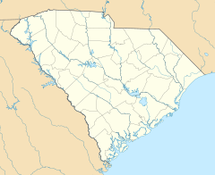
Abbeville is a city in South Carolina, USA. It is the main city of Abbeville County.
The city is about 86 miles (138 km) west of Columbia. It is also 45 miles (72 km) south of Greenville. In 2010, about 5,237 people lived there. French settlers called Huguenots first lived here. They named the city and county after a town in France with the same name.
Contents
History of Abbeville
Abbeville was started in 1764 by French Huguenots. It became an official town in 1840.
John C. Calhoun, a famous American Vice President, worked as a lawyer in Abbeville. He was born on a farm nearby.
Abbeville and the Civil War
Abbeville is known as both the start and end point for the Confederacy. On November 22, 1860, a meeting took place at a spot called "Secession Hill". Here, people decided South Carolina should leave the United States. One month later, South Carolina was the first state to leave the Union.
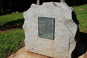
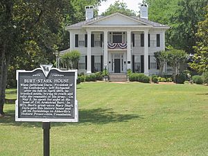
At the end of the Civil War, the Confederacy was falling apart. Confederate President Jefferson Davis left Richmond, Virginia, and traveled south. He stayed one night in Abbeville at the home of his friend, Armistead Burt. On May 2, 1865, in the Burt-Stark Mansion, Jefferson Davis said the Confederate government was officially over. This was the last official meeting of his cabinet.
Important Buildings in Abbeville
Many buildings in Abbeville are listed on the National Register of Historic Places. These include the Abbeville County Courthouse and the Abbeville Opera House. The Armistead Burt House and Trinity Episcopal Church and Cemetery are also on the list.
Abbeville is also home to the tallest building in South Carolina. It is the Prysmian Copper Wire Tower. This tower was built in 2009. It is 373 feet (114 meters) tall and has 30 floors.
Geography and Climate
Abbeville is located in the Piedmont Upland area. The city has a total area of about 6.2 square miles (16.1 square kilometers). Most of this area is land.
The Sumter National Forest is located nearby.
Weather in Abbeville
Abbeville has a humid subtropical climate. This means it has cool winters and hot, humid summers. Spring and fall are usually warm.
In summer, temperatures often reach the mid-90s Fahrenheit (around 35°C). Sometimes, it gets over 100°F (38°C). The highest temperature ever recorded was 109°F (43°C) on July 1, 2012.
In winter, high temperatures are usually in the low to mid-50s Fahrenheit (around 10-13°C). Lows are usually around freezing. Snow is rare, falling only every few years.
Rainfall is spread out throughout the year. In summer, thunderstorms are common. These can bring strong winds and lightning.
On March 31, 1973, a strong tornado hit Abbeville. It killed 7 people. In April 2009, two more tornadoes struck the area. No one died, but many buildings were damaged.
| Climate data for Abbeville, SC | |||||||||||||
|---|---|---|---|---|---|---|---|---|---|---|---|---|---|
| Month | Jan | Feb | Mar | Apr | May | Jun | Jul | Aug | Sep | Oct | Nov | Dec | Year |
| Record high °F (°C) | 82 (28) |
80 (27) |
89 (32) |
92 (33) |
97 (36) |
105 (41) |
109 (43) |
107 (42) |
104 (40) |
100 (38) |
89 (32) |
78 (26) |
109 (43) |
| Mean daily maximum °F (°C) | 53 (12) |
58 (14) |
66 (19) |
74 (23) |
82 (28) |
88 (31) |
91 (33) |
90 (32) |
84 (29) |
74 (23) |
65 (18) |
55 (13) |
73 (23) |
| Mean daily minimum °F (°C) | 31 (−1) |
34 (1) |
40 (4) |
48 (9) |
57 (14) |
66 (19) |
70 (21) |
69 (21) |
62 (17) |
50 (10) |
41 (5) |
33 (1) |
50 (10) |
| Record low °F (°C) | −2 (−19) |
2 (−17) |
3 (−16) |
24 (−4) |
32 (0) |
41 (5) |
53 (12) |
50 (10) |
35 (2) |
25 (−4) |
13 (−11) |
1 (−17) |
−2 (−19) |
| Average precipitation inches (mm) | 4.16 (106) |
4.60 (117) |
4.68 (119) |
2.85 (72) |
3.40 (86) |
3.45 (88) |
4.01 (102) |
3.68 (93) |
3.11 (79) |
3.45 (88) |
3.62 (92) |
3.76 (96) |
44.77 (1,137) |
People of Abbeville
| Historical population | |||
|---|---|---|---|
| Census | Pop. | %± | |
| 1850 | 1,252 | — | |
| 1860 | 592 | −52.7% | |
| 1880 | 1,543 | — | |
| 1890 | 1,696 | 9.9% | |
| 1900 | 3,766 | 122.1% | |
| 1910 | 4,459 | 18.4% | |
| 1920 | 4,570 | 2.5% | |
| 1930 | 4,414 | −3.4% | |
| 1940 | 4,930 | 11.7% | |
| 1950 | 5,395 | 9.4% | |
| 1960 | 5,436 | 0.8% | |
| 1970 | 5,515 | 1.5% | |
| 1980 | 5,833 | 5.8% | |
| 1990 | 5,778 | −0.9% | |
| 2000 | 5,840 | 1.1% | |
| 2010 | 5,237 | −10.3% | |
| 2020 | 4,874 | −6.9% | |
| 2022 (est.) | 4,859 | −7.2% | |
| U.S. Decennial Census | |||
Abbeville first appeared in the US Census in 1850. At that time, 1,252 people lived there.
Population in 2020
| Race | Num. | Perc. |
|---|---|---|
| White (non-Hispanic) | 2,377 | 48.77% |
| Black or African American (non-Hispanic) | 2,274 | 46.66% |
| Native American | 5 | 0.1% |
| Asian | 7 | 0.14% |
| Other/Mixed | 159 | 3.26% |
| Hispanic or Latino | 52 | 1.07% |
In 2020, there were 4,874 people living in Abbeville. There were 2,256 households and 1,294 families.
Economy of Abbeville
Farming and forestry are important jobs in the Abbeville area. Farmers grow crops like cotton, corn, wheat, and hay. They also raise animals like cows and chickens.
In the past, making clothes was a main industry. However, after the North American Free Trade Agreement, clothing is no longer made in Abbeville. Today, plastic and metal products are also made here.
Education in Abbeville
Abbeville is part of the Abbeville County School District. The city has several schools for different age groups. These include Long Cane Primary, Westwood Elementary, and J.S. Wright Middle School. For high school, students attend Dixie High or Abbeville High.
Abbeville also has a public library. It is a part of the Abbeville County Library System. There are also colleges nearby, such as Piedmont Tech, Lander, and Erskine.
Arts and Culture
Abbeville Gypsy Dessert
Abbeville is famous for a special holiday dessert called Gypsy. Gypsy is a pudding made with pound cake or sponge cake. It also has boiled custard, sherry (or bourbon), whipping cream, and almonds.
It is similar to an English trifle. Some people call it "tipsy pudding" or "southern tiramisu". Families in Abbeville often make Gypsy for Thanksgiving or Christmas. It is usually served in a special glass bowl.
The recipe for Gypsy dates back to the late 1800s. There is a story that an unknown woman served Gypsy to Confederate President Jefferson Davis in 1865.
Famous People from Abbeville
- Christie Benet (1879–1951) - A U.S. Senator for South Carolina.
- John C. Calhoun (1782–1850) - The 7th American Vice President. He also served as the 16th U.S. Secretary of State. He was born near Abbeville and worked as a lawyer there.
- James S. Cothran (1830–1897) - Born near Abbeville, he was a lawyer, Confederate officer, and United States Congressman.
- Thomas D. Howie (1908–1944) - An American army officer known as "The Major of St. Lo." He was killed during World War II while trying to capture a French town.
- Samuel McGowan (general) (1819–1897) - A Confederate General and later a South Carolina Supreme Court justice.
- Mary Elizabeth Moragne Davis (1815–1903) - A diarist and writer.
- Benjamin Glover Shields (1808–1850) - Born in Abbeville, he was a United States Congressman from Alabama.
See also
 In Spanish: Abbeville (Carolina del Sur) para niños
 | Georgia Louise Harris Brown |
 | Julian Abele |
 | Norma Merrick Sklarek |
 | William Sidney Pittman |


