Camas County, Idaho facts for kids
Quick facts for kids
Camas County
|
||
|---|---|---|

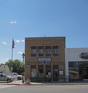
Camas County Courthouse in Fairfield
|
||
|
||

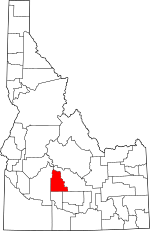
Location within the U.S. state of Idaho
|
||
 Idaho's location within the U.S. |
||
| Country | ||
| State | ||
| Founded | February 6, 1917 | |
| Named for | Camas root | |
| Seat | Fairfield | |
| Largest city | Fairfield | |
| Area | ||
| • Total | 1,079 sq mi (2,790 km2) | |
| • Land | 1,074 sq mi (2,780 km2) | |
| • Water | 4.5 sq mi (12 km2) 0.4% | |
| Population
(2020)
|
||
| • Total | 1,077 | |
| • Estimate
(2022)
|
1,153 |
|
| • Density | 1/sq mi (0.4/km2) | |
| Time zone | UTC−7 (Mountain) | |
| • Summer (DST) | UTC−6 (MDT) | |
| Congressional district | 2nd | |
Camas County is a county in the southern part of Idaho. The main town and county seat is Fairfield. A county seat is where the local government offices are. The county was created in 1917 by the Idaho Legislature. It was formed from a part of Blaine County.
Camas County is named after the camas root. This is a lily-like plant with an edible bulb. Native Americans and early settlers used it for food. In 2020, about 1,077 people lived here. This makes it one of the smallest counties in Idaho. Camas County is also part of the Hailey, ID Micropolitan Statistical Area. This means it's connected to a larger urban area for jobs and services.
Contents
History of Camas County
People have lived on the Camas Prairie for over 11,000 years. The Shoshoni, Northern Piute, and Nez Perce tribes visited yearly. They gathered camas and yampa plants for winter food. An explorer named Donald Mackenzie found the Camas Prairie around 1820. The area slowly became an important travel route.
In 1852, soldiers started using this route. They escorted wagon trains heading to Oregon. This path was later called Goodale Cutoff. Timothy Goodale first led migrants through here in 1862. The southern part of the Camas Prairie was important for army horses.
In 1869, a treaty was made with the Bannock Indians. It was supposed to protect their rights to the "Camas Prairie." But a mistake in the treaty said "Kansas Prairie" instead. Because there was no "Kansas Prairie" in Idaho, the Bannocks' rights were ignored. When settlers let their hogs eat the camas roots, the Bannocks protested. This conflict was a major reason for the Bannock War of 1878.
After the Bannock War, more settlers arrived. The first settlements were mostly farms. By 1881, there were over 60 farms. Towns like Crichton and Soldier started around 1884. Corral was settled by 1886. A railroad came to the Camas Prairie in 1911. It went through the area that is now Fairfield. This led many people from Soldier to move to Fairfield.
Geography of Camas County
Camas County covers about 1,079 square miles. Most of this area is land. Only a small part is water. The highest point in the county is Camas County Highpoint. It is about 10,337 feet tall. This peak is on the border with Blaine County.
Neighboring Areas
Camas County shares its borders with these other counties:
- Blaine County to the east
- Lincoln County to the southeast
- Gooding County to the south
- Elmore County to the west
People and Population
| Historical population | |||
|---|---|---|---|
| Census | Pop. | %± | |
| 1920 | 1,730 | — | |
| 1930 | 1,411 | −18.4% | |
| 1940 | 1,360 | −3.6% | |
| 1950 | 1,079 | −20.7% | |
| 1960 | 917 | −15.0% | |
| 1970 | 728 | −20.6% | |
| 1980 | 818 | 12.4% | |
| 1990 | 727 | −11.1% | |
| 2000 | 991 | 36.3% | |
| 2010 | 1,117 | 12.7% | |
| 2020 | 1,077 | −3.6% | |
| 2023 (est.) | 1,232 | 10.3% | |
| U.S. Decennial Census 1790–1960, 1900–1990, 1990–2000, 2010–2020 |
|||
Population in 2020
In 2020, there were 1,077 people living in Camas County.
Population in 2010
In 2010, the county had 1,117 people. There were 487 households. Most people were white (94.1%). Some people were American Indian, Black, or Asian. About 6.7% of the population was of Hispanic or Latino origin. Many residents had German, American, English, Irish, or Swedish backgrounds.
Towns and Communities
City
Unincorporated communities
These are smaller communities without their own city government:
Getting Around
U.S. Highway 20 goes through the middle of the county. It runs from east to west. This highway connects Camas County to Mountain Home in Elmore County. To the east, it meets State Highway 75 in Blaine County.
State Highway 46 starts near Fairfield. It goes south over the Mount Bennett Hills. This highway leads to Gooding County and the town of Gooding.
Fun Things to Do
The Soldier Mountain ski area is a popular spot. It opened in 1948. It is about 12 miles north of Fairfield. You can find it in the Soldier Mountains. These mountains are part of the Sawtooth National Forest.
Schools
Camas County has one school district. It is called Camas County School District 121. The county is also part of the area served by the College of Southern Idaho.
See also
 In Spanish: Condado de Camas para niños
 | George Robert Carruthers |
 | Patricia Bath |
 | Jan Ernst Matzeliger |
 | Alexander Miles |


