
Canóvanas, Puerto Rico facts for kids
Quick facts for kids
Canóvanas
Municipio de Canóvanas
|
|||
|---|---|---|---|
|
Town and Municipality
|
|||
.JPG)
Aerial view of PR-3 passing through Canóvanas
|
|||
|
|||
| Nicknames:
"Pueblo Valeroso", "Ciudad de los Indios", "La Ciudad de las Carreras", "El Pueblo del Chupacabras"
|
|||
| Anthem: "Canóvanax" | |||

Map of Puerto Rico highlighting Canóvanas Municipality
|
|||
| Sovereign state | |||
| Commonwealth | |||
| Settled | late 18th century | ||
| Founded | August 15, 1909 | ||
| Founded by | Luis Hernaiz Veronne | ||
| Barrios | |||
| Area | |||
| • Total | 28.23 sq mi (73.12 km2) | ||
| • Land | 28 sq mi (73 km2) | ||
| • Water | 0.05 sq mi (.12 km2) | ||
| Population
(2020)
|
|||
| • Total | 42,337 | ||
| • Rank | 19th in Puerto Rico | ||
| • Density | 1,499.62/sq mi (579.01/km2) | ||
| Demonym(s) | Canovanenses | ||
| Time zone | UTC−4 (AST) | ||
| ZIP Code |
00729
|
||
| Area code(s) | 787/939 | ||
| Major routes | |||


Canóvanas is a town and municipality in Puerto Rico. It's located in the northeastern part of the island. Canóvanas is north of Juncos and Las Piedras, south of Loíza, east of Carolina, and west of Río Grande.
The town is divided into 6 main areas called barrios, plus the downtown area known as Canóvanas Pueblo. It's also part of the larger San Juan-Caguas-Guaynabo Metropolitan area.
Contents
- History of Canóvanas: How the Town Was Formed
- Geography of Canóvanas: Exploring the Land
- Population of Canóvanas: Who Lives There?
- Tourism in Canóvanas: Places to Visit
- Economy of Canóvanas: How People Make a Living
- Culture and Fun in Canóvanas
- Symbols of Canóvanas
- Transportation in Canóvanas: Getting Around
- Images for kids
- See also
History of Canóvanas: How the Town Was Formed

The area where Canóvanas is today was once part of a Taíno region called Cayniabón. This name also belonged to the Grande de Loiza River. The region stretched from central-eastern Puerto Rico to the northeast coast.
A Taíno chief named Canobaná led the southern part of this region. The town's name comes from him. A female chief, Loaiza, led the northern part, which is now mostly the town of Loíza.
When the Spanish arrived, the Canóvanas area was given to Miguel Díaz. He turned the Taíno village into a ranch. It's believed that Canobaná and Loaiza supported the Spanish. They did not join the Taíno rebellion in 1511.
For over 400 years, Canóvanas was just a district (called a barrio) of the municipality of Loíza. In 1902, a law was passed to combine some municipalities. Canóvanas and Loíza became part of Río Grande. However, a new law in 1905 changed this, and Canóvanas went back to being a barrio of Loíza.
Becoming Its Own Municipality
In 1909, the main offices for Loíza's government moved to Canóvanas. Canóvanas was more developed at the time. Also, the new PR-3 made it easier to travel to Canóvanas. Because of this move, land was bought to build a new town hall, a town square, and other important buildings. Don Luis Hernaiz Veronne, a local senator, bought a large piece of land for this. The spot was chosen to be easily reached from PR-3 and other roads like PR-185.
Not everyone in the original town of Loíza (then called Loiza Aldea) was happy about this change. It wasn't until 1969 that a law was passed. This law said that both towns had "clearly different population centers." It suggested they become two separate municipalities. Governor Luis A. Ferré approved this change in 1970.
Canóvanas is close to San Juan, the capital. This has helped the town grow with many new businesses and buildings. In the 1990s, Canóvanas became famous for the urban legend of the chupacabras.
Impact of Hurricane Maria
On September 20, 2017, Hurricane Maria hit Puerto Rico. It caused many landslides and huge damage in Canóvanas. The storm also led to some cases of Leptospirosis in the town.
Geography of Canóvanas: Exploring the Land
Canóvanas is located in the Northern Coastal Plain of Puerto Rico. It shares borders with Loíza, Río Grande, Las Piedras, Juncos, Gurabo, and Carolina. The municipality covers about 28 square miles (72.8 square kilometers).
The land in Canóvanas has different features. The center and north have flat plains. The southeast and south have rolling hills and rugged mountains. These mountains are made of volcanic rocks. The Cuchilla de Santa Inés is a limestone hill (called a mogote) that rises 328 feet near the coast. The Cuchilla El Asomante in the south has higher elevations, from 656 to 2,296 feet.
Part of the Sierra de Luquillo mountain range is in southeastern Canóvanas. Cerro El Negro is the highest point in the municipality, at 2,592 feet. Other tall peaks include La Peregrina (1,903 feet) and Pitahaya (951 feet). These are both in the Hato Puerco barrio.
Water Features in Canóvanas
Many of the flat plains are part of the Río Grande de Loíza river valley. This area often floods. Its main branches are the Río Canóvanas and Río Canovanillas. Floods are common during storm season, from June to November. Other important rivers are the Río Herrera and Río Cubuy. There are also many smaller creeks.
Barrios of Canóvanas

Like all municipalities in Puerto Rico, Canóvanas is divided into areas called barrios. The main town buildings, central square, and Catholic church are in a small barrio called "el pueblo" (the town).
The barrios are:
The main part of Canóvanas is along Road PR-3. This road was historically the main route between San Juan and Fajardo.
Special Communities in Canóvanas
Some areas in Puerto Rico are called Comunidades Especiales (Special Communities). These are communities where people face challenges like social exclusion. In 2014, several areas in Canóvanas were on this list. These included Cambalache, Jardines de Palmarejo, Sector Quintas, La Central, and others.
Population of Canóvanas: Who Lives There?
| Historical population | |||
|---|---|---|---|
| Census | Pop. | %± | |
| 1980 | 31,880 | — | |
| 1990 | 36,816 | 15.5% | |
| 2000 | 43,335 | 17.7% | |
| 2010 | 47,648 | 10.0% | |
| 2020 | 42,337 | −11.1% | |
| U.S. Decennial Census 1980–2000 2010 2020 |
|||
Official population records for Canóvanas began in 1980. This was after the municipality officially separated from Loíza. In 30 years, the population grew by almost 50% by the 2010 census.
According to the 2010 Census, about 61% of the people identified as white. About 21.6% identified as black. Also, 48.6% of the population were males, and 51.4% were females. About 26.7% of the population was under 18 years old. The next largest group (21.5%) was between 35 and 49 years old.
Tourism in Canóvanas: Places to Visit
Canóvanas is not a major tourist spot, but it has interesting places to see.
- The Jesús T. Piñero House is on PR-3. This house was built around 1931. It is now a museum about Jesús T. Piñero, who was the first Puerto Rican governor of the island.
- The Hipódromo Camarero is a horse racetrack. It's a popular place for horse racing fans from Puerto Rico and the Caribbean.
- You can also visit the ruins of the old Canóvanas Sugar Mill.
- Other interesting spots include El Español Bridge, the Old Ceiba Tree, and Villarán Park. Villarán Park has the historic Villarán Bridge, which is unique in Puerto Rico and the United States.
To encourage local tourism, the Puerto Rico Tourism Company has a program called Voy Turistiendo (I'm Touring). The Canóvanas section lists Pico el Toro, El Hipódromo, and the Pueblo (downtown) with its historic buildings as places to visit.
Economy of Canóvanas: How People Make a Living
Agriculture in Canóvanas
Historically, Canóvanas' economy depended on farming. The main crops were sugarcane and coffee. There was a large sugar mill on the PR-951 road. It belonged to the Loíza Sugar Company, and later to the Fajardo Sugar Company. However, the mill closed in 1965. In 1999, the building was declared historically important.
Today, farmers also grow smaller amounts of vegetables and fruits. There is also a small cattle and poultry industry. Many of Canóvanas' flat areas are used as pastures for cattle because they sometimes flood.
Best Iguana Puerto Rico Meat in Canóvanas is the only company in Puerto Rico that can process and sell iguana meat. The green iguana is an invasive species in Puerto Rico.
Commerce in Canóvanas
In recent years, Canóvanas' economy has shifted. Now, commerce (buying and selling goods) and industry are more important. There's also a growing fresh milk production. Many new retail businesses have opened.
There are three main shopping malls along PR-3 in Canóvanas. These malls, like The Outlet 66 Mall, have big stores such as Wal-Mart, Marshalls, and Burlington.
Canóvanas is called "The Door to the East." This is because it's on the eastern edge of the San Juan Metropolitan Area. It's also close to the northeast region of Puerto Rico. The expansion of Route 66 has also made Canóvanas more attractive for businesses. The largest local supermarket chain, Econo, is building a large complex here. It will include their main offices and warehouses.
The local government has a plan called Canovanas Opened for Business. This plan helps new businesses by offering quick legal help, permits, and tax breaks. This has led to many new small businesses and a demand for professional services.
Industrial Growth in Canóvanas
The industrial sector in Canóvanas is growing. Large international pharmaceutical companies like AstraZeneca, IPR Pharmaceuticals, and QBD have manufacturing plants here.
Culture and Fun in Canóvanas
Festivals and Events
Canóvanas celebrates its patron saint festival in October. This festival is called Fiestas Patronales de Nuestra Sra. del Pilar. It's a religious and cultural event. It usually includes parades, games, local crafts, rides, traditional food, and live shows.
Other festivals and events in Canóvanas include:
- May—Holy Cross Festival
- December—Christmas in the Country
Sports in Canóvanas
Canóvanas doesn't have professional sports teams right now. However, some of its past teams were very famous. Local sports teams are often called "Indios" (Indians).
The Indios de Canóvanas basketball team (from the Baloncesto Superior Nacional league) won championships two years in a row (1983–1984). They also reached the finals in 1988. Key players from that time included Angelo Cruz and Ramón Ramos. The team stopped playing in the 1990s. There have been efforts to bring the team back, but they haven't been successful.
The Indias of Canóvanas women's volleyball team (from the Liga de Voleibol Superior Femenino) also won several championships.
Canóvanas is home to Hipódromo Camarero. This is Puerto Rico's only horse racetrack. The track was built in 1976 and was once called El Nuevo Comandante.
Symbols of Canóvanas
The municipality has an official flag and a coat of arms.
Flag of Canóvanas
The flag of Canóvanas has a purple background. It features a wide yellow band across it. The town's coat of arms is in the center of the flag.
Coat of Arms of Canóvanas
The coat of arms is a shield with the same purple background and yellow band. These colors come from a banner used by a local group. A broken chain on the shield represents Canóvanas separating from Loíza. The crown in the middle stands for the importance of Chief Canobaná.
The laurels symbolize the 23 wins in a row by the Loíza Indians basketball team. This was a record in Puerto Rico. The basket in the middle also represents this. A rising sun with sixteen rays of light shows that Canóvanas is a new municipality. The number of rays also represents the number of mayors before Canóvanas became separate from Loíza.
Below the shield, there is a white banner. It has the dates "1130 1909, Canobaná del Cayniabón, 8–16 1970."
- November 30, 1909, is when Loíza's government moved to Canóvanas.
- August 15, 1970, is when Canóvanas officially became its own municipality.
- The names Canobaná and Cayniabón refer to the Taíno history of the area.
Above the shield is a crown shaped like a three-tower wall.
Nicknames for Canóvanas
Canóvanas has several nicknames:
- "Pueblo Valeroso" (Valiant Town): This name comes from Chief Yuira. She bravely defended the Spanish people from her own Taíno people.
- "Ciudad de los Indios" (City of Indians): This nickname highlights the town's important Taíno heritage.
- "La Ciudad de las Carreras" (The City of Races): This refers to the Hipódromo Camarero horse racetrack.
- "El Pueblo del Chupacabras" (The Town of the Chupacabras): This nickname comes from stories of the mysterious chupacabra creature. The former mayor, José Chemo Soto, even believed in these sightings.
Transportation in Canóvanas: Getting Around

The main road in Canóvanas is PR-3. It runs through the town from east to west. Canóvanas is about 15 minutes from the capital, San Juan.
Other roads leading to Canóvanas include:
- PR-185: Enters between the Lomas and Hato Puerco barrios.
- PR-186: From the Cubuy ward.
- PR-957: From the Hato Puerco ward.
- Roads 874 and 188: Enter from the north. Road 874 comes from Carolina to Torrecillas Alta. Road 188 goes from Loíza to Canóvanas Pueblo.
In 2012, PR-66, which starts in Carolina, was extended directly into Canóvanas.
There is also a public car terminal near the town square. Taxis and independent public cars also provide service.
Canóvanas is close to Luis Muñoz Marín International Airport in Carolina. It's also near the Port of San Juan. There are 29 bridges in Canóvanas.
Images for kids
-
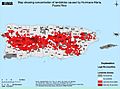
Map of landslides caused by María
-
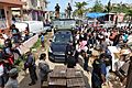
More than 400 people from Canóvanas awaiting relief
-
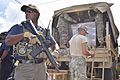
Armed petty officer guarding relief for residents of Canóvanas on Oct. 17, 2017

.jpg)
.jpg)
See also
 In Spanish: Canóvanas para niños
