
Capitol Mall facts for kids
| Capitol Mall Boulevard | |

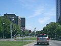
Westward view of the Capitol Mall
|
|
| Maintained by | Sacramento, California |
|---|---|
| Coordinates | 38°34′43″N 121°30′06″W / 38.57865°N 121.50164°W |
| West end | Tower Bridge |
| East end | 10th Street |
.jpg)
The Capitol Mall is a main street and a beautiful, tree-lined road in Sacramento, California. Sacramento is the capital city of California. This important road used to be called M Street. It connects West Sacramento to downtown Sacramento. The Capitol Mall starts at the Tower Bridge and goes all the way east to the California State Capitol building.
Contents
Exploring Capitol Mall's Path
Capitol Mall begins right after you cross the Tower Bridge. This bridge goes over the Sacramento River. As you travel east, you'll pass the Riverfront Promenade park. The road then goes over Interstate 5 before reaching the California State Capitol building.
Many important businesses and law firms in Sacramento are located along Capitol Mall. Because of Sacramento's old street layout, Capitol Mall was once known as M Street. In 1928, Governor C. C. Young renamed it Capitol Avenue. For a while, it was even part of a state highway, State Route 275. But since 2006, the city of Sacramento has been in charge of the road.
A Look Back: Capitol Mall's History


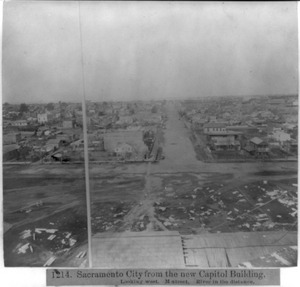
California became a state in 1850. After a few other cities, Sacramento was chosen as the state capital in 1854. The first plans for the Capitol building in 1860 only included a small area.
M Street became very important because it was a main path for visitors coming to the Capitol. They arrived by train at the Central Pacific Railroad station or by riverboat in Old Sacramento. As cars became popular, people realized how important the view of the Capitol from the river was. In 1907, an urban planner named Charles Mulford Robinson suggested making M Street a grand mall, similar to the National Mall in Washington, D.C.
Over the years, many buildings were constructed between M Street and the river. This blocked the view of the Capitol. A city planner even noted that you couldn't see the Capitol from the sidewalks of M Street. He said clearing this area was very important for Sacramento's future.
In 1929, Governor C. C. Young pushed again to widen M Street into a grand mall. He wanted it to be like "the Pennsylvania Avenue of California." He also suggested renaming it Capitol Avenue. He supported building a new, larger bridge to replace the old M Street railroad bridge. This new bridge became the famous Tower Bridge. It created a grand entrance to the mall from the west.
Plans for the mall slowed down during World War II. After the war, Sacramento's population grew a lot. The city decided to focus on creating the mall. In 1947, the city council approved a plan to buy land and improve the area around the Capitol. The Sacramento Redevelopment Agency was created in 1950. It bought many blocks of land for the Capitol Mall Project. Old homes were removed to make way for new development that fit the mall idea.
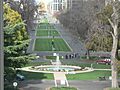
By 1961, work began on the mall's design. It included a wide grassy area in the middle, separating two large streets. Linden trees were planted along the sides. An earlier idea for a round-about at the western end was changed. This was because Interstate 5 was built along the river. It was built below ground so it wouldn't block the view between the Capitol and the Tower Bridge. Both the mall and the interstate were finished by 1965. They still look much the same today.
Famous Buildings on Capitol Mall

Let's take a look at some of the important buildings you'll find along Capitol Mall, starting from the west near the Tower Bridge and moving east towards the Capitol.
1 Capitol Mall: Drexel University Sacramento
At 1 Capitol Mall, you'll find Drexel University Sacramento. This is a California campus of the well-known Drexel University from Philadelphia. It's located close to the Tower Bridge, right between the Sacramento River and where the Mall crosses over Interstate 5.
100 Capitol Mall: Embassy Suites Hotel
The 'Embassy Suites Sacramento - Riverfront Promenade' hotel is at 100 Capitol Mall. It has 242 rooms and is very popular with tourists. This is because it's so close to Old Sacramento State Historic Park and the Riverfront Promenade along the Sacramento River.
300 Capitol Mall: Office Tower

This tall office building stands 18 stories high. It has a lot of space for businesses. It was finished in 1984 and is located at a busy intersection: 3rd Street and Capitol Mall.
301 Capitol Mall: The Towers on Capitol Mall
This spot was once home to the Sacramento Union newspaper. Plans began in 2006 for two very tall buildings here, called The Towers on Capitol Mall I & II. These were planned to be 53 stories high. The project has been on hold since 2007.
.jpg)
400 Capitol Mall: Wells Fargo Center
The 'Wells Fargo Center' at 400 Capitol Mall is currently the tallest building in Sacramento. It is 429 feet (131 meters) high and has 33 stories. In 1994, it won an award for being the Building of the Year. Inside the lobby, there's a museum about the history of Wells Fargo Bank in Sacramento. You can also find a popular restaurant, Il Fornaio, and a major company, Price Waterhouse Coopers, here.
500 Capitol Mall: BMO Tower
500 Capitol Mall, also known as the 'BMO Tower', is a 25-story building in downtown Sacramento. It used to be called the 'Bank of the West Tower'. It has a large parking garage with 800 spaces. The building includes a 5-story lobby, shops on the ground floor, and office spaces. There's also a restaurant or meeting area on the top two floors. The building opened in May 2009.
California State Capitol

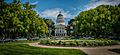
At the very end of Capitol Mall, you'll find the famous California State Capitol building. This is where California's government works. The building and its surrounding gardens are home to the California State Capitol Museum. This beautiful building, with its grand dome, was built between 1860 and 1874. The Capitol and its grounds are a special California Historical Landmark and a National Historic Landmark.
Getting Around: Public Transportation

The Sacramento Regional Transit District (RT) provides public transportation to and along Capitol Mall. RT serves Sacramento city and much of the northern part of Sacramento County.
- Light rail
RT has two light rail stops right on Capitol Mall. The 7th & Capitol Stop is for trains going south. The 8th & Capitol Stop is for trains going north. Both stops serve all three RT light rail lines: the Gold Line, Blue Line, and Green Line.
- Buses
There are also bus stops on Capitol Mall, run by RT. Buses operate daily from 5:00 a.m. to 9:00 p.m. The buses use compressed natural gas to help the environment.
See also
- Old Sacramento State Historic Park — A historic area, just two blocks north of the Mall.
- Crocker Art Museum — An art museum, two blocks south of the Mall.
- Nisei VFW Post 8985 - A historic spot that survived when much of Sacramento's old Japantown was cleared for the Mall.
- Leland Stanford Mansion - The former home of Governor Leland Stanford, one block south of the Mall.
- Sacramento Convention Center Complex - A modern convention center, one block north of the Mall.
- List of tallest buildings in Sacramento
Images for kids
-
Eastbound along the green Capitol Mall
-
Looking west along the Mall towards the Tower Bridge
-
A roundabout at the eastern end of the Mall


