Carbondale, Kansas facts for kids
Quick facts for kids
Carbondale, Kansas
|
|
|---|---|

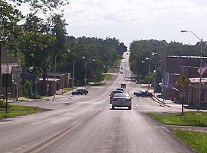
Downtown Carbondale (2005)
|
|

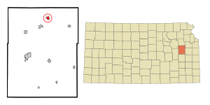
Location within Osage County and Kansas
|
|

|
|
| Country | United States |
| State | Kansas |
| County | Osage |
| Founded | 1869 |
| Incorporated | 1872 |
| Named for | Carbon Coal Company |
| Area | |
| • Total | 0.76 sq mi (1.95 km2) |
| • Land | 0.73 sq mi (1.89 km2) |
| • Water | 0.02 sq mi (0.06 km2) |
| Elevation | 1,125 ft (343 m) |
| Population
(2020)
|
|
| • Total | 1,352 |
| • Density | 1,779/sq mi (693.3/km2) |
| Time zone | UTC-6 (CST) |
| • Summer (DST) | UTC-5 (CDT) |
| ZIP code |
66414
|
| Area code | 785 |
| FIPS code | 20-10600 |
| GNIS ID | 479448 |
Carbondale is a small city in Osage County, Kansas, in the United States. As of the 2020 census, about 1,352 people lived there. It is located south of Topeka along U.S. Route 75.
Contents
History of Carbondale
Carbondale was started in 1869. It grew quickly because of coal mining. The Carbon Coal Company operated here. This is why the city was named Carbondale. Coal is a type of rock used for fuel.
From 1906 to 1908, a group called the Daughters of the American Revolution placed markers. They put 66 markers along the Santa Fe Trail in Kansas. Marker number seventeen is in Carbondale.
Geography and Location
Carbondale is located at 38°49′6″N 95°41′30″W / 38.81833°N 95.69167°W. This is its exact spot on a map. It is the first city you reach south of Topeka, Kansas on U.S. Highway 75.
The city covers a total area of about 0.77 square miles (1.99 square kilometers). Most of this area is land. Only a small part, about 0.02 square miles (0.05 square kilometers), is water.
Population and People
| Historical population | |||
|---|---|---|---|
| Census | Pop. | %± | |
| 1880 | 710 | — | |
| 1890 | 847 | 19.3% | |
| 1900 | 625 | −26.2% | |
| 1910 | 461 | −26.2% | |
| 1920 | 383 | −16.9% | |
| 1930 | 399 | 4.2% | |
| 1940 | 415 | 4.0% | |
| 1950 | 453 | 9.2% | |
| 1960 | 664 | 46.6% | |
| 1970 | 1,041 | 56.8% | |
| 1980 | 1,518 | 45.8% | |
| 1990 | 1,526 | 0.5% | |
| 2000 | 1,478 | −3.1% | |
| 2010 | 1,437 | −2.8% | |
| 2020 | 1,352 | −5.9% | |
| U.S. Decennial Census | |||
Carbondale is part of the larger Topeka, Kansas area. This is known as the Topeka Metropolitan Statistical Area.
Carbondale's Population in 2020
The 2020 United States census counted 1,352 people living in Carbondale. There were 578 households, which are groups of people living together. Most people living in Carbondale were white. About 4% of the population was Hispanic or Latino.
About 25% of the people were under 18 years old. This means many kids and teens live in Carbondale. The average age in the city was about 37.7 years.
Carbondale's Population in 2010
In the census of 2010, there were 1,437 people in Carbondale. There were 590 households. Most people were white. About 3% of the population was Hispanic or Latino.
About 26% of the people were under 18 years old. The average age in the city was 34.3 years. The number of males and females was almost equal.
Education in Carbondale
Carbondale is part of the USD 434 Santa Fe Trail school district. This district also includes the towns of Scranton and Overbrook.
The Carbondale attendance center is a school for students in kindergarten through 8th grade. Older students attend Santa Fe Trail High School. The Santa Fe Trail Chargers are well-known for their sports teams. They won the Kansas State High School boys' basketball championship in 1997. The girls' team won the championship in 1998.
Before the school districts combined, Carbondale had its own high school. The Carbondale Vikings boys' basketball team won a state championship in 1951.
Notable People from Carbondale
- Daniel Forbes, Jr: He was a pioneer pilot in the U.S. Air Force. He flew planes for taking pictures.
- Barnum Brown: He was a famous paleontologist from the American Museum of Natural History. He studied dinosaurs and ancient life.
See also
 In Spanish: Carbondale (Kansas) para niños

