
Cardenas Butte facts for kids
Quick facts for kids Cardenas Butte |
|
|---|---|
.jpg)
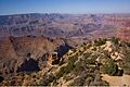
Cardenas Butte-(left, (Esplanade Sandstone)), lower butte (Manakacha Formation-(shelf-center-left))
|
|
| Highest point | |
| Elevation | 6,281 ft (1,914 m) |
| Prominence | 481 ft (147 m) |
| Isolation | 0.80 mi (1.29 km) |
| Parent peak | Escalante Butte |
| Geography | |

Cardenas.Butte
Location in Arizona

Cardenas.Butte
Location in the United States
|
|
| Location | Grand Canyon National Park Coconino County, Arizona, US |
| Parent range | Coconino Plateau Colorado Plateau |
| Topo map | USGS Desert View |
| Geology | |
| Age of rock | Pennsylvanian down to Cambrian |
| Mountain type | sedimentary rock: sandstone, siltstone, mudstone, sandstone, shale |
| Type of rock | Supai Group-(eroded ridgeline), Redwall Limestone, Muav Limestone, Bright Angel Shale |
Cardenas Butte is a mountain peak in the eastern Grand Canyon, in Coconino County, Arizona, USA. It stands 6,281 feet (about 1,914 meters) tall.
This butte is named after García López de Cárdenas. He was the first European explorer to see the amazing Grand Canyon. Cardenas Butte is found on a reddish-orange ridge. It is next to a taller peak called Escalante Butte. Both buttes are about 1.5 miles northwest of Navajo Point. This area is in the far eastern part of the Grand Canyon's South Rim.
Water flows from Cardenas Butte in different directions. Tanner Canyon drains the east side, leading north to the Colorado River. Cardenas Creek drains the northwest side. An unnamed stream drains the north. The Tanner Trail is a hiking path that goes past these buttes. It follows the upper ridges of Escalante and Cardenas Butte. The trail then drops down through different rock layers. Cardenas Butte is about 300 feet (91 meters) lower than Escalante Butte.
Geology of Cardenas and Escalante Buttes
.jpg)
Cardenas Butte and Escalante Butte are part of the same long ridge. This ridge is made mostly of rock layers from the Supai Group. Escalante Butte is to the west, separated by a low point in the ridge. This low point allows water to drain into Upper Tanner Canyon.
Escalante Butte's top part is a small, worn-down cliff. It is made of Coconino Sandstone sitting on top of Hermit Formation rock. These layers are on the older, eroded ridges of the Supai Group.
Cardenas Butte is about 300 feet lower than Escalante Butte. It is located about 0.8 miles (1.3 km) to the east. Its small peak is a remaining cliff section of the Supai Group. This cliff and flat area are made of a rock unit called the Esplanade Sandstone. There might also be some broken rock pieces from the Hermit Formation on its surface.
Images for kids
-
Cardenas Butte (left) and Escalante Butte (right).
-
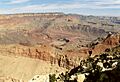
The Grand Canyon showing different rock layers.
