Celestial coordinate system facts for kids
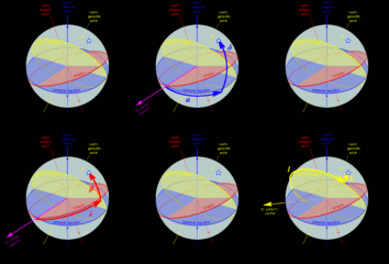
A celestial coordinate system is like a special map that helps scientists called astronomers find the exact spot of objects in the sky. These objects can be anything from bright stars and distant planets to orbiting satellites. Think of it as giving everything in space its own address!
All these sky maps use a spherical shape, like a giant ball. They have a main flat surface, called the fundamental plane. This plane splits the sky into two equal halves, just like the equator divides Earth. The "poles" are straight up and down from this plane. There's also a starting line, called the "primary direction," which is like the Prime Meridian on Earth.
Contents
Different Sky Maps
Scientists use several common sky maps to locate things in space:
Horizontal Sky Map
The horizontal system is based on where you are standing on Earth. It helps you find and follow objects in the sky from your exact spot. This system uses your own horizon as its main flat surface.
Equatorial Sky Map
The equatorial system is based on Earth's equator. Imagine stretching Earth's equator out into space forever! This map describes the sky as if you were looking at it from our Solar System. Most modern star maps use this system.
Ecliptic Sky Map
The ecliptic system uses the flat path of Earth's orbit around the Sun as its main plane. This path is called the ecliptic plane.
There are two versions:
- Earth-centered ecliptic: This map is centered on Earth. It was very important in ancient times. It is still useful for figuring out where the Sun, Moon, and planets appear to be from Earth.
- Sun-centered ecliptic: This map is centered near the Sun. It helps scientists track how planets and other objects move around the Sun. It is great for understanding their paths.
Galactic Sky Map
The galactic system uses the flat shape of our own galaxy, the Milky Way, as its main plane. Even though it's about the galaxy, our Solar System is still the center of this map. The starting point is set towards the center of our galaxy. "Galactic latitude" tells you how high or low an object is from the galaxy's flat plane. "Galactic longitude" tells you its direction around the galaxy's center.
Supergalactic Sky Map
The supergalactic system uses a special plane that has many local galaxies in it, as seen from Earth. It helps map out very large groups of galaxies.
Software for Sky Maps
Scientists use special computer programs to do the calculations for these sky maps:
- NOVAS: Naval Observatory Vector Astronomy Software. [1]
- IAU Standards of Fundamental Astronomy. [2]
| Sky Map Name | Center Point | Main Flat Surface (0° latitude) |
Poles | Coordinates | Starting Direction (0° longitude) |
|
|---|---|---|---|---|---|---|
| Up/Down (Latitude) | Around (Longitude) | |||||
| Horizontal | You (the Observer) | Your Horizon | Zenith (straight up), nadir (straight down) | Altitude (a) or elevation | Azimuth (A) | North or south point of horizon |
| Equatorial | Center of Earth (geocentric) or Sun (heliocentric) | Celestial equator | Celestial poles | Declination (δ) | Right ascension (α) or hour angle (h) | Vernal equinox |
| Ecliptic | Center of Earth (geocentric) or Sun (heliocentric) | Ecliptic (Earth's orbit plane) | Ecliptic poles | Ecliptic latitude (β) | Ecliptic longitude (λ) | Vernal equinox |
| Galactic | Center of the Sun | Galactic plane (Milky Way's flat part) | Galactic poles | Galactic latitude (b) | Galactic longitude (l) | Galactic center |
| Supergalactic | (Not specified) | Supergalactic plane | Supergalactic poles | Supergalactic latitude (SGB) | Supergalactic longitude (SGL) | Where supergalactic plane meets galactic plane |
Images for kids
See also
 In Spanish: Coordenadas celestes para niños
 | Valerie Thomas |
 | Frederick McKinley Jones |
 | George Edward Alcorn Jr. |
 | Thomas Mensah |


