
Chaistla Butte facts for kids
Quick facts for kids Chaistla Butte |
|
|---|---|
.jpg)
West aspect
|
|
| Highest point | |
| Elevation | 6,098 ft (1,859 m) |
| Prominence | 548 ft (167 m) |
| Isolation | 2.36 mi (3.80 km) |
| Parent peak | Segeke Butte (6,721 ft) |
| Geography | |

Chaistla Butte
Location in Arizona

Chaistla Butte
Location in the United States
|
|
| Location | Navajo Reservation Navajo County, Arizona, U.S. |
| Parent range | Colorado Plateau |
| Topo map | USGS Agathla Peak |
| Geology | |
| Age of rock | Oligocene |
| Type of rock | Volcanic breccia |
| Climbing | |
| Easiest route | class 5.x climbing |
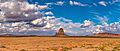
Chaistla Butte is a tall rock formation in northeast Arizona. It stands 6,098 feet (1,859 meters) high. You can find it in Navajo County, south of Monument Valley. This butte is about 4.5 miles (7.2 km) northeast of Kayenta. It is located on Navajo Nation land. You can easily see it from Highway 163.
Chaistla Butte is part of the Navajo Volcanic Field. This area has many volcanic rocks that formed about 30 million years ago. These rocks are called igneous rocks. They formed when hot, melted rock cooled down. The butte itself is an eroded volcanic plug. This means it's the hard core of an ancient volcano. It rises 400 feet (122 meters) above the Little Capitan Valley. Its base is about 1,000 by 700 feet. Nearby rock formations include Agathla Peak and Owl Rock. These are about three miles (4.8 km) to the north. Water from Chaistla Butte flows into the Laguña Creek area.
The name Chaistla comes from the Navajo language. It means "beaver pocket" or "beaver corner." The U.S. Board on Geographic Names officially adopted this name in 1915. Some Navajo teachings say its name means "to support the sky's underside." They believe if this butte were to fall, the world would end. It is also known as Turkey Butte.
Contents
Exploring Chaistla Butte's Geology
Chaistla Butte is a great example of a volcanic plug. Imagine a volcano that was active millions of years ago. When it stopped erupting, magma (melted rock) cooled inside its vent. This hard rock core is what we call a volcanic plug. Over time, wind and water wore away the softer outer layers of the volcano. This left behind the tough inner plug.
What Are Diatremes?
Chaistla Butte is also called a diatreme. A diatreme is a type of volcanic pipe. It forms when gas explodes through the Earth's crust. This explosion creates a wide, cone-shaped hole. This hole then fills with broken rock pieces. These pieces are called volcanic breccia. The rocks here formed during the Oligocene epoch. This was a time period about 30 million years ago.
The rocks in the Navajo Volcanic Field are special. They include a type of rock called minette. Minette is an unusual igneous rock. It is rich in certain minerals. Scientists study these rocks to learn about the Earth's deep past. They help us understand how volcanoes form.
Weather Around Chaistla Butte
The best times to visit Chaistla Butte are spring and fall. The weather is usually pleasant then.
Understanding the Climate
Chaistla Butte is in a semi-arid climate zone. This means it gets very little rain. It has cold winters and hot summers.
- Summers: Summers are hot. Temperatures often go above 90°F (32°C). They rarely get hotter than 100°F (38°C). Nights are cool, and temperatures drop quickly after sunset.
- Winters: Winters are cold. But daytime temperatures are usually above freezing. It rarely gets below 0°F (-18°C), but it can happen.
- Rainfall: This desert area gets less than 10 inches (254 mm) of rain each year. Snowfall in winter is usually light.
Gallery
-

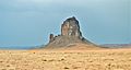
Chaistla Butte, also known as Turkey Butte (the turkey's head is to the left)
-
-
-

-
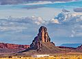
Agathla Peak (left) and Chaistla Butte (right) seen from the southwest along Highway 163
-
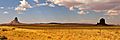
Northwest view


