Changtang facts for kids
Quick facts for kids Changtang |
|||||||||
|---|---|---|---|---|---|---|---|---|---|
| Chinese name | |||||||||
| Chinese | 羌塘 | ||||||||
|
|||||||||
| Alternative Chinese name | |||||||||
| Chinese | 藏北高原 | ||||||||
| Literal meaning | North Tibet plateau | ||||||||
|
|||||||||
| Tibetan name | |||||||||
| Tibetan | བྱང་ཐང་། | ||||||||
|
|||||||||
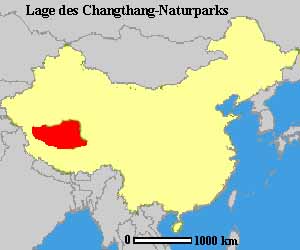
The Changtang (also called Changthang or Qangtang) is a huge area on the high Tibetan Plateau. It is found in western and northern Tibet, reaching into southern Xinjiang and southeastern Ladakh, India. This region has wide open lands and very large lakes.
From eastern Ladakh, the Changtang stretches about 1,600 kilometers (990 miles) east. It goes all the way into Tibet, reaching modern Qinghai. The Changtang is home to the Changpa, who are nomadic Tibetan people. The two biggest towns in the Tibetan Changtang are Rutog Town and Domar Township.
Contents
Climate and Weather
The summers in Changtang are warm but short. Thunderstorms can happen at any time of the year, often bringing hail. Winters are very cold, like the Arctic. This is because the area is very high up, even though it's not near the North Pole.
History of the Region
Long ago, the Changtang was ruled by a group of people called the Zhangzhung. Later, their culture joined with the Tibetan culture.
People of Changtang
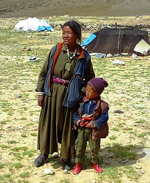
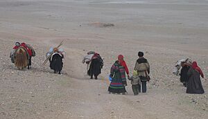
The people living in Changtang are nomadic pastoralists. This means they move around with their animals to find food for them. They are known as 'Changpa', which means 'northerners'. They are also called 'Drokpa', meaning 'nomads' in Tibetan.
In 1989, about half a million nomads lived in Changtang. Unlike many other nomadic groups, the Changpa are not bothered by farmers. This is because most of their land is too harsh for farming.

The economy of this area depends on the animals the Changpa raise. The most important resource is the plants their animals eat. The Changpa move their animals over the year. This helps to protect the grazing lands. The grasses are dead for most of the year and are not good food then.
The Changpa do not move from one climate to another. This means they often travel shorter distances, usually about 10 to 40 miles. They follow the same routes every year. They often stay in the same camps, which might have stone walls for animals and tents. Richer nomads might even have buildings for storage and living in part of the year.
The Changpa have found many ways to deal with times of plenty and times of little. In summer, when animals make a lot of milk, they turn it into things that last longer. These include butter and cheese. Animals are killed early in winter. This is after they have gotten fat in summer. The cold weather also helps to store the meat.
Trade is very important for the Changpa. They cannot make everything they need. They trade salt, meat, live animals, wool, and raw cashmere. In return, they get basic things like grain, cooking pots, and metal tools. They also trade for more modern goods.
Tibetan Changtang Area
Most of the Tibetan Changtang is now protected. It is part of nature reserves. The Chang Tang Nature Reserve is the second-largest nature reserve in the world. There are also four new smaller reserves next to it. Together, these protected areas cover 496,000 square kilometers (192,000 sq mi). This area is almost as big as Spain.
Since these reserves were created, the number of endangered animals has grown. This is good news. These protected areas are in parts of the Tibet Autonomous Region, Xinjiang, and Qinghai in China.
The Tibetan Changtang is in the Nagqu prefecture. Its average height is 5,000 meters (16,000 ft) above sea level. The Nagqu Horse Festival is the most important festival held here.
Ladakhi Changtang Area
Only a small part of Changtang goes into Ladakh, in India. But it is on an old, important path for travelers. This path goes from Ladakh to Lhasa. Now, this part of Changtang has changed a lot because it is in India.
Like the rest of Ladakh, Changtang has been changing since the late 1900s. Ladakh is one of the places in India that gets a lot of international tourists. Old ways of life and culture are changing fast. This is due to modern lifestyles and wanting to buy more things. This brings both worries and hopes for the people there.
Another big change is the Tibetan settlement. The Tibetan government-in-exile asked for this settlement. It started in 1963 with almost 3,000 people. Today, it has more than 7,000 settlers. For managing purposes, the Ladakh settlement is split into two parts: Sonamling and Changtang.
The Changthang Wildlife Sanctuary is home to many rare plants and animals. They are well cared for in this special place. The sanctuary is high up in the Leh district of Ladakh.
The Changtang Wildlife Sanctuary has three large and famous lakes around it. These are the Tsomoriri, the Tsokar Lake, and the Pangong Tso.
Tsomoriri is a huge mountain lake in southeastern Ladakh. Karzok village is on its northwest bank. It is 4,560 meters (14,960 ft) above sea level. People say it is the highest village in the world where people live all year. The Tsokar Lake is in the Rupshu valley. It is famous as the Salt Lake of Ladakh.
The Changtang Wildlife Sanctuary has natural grasslands. More than 200 types of wild plants grow in the higher pastures. Most of these plants can be eaten by animals.
Changtang Hamlets
Changtang hamlets were created when many Tibetan nomads moved to Ladakh. Most of them came from western Tibet. They settled in nearby places in Ladakh. More than 3,500 Tibetan refugees live in the Changtang region. They mostly depend on raising animals. Farming is their second job.
These nomads were organized into Tibetan refugee settlements in 1977. This was done by the Central Tibetan Administration, Dharamsala. The Government of India and the state government helped. There are nine different settlements: Nyoma, Kagshung, Goyul, Hanley, Sumdho, Samedh, Karnag, Chushul, and Churmur.
These settlements are spread out across the high plateau. Their average height is 4,700 meters (15,400 ft). The temperature changes a lot. In winter, it can be from -5 to -35 degrees Celsius (23 to -31 °F). In summer, it can reach up to 30 degrees Celsius (86 °F).
Large parts of Changtang are very dry. Not many plants grow in the whole region. Farmlands and pastures are only found in small areas along riverbanks. The average snowfall is less than 10 millimeters (0.39 in). It usually snows in December, January, and February.
Sometimes, there is unusual and heavy snowfall. This happened in March 2012. It can be very bad for the nomads' animals. Goats and sheep sometimes cannot reach grass for up to 15 days. This is the hardest time of the year for the nomads.
Education in Ladakh is managed by the SOS Tibetan Children Village. This group helps Tibetan children get an education. They have schools from crèche (preschool) up to tenth grade. Most students go to day school. But there are also places for very poor students and those from nomad camps to live at the school. Almost all children get to go to school. The children's education level is quite good.
The settlements have one modern hospital. They also have one Tibetan medical and Astro clinic. There is also a bird sanctuary.
Changthang Cold Desert Wildlife Sanctuary
The Changthang Wildlife Sanctuary is a special place for animals. It is also called the Changthang Cold Desert Wildlife Sanctuary. It is a high-altitude wildlife sanctuary. It is located in the Ladakh part of the Changtang plateau. This sanctuary is important because it is one of the few places in India with kiangs. These are Tibetan wild asses. It also has the rare black-necked crane.
The Changtang Cold Desert Wildlife Sanctuary is part of the Hindu Kush Himalaya mountains. This area is naturally beautiful.
The sanctuary's height changes from 14,000 to 19,000 feet (4,300 to 5,800 m). The land has deep valleys and wide flat areas. There are about 11 lakes and 10 marshy areas in the sanctuary. The grand Indus River flows through it, splitting it into two parts.
The cold desert here has few plants. But the tough conditions have led to plants with special features. Seven rare and endangered plants were found here by C.P. Kala. Some people believe these plants have medicinal properties. Three of these plants are listed as vulnerable. One is listed as endangered on the IUCN Red List. These include Arnebia euchroma, Geranium sibiricum, Lancea tibetica, Lloydia serotina, and Ephedra gerardiana.
Other Interesting Places
The lake Tso Moriri in Ladakh is one of the highest lakes of its size in the world. Tso Moriri covers an area of 120 square kilometers (46 sq mi). It is up to 40 meters (130 ft) deep. It is located 4,525 meters (14,846 ft) above sea level. In November 2002, the lake was named a Ramsar site. This means it is an important wetland.
Pangong Tso stretches across Ladakh and Tibet's Rutog County. It is about 4,240 meters (13,910 ft) above sea level. It covers an area of 134 square kilometers (52 sq mi) from India to China. The water in the Ladakh part is salty. In Tibet, it is less salty. The water freezes during winter.
The Pashmina goat is famous for its very fine Cashmere wool. The word "Pashmina" in Persian means 'made from wool'. In Kashmiri, it means 'soft gold'. This type of goat lives on the Changthang plateau. That is how it got its name. Pashmina shawls are spun by hand in Kashmir and Nepal.
See also
 In Spanish: Changtang para niños
- Changthangi, a type of goat
- Hoh Xil, a plateau in Tibet
- Hemis National Park
- Karakorum Wildlife Sanctuary
- Tourism in Ladakh
 | Anna J. Cooper |
 | Mary McLeod Bethune |
 | Lillie Mae Bradford |


