Chno Dearg facts for kids
Quick facts for kids Chno Dearg |
|
|---|---|
| A' Chnò Dhearg | |

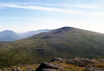
Chno Dearg seen from Stob Coire Sgriodain, two km to the west.
|
|
| Highest point | |
| Elevation | 1,046 m (3,432 ft) |
| Prominence | 649 m (2,129 ft) |
| Listing | Munro, Marilyn |
| Naming | |
| English translation | Red Nut or Red Hill |
| Language of name | Gaelic |
| Pronunciation | English approximation: Ə-khraw-YERR-ek |
| Geography | |
| Location | Lochaber, Highland, Scotland |
| Parent range | Grampians |
| OS grid | NN377740 |
| Topo map | OS Landranger 41, OS Explorer 393 |
Chno Dearg is a Scottish mountain located about 25 kilometers (15 miles) east of Fort William, Highland. It sits in the Lochaber area of the Highland region. Its name comes from Gaelic, meaning "Red Hill." This name likely refers to the many heather plants that grow on its slopes.
About Chno Dearg
Chno Dearg stands tall at 1046 meters (3432 feet). This height makes it a Munro, which is a Scottish mountain over 3000 feet (914.4 meters). It is also a Marilyn, a hill with a certain prominence. Chno Dearg is found east of Loch Treig, between the loch and Strath Ossian.
While it's a significant mountain, some describe Chno Dearg as a "rounded" hill. This means its slopes are not very steep or rocky. Climbing it can feel a bit long because of its gentle, curving sides. A nearby mountain, Stob Coire Sgriodain, is often climbed with Chno Dearg. Stob Coire Sgriodain is a bit lower but is considered more exciting to climb.
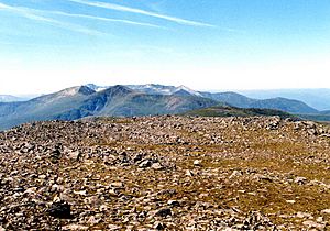
Chno Dearg offers amazing views from its top. You can see the Creag Meagaidh group of hills to the northeast. The mountain is also popular for ski mountaineering. Its wide northern slopes are perfect for a long ski run. You can ski down about 750 meters (2460 feet) over five kilometers (three miles).
Mountain Geography
Chno Dearg's wide northern side slopes gently down to Glen Spean and Loch Laggan. The lower parts of these slopes are covered by a large forest. This area can be a bit wet with many small streams. You'll also find a smaller peak here called Meall Chaorach, which is 815 meters (2674 feet) high. It is about 1.5 kilometers (1 mile) from the main summit.
On the western side of the mountain is a shallow valley called Coire an Lochain. This valley has gentle slopes and holds a small lake, Lochan Coire an Lochain. The main ridge of Chno Dearg goes southwest from the summit. It reaches a dip, or "col," which is 923 meters (3028 feet) high.
From this dip, the ridge splits into two paths. One path curves around Coire an Lochain and heads north. This path connects Chno Dearg to the nearby Munro, Stob Coire Sgriodain. The other path continues south to a peak called Meall Garbh. Meall Garbh is 976 meters (3202 feet) high and has steep cliffs on its eastern side.
The southern part of Chno Dearg has a steep valley called Coire nan Cnamh. This valley drops sharply into the glen of the Allt Feith Thuill. This stream eventually flows into the River Ossian. All the water from Chno Dearg flows north into the River Spean. The River Spean then flows west towards the coast of Scotland.
How to Climb Chno Dearg
Most people start their climb of Chno Dearg from the small village of Fersit. It is common to climb both Chno Dearg and the nearby Munro, Stob Coire Sgriodain, on the same trip. The route from Fersit allows you to make a loop around Coire an Lochain. You can also take a short detour to visit Meall Garbh.
Another way to climb these mountains is by using the West Highland Line railway. You can start your hike from Corrour railway station. From there, you might first climb Beinn na Lap. Then, you can continue north over Chno Dearg and Stob Coire Sgriodain. You can finish your hike at Tulloch railway station to catch an evening train.
 | Lonnie Johnson |
 | Granville Woods |
 | Lewis Howard Latimer |
 | James West |


