Clay, New York facts for kids
Quick facts for kids
Clay, New York
|
|
|---|---|

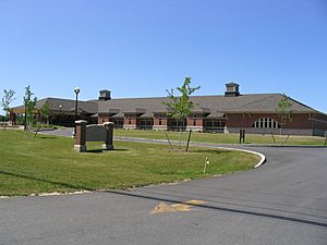
Clay town hall
|
|

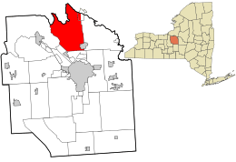
Location in Onondaga County and the state of New York.
|
|
| Country | United States |
| State | New York |
| County | Onondaga |
| Government | |
| • Type | Town Council |
| Area | |
| • Total | 48.86 sq mi (126.54 km2) |
| • Land | 47.96 sq mi (124.21 km2) |
| • Water | 0.90 sq mi (2.33 km2) |
| Elevation | 377 ft (115 m) |
| Population
(2020)
|
|
| • Total | 60,527 |
| • Density | 1,238.78/sq mi (478.323/km2) |
| Time zone | UTC-5 (Eastern (EST)) |
| • Summer (DST) | UTC-4 (EDT) |
| ZIP code |
13041, 13090, 13088
|
| Area code(s) | 315 |
| FIPS code | 36-16067 |
| GNIS feature ID | 0978835 |
Clay is a busy town located in Onondaga County, New York. It's part of the United States. In 2020, about 60,527 people lived here. This makes Clay the largest suburb of Syracuse. The town was named after a famous American leader, Henry Clay.
Clay is found just north of Syracuse. It's the biggest town in Onondaga County. Part of the village of North Syracuse is also inside Clay. The town has many shops and stores, especially along New York State Route 31 (NY-31). This area used to have the Great Northern Mall.
Contents
A Look Back: The History of Clay
Who Lived Here First?
Before Europeans settled in this area, the land was home to the Onondaga Nation. They are part of the Iroquois Confederacy, a group of Native American nations. Some of their descendants still live in the area today.
How Clay Became a Town
The area of Clay was once part of a special land division called the Central New York Military Tract. Around 1791, new settlers started to arrive. The town was first known as West Cicero. In 1827, the Town of Clay was officially formed. It was created from a larger area called the Town of Cicero.
Big News for Clay's Future
In October 2022, a major technology company called Micron Technology announced big plans for Clay. They promised to invest $100 billion to build a huge complex for making computer chips. This project will be located in the White Pine Commerce Park in Clay. It's expected to bring many new jobs and opportunities to the town.
Exploring Clay: Geography and Landmarks
Where is Clay Located?
Clay covers about 48.8 square miles (126.5 square kilometers). Most of this area is land, with a small part being water.
The northern edge of Clay borders Oswego County. This border is marked by the Oneida River. The Seneca River forms the western border of the town. Both these rivers meet to form the Oswego River near a place called Three Rivers. The famous Erie Canal, which has been updated, also follows these rivers around Clay's border.
Major Roads in Clay
New York State Route 31 is a main road that runs east to west through the town. Another important road, New York State Route 481, crosses NY-31 west of a community called Euclid.
Neighborhoods and Places to Visit
Clay has many different communities and areas. Here are some of them:
- Bayberry — A community with many homes.
- Belgium — A small village on NY-31, near the western edge of town.
- Cherry Estates — A small village near the eastern edge of town.
- Clay — This is the main village of Clay, located on NY-31.
- Country Meadow — A large and growing neighborhood off Caughdenoy Road.
- Elmcrest — A small village in the southwest part of Clay.
- Euclid — A small village in the northern part of town, on NY-31.
- Fairway East — A large area with many homes, connecting Morgan Road and Soule Road.
- Gatewood — A neighborhood in the eastern part of town, off Maple Road.
- Great Northern Mall — A large shopping mall where routes NY-31 and NY-481 meet. It opened in 1988.
- Kimbrook — Another community with homes.
- Lawton Valley Hunt — A very large housing area between Caughdenoy Road, NY-31, and Lawton Road.
- Lynelle Meadows — A community with homes.
- Moyers Corners — A small village on NY-31, east of Belgium.
- North Syracuse — Most of this village is within the Town of Clay.
- Pinegate North & South — A community located near Soule Road Middle and Elementary Schools.
- Rodger Corner — A small village south of Clay village.
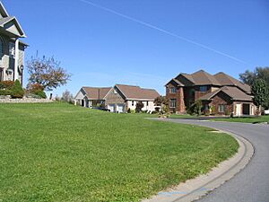
- The Farmstead — A newer, upscale neighborhood off Maple Road.
- Three Rivers — A small village at the western town line. It's where the Oneida, Oswego, and Seneca Rivers meet.
- Willow Stream — A community with homes.
- Woodard — A small village in the southwest part of Clay.
- Youngs — A small village north of Clay village.
People of Clay: Demographics
| Historical population | |||
|---|---|---|---|
| Census | Pop. | %± | |
| 1830 | 2,095 | — | |
| 1840 | 2,852 | 36.1% | |
| 1850 | 3,402 | 19.3% | |
| 1860 | 3,583 | 5.3% | |
| 1870 | 3,156 | −11.9% | |
| 1880 | 2,910 | −7.8% | |
| 1890 | 2,630 | −9.6% | |
| 1900 | 2,578 | −2.0% | |
| 1910 | 2,431 | −5.7% | |
| 1920 | 2,488 | 2.3% | |
| 1930 | 3,560 | 43.1% | |
| 1940 | 4,050 | 13.8% | |
| 1950 | 7,001 | 72.9% | |
| 1960 | 17,760 | 153.7% | |
| 1970 | 36,274 | 104.2% | |
| 1980 | 52,838 | 45.7% | |
| 1990 | 59,749 | 13.1% | |
| 2000 | 58,805 | −1.6% | |
| 2010 | 58,206 | −1.0% | |
| 2020 | 60,527 | 4.0% | |
| U.S. Decennial Census | |||
In 2000, there were 58,805 people living in Clay. There were 22,294 households, which are groups of people living together. About 15,940 of these were families. The population density was about 1,225 people per square mile.
Many households (38%) had children under 18 living with them. Most households (56.9%) were married couples. About 22.3% of all households were people living alone. The average household had 2.63 people.
The population was spread out by age. About 27.7% were under 18 years old. The median age was 35 years. This means half the people were younger than 35, and half were older.
The average income for a household in Clay was $90,412. For families, the average income was $97,493. About 5.7% of all people in Clay lived below the poverty line. This included 7.5% of those under 18.
Keeping Clay Safe and Running Smoothly
Fire Departments
Several fire departments help keep Clay safe. The main ones are Moyers Corners Fire Department and Clay Fire Department. Parts of Clay are also covered by North Syracuse, Caughdenoy, and Brewerton Fire Departments.
Police Services
Clay used to have its own police department. However, in 2008, the Clay Police Department joined with the Onondaga County Sheriff's Office. Now, the Sheriff's Office helps keep the town safe.
Famous People from Clay
Some well-known individuals have connections to Clay:
- Patrick Corbin — A professional baseball pitcher who plays for the Washington Nationals.
- Matilda Maranda Crawford — A newspaper writer.
- Richard Gere — A famous actor who grew up in Clay and graduated from North Syracuse High School in 1967.
- James W. Ostrander — A politician.
- Jack Smith — A lawyer.
See also
 In Spanish: Clay (Nueva York) para niños
 | Madam C. J. Walker |
 | Janet Emerson Bashen |
 | Annie Turnbo Malone |
 | Maggie L. Walker |


