
Cotter, Arkansas facts for kids
Quick facts for kids
Cotter, Arkansas
|
|
|---|---|

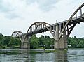
Cotter Bridge over the White River
|
|
| Motto(s):
"Trout capital U.S.A."
|
|

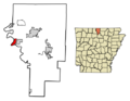
Location of Cotter in Baxter County, Arkansas.
|
|
| Country | United States |
| State | Arkansas |
| County | Baxter |
| Incorporated | November 23, 1905 |
| Government | |
| • Type | Mayor–council |
| Area | |
| • Total | 2.45 sq mi (6.34 km2) |
| • Land | 2.45 sq mi (6.34 km2) |
| • Water | 0.00 sq mi (0.00 km2) |
| Elevation | 640 ft (200 m) |
| Population
(2020)
|
|
| • Total | 886 |
| • Density | 362.08/sq mi (139.78/km2) |
| Time zone | UTC-6 (Central (CST)) |
| • Summer (DST) | UTC-5 (CDT) |
| ZIP code |
72626
|
| Area code(s) | 870 |
| FIPS code | 05-15490 |
| GNIS feature ID | 2404136 |
Cotter is a city located in Baxter County, Arkansas, in the United States. It's known for its beautiful setting on the White River. In 2020, about 886 people lived there.
Contents
History of Cotter

Long before settlers arrived, the Cotter area was home to Native American groups called Bluff Dwellers. Later, around 1,000 Cherokees crossed the White River near Cotter during the Trail of Tears. This was a difficult journey when many Native Americans were forced to move west.
Early Explorers and Settlers
In 1819, an explorer named Henry Schoolcraft visited the Ozarks. He spent a night in the Cotter area and was amazed by the White River. He described it as one of the most "beautiful and enchanting streams" he had ever seen. The river was so clear and bright that French traders called it "La Rivière Blanche," meaning "White River."
In 1868, Jonathan Cunningham started a farm on 300 acres of land by the White River. Later, in 1883, he sold this land to L.P. Kemp. At that time, there was a ferry nearby called Lake's Ferry. It was the only way to cross the river. Families would come from other towns to picnic, fish, and enjoy a natural spring.
In 1892, Herbert Hoover, who later became a U.S. president, helped a Geologist named John C. Branner explore the northern Ozarks. By the early 1900s, many mining companies were active in the area. Cotter became an important place where minerals could be shipped by steamboat to larger cities.
A post office opened in Cotter in 1902. In 1903, L.P. Kemp sold his land to the Red Bud Realty Company. The town grew quickly. A school opened in 1904. On November 23, 1905, Cotter officially became a city.
The White River Railroad Line
The Missouri-Pacific Railroad saw a chance to grow its business in the area. They planned to build the White River Line, which would go through Cotter. In 1905, the railroad bought land in Cotter and sold many lots, mostly to its employees. The city was named after William Cotter, an official for the Missouri Pacific Railway System.
Building the town and railroad needed many materials. These were brought in by steamboats on the White River. Once the railroad was finished, steamboats were used less and less. In 1906, the first passenger train arrived in Cotter, and the town became a popular place for tourists.
After the railroad was built, many African American workers who helped construct it moved away from Cotter. Over time, the number of African American residents in the town became very small.
The Cotter Bridge
Crossing the White River was often difficult for drivers. The closest bridge was more than 100 miles away. People had to use an inconvenient ferry system. Locals really wanted a bridge, but they didn't want to pay tolls.
At that time, Arkansas didn't have a main highway department. Building a bridge was hard because different "road districts" had to agree. Funding for a bridge without tolls became available when Arkansas Highway 12 became U.S. Route 62 in 1930. The famous Cotter Bridge was then built. It has a special "rainbow arch" design.
Geography of Cotter
Cotter is located entirely on land. It covers an area of about 2.5 square miles (6.34 square kilometers).
Population Information
| Historical population | |||
|---|---|---|---|
| Census | Pop. | %± | |
| 1910 | 894 | — | |
| 1920 | 884 | −1.1% | |
| 1930 | 1,064 | 20.4% | |
| 1940 | 903 | −15.1% | |
| 1950 | 1,089 | 20.6% | |
| 1960 | 683 | −37.3% | |
| 1970 | 858 | 25.6% | |
| 1980 | 920 | 7.2% | |
| 1990 | 867 | −5.8% | |
| 2000 | 921 | 6.2% | |
| 2010 | 970 | 5.3% | |
| 2020 | 886 | −8.7% | |
| U.S. Decennial Census | |||
Cotter's Population in 2020
In 2020, there were 886 people living in Cotter. There were 419 households and 271 families in the city.
| Race | Number | Percentage |
|---|---|---|
| White (non-Hispanic) | 784 | 88.49% |
| Black or African American (non-Hispanic) | 1 | 0.11% |
| Native American | 7 | 0.79% |
| Asian | 4 | 0.45% |
| Other/Mixed | 68 | 7.67% |
| Hispanic or Latino | 22 | 2.48% |
Cotter's Population in 2010
In 2010, Cotter had 1,078 people. The population density was about 374 people per square mile. Most residents (97.07%) were White. About 1.52% of the population was Hispanic or Latino.
The average household had about 2.08 people. The average family had about 2.67 people.
The population was spread out by age. About 19.7% were under 18 years old. About 20.2% were 65 years or older. The average age was 43 years.
The median income for a household was $22,857. For a family, it was $34,375. About 16.8% of the population lived below the poverty line. This included 18.3% of those under 18.
Education in Cotter
Formal schooling in Cotter began on January 4, 1904. Miss Cora Patterson taught 40 students under a tent! Over the years, Cotter schools joined with nearby districts.
Today, students in Cotter attend schools run by the Cotter School District. These include Cotter High School for grades 7 through 12. Younger students, from kindergarten to grade 6, go to Amanda Gist Elementary School.
Media and News
Cotter and Baxter County are part of the Springfield, Missouri TV market.
Cotter has had five different newspapers over the years. The Cotter Courier (1903-1918) and The Cotter Record (1911-1937) lasted the longest. Today, news about Cotter is covered by The Baxter Bulletin.
Transportation and Infrastructure
Major Highways

 US 62/US 412
 U.S. Route 62 Business
 Arkansas Highway 345
Railroads
Cotter has a local railroad called the Missouri and Northern Arkansas Railroad (MNA). This railroad leases tracks from Newport to Kansas City, Missouri. These tracks are owned by the Union Pacific. Trains often carry empty coal cars. There is also a small railyard in Cotter where train crews can change shifts.
Airports
Cotter is close to two commercial airports: Ozark Regional Airport and Flippin Municipal Airport. There is also a small rural airfield called Valley Airport. It is used by small planes owned by local residents.
Images for kids
-
Cotter Bridge over the White River
-
Location of Cotter in Baxter County, Arkansas.
See also
 In Spanish: Cotter (Arkansas) para niños
