Cottonwood Pass facts for kids
Quick facts for kids Cottonwood Pass |
|
|---|---|

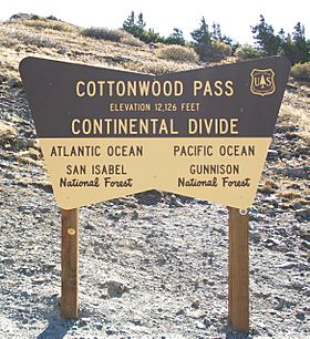
Sign marking the Continental Divide atop Cottonwood Pass.
|
|
| Elevation | 12,119 ft (3,694 m) |
| Traversed by | Chaffee County Road 306 Gunnison County Road 209 |
| Location | Chaffee–Gunnison counties, Colorado, U.S. |
| Range | Saguache Range |
| Coordinates | 38°49′40.31″N 106°24′33.37″W / 38.8278639°N 106.4092694°W |
| Topo map | Tincup |
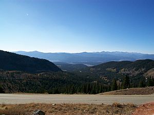
Cottonwood Pass is a very high mountain pass in Colorado, in the western United States. It's part of the Rocky Mountains. The pass sits on the border between Gunnison and Chaffee counties. It is located in the Sawatch Range of mountains.
This pass is super high, reaching 12,119 feet (3,694 meters) above sea level! The area around the pass is mostly covered in forest. To the east, you'll find the San Isabel National Forest. To the west, there's the Gunnison National Forest.
The Continental Divide crosses right over Cottonwood Pass. This is a special line where water on one side flows to the Pacific Ocean, and water on the other side flows to the Atlantic Ocean. Cottonwood Pass is the highest paved road that crosses the Continental Divide in the entire U.S. It's also one of the highest paved roads in Colorado.
Driving Cottonwood Pass
The road over Cottonwood Pass is usually closed for part of the year. Heavy snowfall makes it impossible to drive, typically from October until May. When it's open, you can drive a regular car on it.
To reach the pass from the east, start in Buena Vista. You'll follow Chaffee County Road 306. As you get closer to the top, the road name changes to Gunnison County Road 209. This road continues west, passing near Taylor Park Reservoir. It then goes down into the town of Almont. The entire road is paved on both sides.
Cottonwood Pass is one of the few ways to drive through the Sawatch Range. Other passes like Independence Pass are also seasonal. Monarch Pass on U.S. 50 usually stays open all year, unless there's extreme weather.
Mudslides on the Pass
Sometimes, heavy rain can cause mudslides near Cottonwood Pass. In July 2002, a big thunderstorm caused a large mudslide. This mudslide blocked parts of Chaffee County Road 306 for many days.
The weather experts said that three to four inches of rain fell in just one hour! This caused mud and debris, up to 15 feet deep, to slide onto the road. Some people got stuck in their cars but were rescued safely. No one was hurt. Other mudslides have happened in this area in 2004 and 2007.
Road Improvements (2017-2019)
From 2017 to 2019, a big project took place to make the pass road better. Workers widened, realigned, and paved the road. This three-year project finished in September 2019. Thanks to this work, Cottonwood Pass became the second-highest paved pass in the country!
 | Georgia Louise Harris Brown |
 | Julian Abele |
 | Norma Merrick Sklarek |
 | William Sidney Pittman |


