
Coulsdon facts for kids
Quick facts for kids Coulsdon |
|
|---|---|
 Brighton Road |
|

Coulsdon
|
|
| Population | 25,695 (2011 Census) |
| OS grid reference | TQ3059 |
| London borough | |
| Ceremonial county | Greater London |
| Region | |
| Country | England |
| Sovereign state | United Kingdom |
| Post town | COULSDON |
| Postcode district | CR5 |
| Dialling code | 020 01737 |
| Police | Metropolitan |
| Fire | London |
| Ambulance | London |
| EU Parliament | London |
| UK Parliament |
|
| London Assembly |
|
Coulsdon is a town in south London, England. It's part of the London Borough of Croydon. Long ago, Coulsdon was an old parish in Surrey county, which included areas like Purley and Kenley. In 1915, it joined with Sanderstead to form the Coulsdon and Purley Urban District. Since 1965, Coulsdon has been part of Greater London.
Contents
- Coulsdon's Past: A Journey Through Time
- Quarrying in Coulsdon
- What's in a Name? Coulsdon's Changing Identity
- Coulsdon's Neighbourhoods
- Green Spaces and Parks
- Places of Worship
- Fun and Leisure in Coulsdon
- Who Lives in Coulsdon?
- Schools in Coulsdon
- Nearby Places
- Coulsdon's Railway History
- Images for kids
- See also
Coulsdon's Past: A Journey Through Time

Coulsdon is located on the North Downs, which are hills made of chalk and flint. The area has "dry valleys" where water usually flows underground. Sometimes, when there's a lot of rain, water can appear on the streets, but generally, the soil is dry. This natural landscape has been a path for people for thousands of years.
Scientists have found fossils from the Pleistocene period, which was about 4 million years ago! This shows that life existed here a very long time ago.
There is also proof that humans have lived in Coulsdon since ancient times, including the Neolithic (New Stone Age), Bronze Age, Iron Age, Roman, and Anglo-Saxon periods.
- 675 AD: A leader named Frithwald gave land at Cuthraedesdune (which is now Coulsdon) to Chertsey Abbey.
- 1085 AD: Coulsdon was mentioned in the Domesday Book as Colesdone.
- 1537 AD: During the Dissolution of the monasteries, the King took ownership of the land.
Over the centuries, Coulsdon's land was owned by different important families, including the Carew family and later the Byron family.
- 1838: The Byron family sold a lot of land to the 'London to Brighton railway company', which helped build the railway line.
- 1850: Coulsdon Court was built by Thomas Byron. It was said to be made from the last bricks produced locally.
- Late 1800s: More land was sold, and many houses were built, especially between 1890 and 1970. This changed Coulsdon from a place with farms to a more suburban area.
In 2006, a new road called the Farthing Way A23 bypass was opened. This helped to separate local traffic from long-distance traffic, making the town centre less busy.
Quarrying in Coulsdon
For many years, a family called Hall was involved in the coal and lime business in the Croydon area. In 1853, they started leasing land in Coulsdon.
- 1864: They began quarrying for chalk and flint in Coulsdon, using lime kilns to process the materials. This quarry was called 'Stoats Nest Quarry'. It even had its own small railway system to connect to the main railway lines.
- 1898: The Hall family wanted to build a cement factory at the Coulsdon site, but their landlord said no.
The lime from the quarry was used for things like waterworks, gas works, and tanneries (places where leather is made). Over time, the demand for lime changed. For example, in 1902, the Army stopped using leather equipment, which reduced demand.
- 1905-1910: Chalk from Coulsdon was sent to the Hall family's cement works in Beddington.
- 1920: The Hall company bought 102 acres of land from the Byron family, which gave them full control over the railways and kilns.
The limeworks at Coulsdon closed in 1961. Today, a park stands where the quarry used to be.
What's in a Name? Coulsdon's Changing Identity
The name and spelling of Coulsdon have changed a lot over time! The area we now call Old Coulsdon was originally known as Coulsdon.
The name 'Coulsdon' likely comes from an old English phrase meaning 'hill of a man called Cūthrǣd'. Another idea is that it comes from a Celtic word "cull," meaning a leather bag or belly.
The main town centre today was once called Leydown Cross or Smitham Bottom. In 1905, the local council and the Post Office decided to rename "Smitham Bottom" to "Coulsdon."
Coulsdon's Neighbourhoods
Coulsdon is mostly a suburban area of London. It has a busy central area with shops, businesses, and services, especially around its main roads and railway stations: Coulsdon South and Coulsdon Town.
Old Coulsdon
Old Coulsdon is in the south-east part of the district. It has a lovely village green with a cricket pitch and a smaller group of shops. The Church of St John the Evangelist, built in the 1200s, is a very old and important building here.
Smitham Bottom or Valley
This is the busy heart of Coulsdon, where three dry valleys meet. Most of the shops and businesses are located here, along the Brighton Road. The soil here is very dry, and in the past, people had to dig deep wells to find water.
Marlpit Business and Industrial Estate
Marlpit used to be a chalk quarry. Today, it's a business park with companies focused on storage, distribution, and technology.
The Mount or Clockhouse
This is a neighbourhood on a hill. Part of the London Loop walking path goes through here, leading to places like Banstead Downs.
Coulsdon Woods
This is a residential area of Coulsdon with rolling hills and lots of trees.
Cane Hill Area
This area used to be home to Cane Hill Hospital. After the hospital closed, there were plans to build many new homes here.
- 2015: Building started on the former hospital site to create over 600 new homes.
- 2021: The development of 677 homes was completed.
Green Spaces and Parks
Coulsdon has many wonderful open spaces for everyone to enjoy.
- 1883: To protect common lands, the Corporation of London bought Farthing Downs, Coulsdon Common, and Kenley Common.
- Happy Valley Park: This park, along with Farthing Downs, is a special area for wildlife and nature.
- Rickman Hill Park: This is the highest public park in London, offering great views!
- Memorial Park and Recreation Ground: This park was bought in 1920 and opened in 1921.
- London Loop: A long walking path called the London Loop goes through Happy Valley and Farthing Downs. The Coulsdon section was the very first part of this path to open!
- Grange Park: Located in Old Coulsdon, this park has a children's play area and green space. It used to be part of Squire Byron's estate.
Places of Worship
Coulsdon has several churches and other places of worship:
- St Mary and St Shenouda Coptic Orthodox Church
- St Andrew's Anglican Church
- St Aidan's Roman Catholic Church
- The Brighton Road Methodist Church
- Beit Hallel Messianic Synagogue
- St John's Anglican Church (Old Coulsdon)
- St Mary's Roman Catholic Church (Old Coulsdon)
- Old Coulsdon Congregational Church
- Kingdom Hall of Jehovah's Witnesses
Fun and Leisure in Coulsdon
Coulsdon offers many activities for sports and fun!
- Athletics: The Old Coulsdon Hash House Harriers is a local running group. Gordon Pirie, a famous long-distance runner, lived in Coulsdon. The South London Harriers athletics club has been based in Coulsdon since 1913. They compete in various running events and have helped build a running track at Woodcote School.
- Boxing: In the past, bare-knuckle boxing fights were held at Smitham Bottom.
- Bowls: You can play bowls at the Marlpit Lane Recreation Ground.
- Chess: Chess clubs have been active in Coulsdon since 1949.
- Cricket: Old Coulsdon had one of the first cricket clubs in the world, started in 1762! They were a very strong team. Cricket is now played at The Memorial Gardens.
- Cycling: A cycling group meets at the Temperance Hotel.
- Football: Coulsdon United Football Club plays in the Combined Counties League.
- Golf: You can play golf at Woodcote Park Golf Club and Coulsdon Manor.
- Horse Riding: Horse riding is popular on the nearby downs.
- Hunting: Fox hunting meetings used to be held at the Red Lion pub from 1735 until 1908.
- Rugby: Purley John Fisher Rugby Football Club is in Old Coulsdon, and Chipstead Rugby Club plays nearby.
- Martial Arts: The Coulsdon Martial Arts Club (Yoshin Ryu) is a long-standing club. It was founded by Errol Field and its president is Brian Jacks, an Olympic Judo medallist.
- Theatre: Theatre Workshop Coulsdon has been active since 1970 and is based at the Coulsdon Community Centre.
- Parks: The Memorial Gardens has an adventure park, crazy golf, basketball, and tennis. Grange Park and Rickman Hill Park also have playgrounds and sports facilities.
Who Lives in Coulsdon?
According to the 2011 Census, Coulsdon is divided into two areas: Coulsdon East and Coulsdon West.
- Coulsdon East had 12,244 people living in 4,912 homes.
- Coulsdon West had 13,449 people living in 4,793 homes.
Most people in both areas said their health was very good. The majority ethnic group in both wards was White British.
Schools in Coulsdon
Coulsdon has several schools for children of different ages:
- Chipstead Valley Primary School
- Coulsdon Church of England Primary School
- Coulsdon Sixth Form College
- Keston Primary School
- The Lodge
- Oasis Academy Byron
- Oasis Academy Coulsdon (formerly Coulsdon High)
- Smitham Primary School
- St. Aidan's R.C. Primary School
- Wattenden Primary School
- Woodcote High School
- Woodcote Primary School
Nearby Places
Here are some towns and areas close to Coulsdon:
- Banstead
- Carshalton
- Caterham
- Croydon
- Kenley
- Old Coulsdon
- Purley
- Reedham
- South Croydon
- Wallington
Coulsdon's Railway History
Coulsdon has a long history with railways, which helped it grow and connect to other places.
- 1804: The Surrey Iron Railway was improved with the "Coulsdon Merstham & Godstone Railway." These were horse-drawn railways that carried materials like chalk and crops.
- 1838: This early railway closed because it wasn't used enough.
- 1841: The main London & Brighton Railway line opened, connecting Coulsdon to London and Brighton.
- 1856: The Caterham railway opened. A station named 'Coulsdon' opened, but it was later renamed 'Kenley'.
- 1897: The Chipstead Valley Railway opened, which was later extended to become the Tattenham Corner line.
- 1900: The main railway line between Croydon and Coulsdon was made wider. A new line called the Quarry Line was also opened, bypassing Redhill.
Over the years, many railway station names changed. Here are some of the stations that have served Coulsdon:
- Stoats Nest (1841–1856)
- Coulsdon South (opened 1889, name changed several times)
- Coulsdon North (opened 1899, closed 1983)
- Coulsdon Town (opened 1904 as 'Smitham', renamed 'Coulsdon' in 2010, then 'Coulsdon Town' in 2011)
- Reedham (Surrey) (opened 1911)
- Kenley (opened 1856 as 'Coulsdon', then renamed 'Kenley')
- Woodmansterne (opened 1932)
Images for kids
-
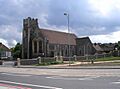
Methodist Church, Coulsdon

See also
 In Spanish: Coulsdon para niños
