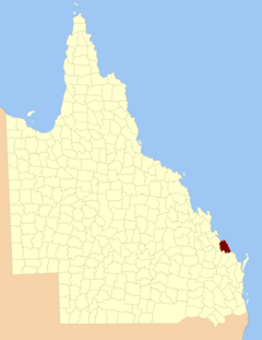
County of Flinders, Queensland facts for kids
Quick facts for kids FlindersQueensland |
|||||||||||||||
|---|---|---|---|---|---|---|---|---|---|---|---|---|---|---|---|

Location within Queensland
|
|||||||||||||||
|
|||||||||||||||
The County of Flinders is a special way of dividing land in Queensland, Australia. It's like an old-fashioned map boundary used for official records. You can find it in the Central Queensland area, between the cities of Gladstone and Bundaberg. This county is named after Matthew Flinders, a famous explorer who mapped parts of Australia's coast a long time ago.
How the County of Flinders Was Created
The County of Flinders was officially created a very long time ago, on 1 September 1855. This happened through a special announcement from the King or Queen, called a royal proclamation. It was part of a law about land in Australia.
Later, on 7 March 1901, the Governor of Queensland made another official announcement. This time, it legally divided Queensland into counties using a new land law. The announcement described the boundaries of Flinders like this:
It is bordered on the south by the counties of Cook and Bowen. To the west, it meets the county of Yarrol, the eastern side of the Boyne River, and the western edge of the Rodds Bay area. To the north and east, it is bordered by the Pacific Ocean.
Parishes within Flinders County
The County of Flinders is further divided into smaller areas called parishes. These are also used for keeping track of land. Here is a list of these parishes:
| Parish | Local Government Area | Coordinates | Towns |
|---|---|---|---|
| Arthurs Seat | Gladstone | 24°17′S 151°42′E / 24.283°S 151.700°E | |
| Baffle | Gladstone | 24°28′S 151°57′E / 24.467°S 151.950°E | |
| Bulburin | Gladstone | 24°32′S 151°34′E / 24.533°S 151.567°E | |
| Bunker | Gladstone | 23°46′S 152°22′E / 23.767°S 152.367°E | |
| Euleilah | Gladstone | 24°31′S 151°50′E / 24.517°S 151.833°E | |
| Eurimbula | Gladstone | 24°07′S 151°43′E / 24.117°S 151.717°E | Town of 1770 |
| Littabella | Bundaberg | 24°40′S 152°05′E / 24.667°S 152.083°E | Watalgan |
| Miriam Vale | Gladstone | 24°22′S 151°35′E / 24.367°S 151.583°E | Miriam Vale |
| Polmaily | Gladstone | 24°20′S 151°29′E / 24.333°S 151.483°E | Bororen |
| Rodds Bay | Gladstone | 24°06′S 151°32′E / 24.100°S 151.533°E | |
| Rosedale | Gladstone | 24°41′S 151°51′E / 24.683°S 151.850°E | Rosedale (S) |
| Taunton | Gladstone | 24°24′S 151°44′E / 24.400°S 151.733°E | |
| Thornhill | Gladstone | 24°39′S 151°36′E / 24.650°S 151.600°E | |
| Tottenham | Gladstone | 24°36′S 151°59′E / 24.600°S 151.983°E | Rosedale (N) |
| Uxbridge | Gladstone | 24°19′S 151°53′E / 24.317°S 151.883°E | Agnes Water |
| Warro | Gladstone | 24°33′S 151°44′E / 24.550°S 151.733°E | Lowmead |
 | Aaron Henry |
 | T. R. M. Howard |
 | Jesse Jackson |

