County of Cook, Queensland facts for kids
Quick facts for kids CookQueensland |
|||||||||||||||
|---|---|---|---|---|---|---|---|---|---|---|---|---|---|---|---|

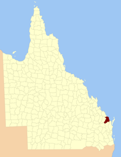
Location within Queensland
|
|||||||||||||||
|
|||||||||||||||
The County of Cook is a special way that land is divided in Queensland, Australia. Think of it like a big section of land used for official records. It's mainly around the city of Bundaberg. This county was named to honor the famous explorer, Captain James Cook.
The County of Cook was officially created on March 7, 1901. This happened when the Governor of Queensland and his advisors made it official under a law called the Land Act 1897. This law helped organize how land was used and owned across Queensland.
What is a Cadastral Division?
A cadastral division is a way to divide land for legal reasons. It helps governments keep track of who owns what land. It also helps with planning and managing different areas. The County of Cook is one of these divisions.
How is the Land Divided?
Just like a big county, the County of Cook is broken down into smaller areas. These smaller areas are called parishes. Parishes help to organize the land even more. Each parish has its own name and location. Some parishes include towns, while others are mostly rural areas.
Here is a list of the parishes within the County of Cook:
| Parish | LGA | Coordinates | Towns |
|---|---|---|---|
| Barns | Bundaberg | 25°01′S 152°26′E / 25.017°S 152.433°E | |
| Barolin | Bundaberg | 24°50′S 152°26′E / 24.833°S 152.433°E | Bargara, Burnett Heads, Elliott Heads |
| Bingera | Bundaberg | 25°02′S 152°16′E / 25.033°S 152.267°E | |
| Booyal | Bundaberg | 25°09′S 152°03′E / 25.150°S 152.050°E | Booyal |
| Broomfield | North Burnett | 25°27′S 152°12′E / 25.450°S 152.200°E | |
| Bundaberg | Bundaberg | 24°56′S 152°20′E / 24.933°S 152.333°E | Bundaberg, Avoca, Branyan |
| Burrum | Fraser Coast | 25°19′S 152°32′E / 25.317°S 152.533°E | Howard |
| Cherwell | Fraser Coast | 25°16′S 152°28′E / 25.267°S 152.467°E | |
| Childers | Bundaberg | 25°15′S 152°18′E / 25.250°S 152.300°E | Childers |
| Chowey | North Burnett | 25°28′S 151°52′E / 25.467°S 151.867°E | Didcot |
| Coringa | North Burnett | 25°21′S 151°57′E / 25.350°S 151.950°E | |
| Dallarnil | North Burnett | 25°22′S 152°04′E / 25.367°S 152.067°E | Dallarnil |
| Degilbo | North Burnett | 25°31′S 151°57′E / 25.517°S 151.950°E | Biggenden, Degilbo |
| Electra | Bundaberg | 25°04′S 152°08′E / 25.067°S 152.133°E | |
| Eureka | Bundaberg | 25°18′S 152°10′E / 25.300°S 152.167°E | |
| Gooburrum | Bundaberg | 24°47′S 152°20′E / 24.783°S 152.333°E | Bundaberg North, Gooburrum |
| Gregory | Bundaberg | 25°09′S 152°16′E / 25.150°S 152.267°E | Cordalba |
| Hercules | Bundaberg | 25°09′S 152°35′E / 25.150°S 152.583°E | Woodgate (S) |
| Isis | Bundaberg | 25°11′S 152°27′E / 25.183°S 152.450°E | Buxton |
| Kalkie | Bundaberg | 24°54′S 152°24′E / 24.900°S 152.400°E | Bundaberg East, Kalkie, Walkervale |
| Kinagin | Bundaberg | 24°50′S 152°01′E / 24.833°S 152.017°E | |
| Kolbore | Fraser Coast | 25°20′S 152°25′E / 25.333°S 152.417°E | |
| Kullogum | Bundaberg | 25°21′S 152°16′E / 25.350°S 152.267°E | |
| Marathon | Bundaberg | 25°06′S 152°26′E / 25.100°S 152.433°E | Goodwood, Woodgate (N) |
| Mungore | North Burnett | 25°35′S 152°04′E / 25.583°S 152.067°E | |
| North Kolan | Bundaberg | 24°47′S 152°12′E / 24.783°S 152.200°E | |
| Otoo | Bundaberg | 24°47′S 152°15′E / 24.783°S 152.250°E | Oakwood |
| South Kolan | Bundaberg | 24°55′S 152°10′E / 24.917°S 152.167°E | |
| Stanton | Bundaberg | 25°14′S 152°04′E / 25.233°S 152.067°E | |
| Takalvan | Bundaberg | 24°55′S 152°16′E / 24.917°S 152.267°E | |
| Tantitha | Bundaberg | 24°52′S 152°16′E / 24.867°S 152.267°E | Sharon |
| Walsh | Fraser Coast | 25°16′S 152°36′E / 25.267°S 152.600°E | Burrum Heads, Torbanlea |
| Woowoonga | North Burnett | 25°28′S 152°05′E / 25.467°S 152.083°E | |
| Yandaran | Bundaberg | 24°46′S 152°07′E / 24.767°S 152.117°E | Yandaran, Avondale |
 | Janet Taylor Pickett |
 | Synthia Saint James |
 | Howardena Pindell |
 | Faith Ringgold |

