Covington County, Mississippi facts for kids
Quick facts for kids
Covington County
|
|
|---|---|

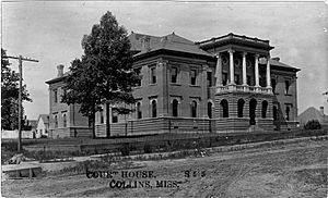
Covington County Courthouse
|
|

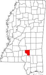
Location within the U.S. state of Mississippi
|
|
 Mississippi's location within the U.S. |
|
| Country | |
| State | |
| Founded | 1819 |
| Named for | Leonard Covington |
| Seat | Collins |
| Largest city | Collins |
| Area | |
| • Total | 415 sq mi (1,070 km2) |
| • Land | 414 sq mi (1,070 km2) |
| • Water | 1.1 sq mi (3 km2) 0.3% |
| Population
(2020)
|
|
| • Total | 18,340 |
| • Estimate
(2023)
|
18,059 |
| • Density | 44.19/sq mi (17.063/km2) |
| Time zone | UTC−6 (Central) |
| • Summer (DST) | UTC−5 (CDT) |
| Congressional district | 3rd |
Covington County is a place in Mississippi, a state in the United States. It's like a district or a region within the state. In 2020, about 18,340 people lived here. The main town, or "county seat," is Collins. The county got its name from Leonard Covington, who was an army officer and a congressman.
Contents
History of Covington County
Covington County was created on January 5, 1819. This was less than two years after Mississippi became a state. It was one of the first counties made from the large, undeveloped lands in the eastern part of the state.
Originally, Covington County was much bigger. It included areas that are now Jefferson Davis, Covington, and Jones Counties.
In 1823, a part of Covington County became Bainbridge County. This new county was probably named after William Bainbridge, a hero from the War of 1812. But just one year later, in 1824, the Mississippi government decided to get rid of Bainbridge County. Its lands were given back to Covington County.
Where is Covington County?
Covington County covers about 415 square miles. Most of this area, about 414 square miles, is land. Only a small part, about 1.1 square miles, is water.
Counties Nearby
Covington County shares its borders with several other counties:
- Smith County (to the north)
- Jones County (to the east)
- Forrest County (to the southeast)
- Lamar County (to the south)
- Jefferson Davis County (to the west)
- Simpson County (to the northwest)
Getting Around Covington County
Main Roads
Two important four-lane highways cross Covington County. They help people travel easily from north to south and east to west.
 U.S. Highway 49: This highway runs north and south through all three towns in the county. It connects Covington County to big cities like Jackson, Gulfport, and Hattiesburg. Many thousands of people use Highway 49 every day.
 U.S. Highway 84: This highway goes east to west and passes through the city of Collins. It links Covington County to other mid-sized cities such as Laurel, Brookhaven, and Natchez.
Smaller Roads
Many two-lane highways also run through Covington County. They connect larger cities with smaller communities.
- Mississippi Highway 35 (goes through Mt. Olive, Mize, Raleigh)
- Mississippi Highway 37 (from Collins to Taylorsville)
- Mississippi Highway 184 (in Collins, used to be Highway 84)
- Mississippi Highway 588 (from Collins to Ellisville)
- Mississippi Highway 598 (in Sanford)
- Mississippi Highway 589 (goes through Seminary, Sumrall, Purvis)
- Mississippi Highway 590 (from Seminary to Ellisville, also called Main Street Seminary)
- Mississippi Highway 532 (from Mt. Olive to Hopewell)
- Mississippi Highway 535 (from Seminary to Collins)
People in Covington County
| Historical population | |||
|---|---|---|---|
| Census | Pop. | %± | |
| 1820 | 2,230 | — | |
| 1830 | 2,551 | 14.4% | |
| 1840 | 2,717 | 6.5% | |
| 1850 | 3,338 | 22.9% | |
| 1860 | 4,408 | 32.1% | |
| 1870 | 4,753 | 7.8% | |
| 1880 | 5,993 | 26.1% | |
| 1890 | 8,299 | 38.5% | |
| 1900 | 13,076 | 57.6% | |
| 1910 | 16,909 | 29.3% | |
| 1920 | 14,869 | −12.1% | |
| 1930 | 15,028 | 1.1% | |
| 1940 | 17,030 | 13.3% | |
| 1950 | 16,036 | −5.8% | |
| 1960 | 13,637 | −15.0% | |
| 1970 | 14,002 | 2.7% | |
| 1980 | 15,927 | 13.7% | |
| 1990 | 16,527 | 3.8% | |
| 2000 | 19,407 | 17.4% | |
| 2010 | 19,568 | 0.8% | |
| 2020 | 18,340 | −6.3% | |
| 2023 (est.) | 18,059 | −7.7% | |
| U.S. Decennial Census 1790-1960 1900-1990 1990-2000 2010-2013 |
|||
In 2020, the county had 18,340 people living there. There were 6,759 households and 4,965 families.
Schools in Covington County
The Covington County School District is the only school district here. It runs nine schools, plus a special alternative school and a center for learning job skills.
Students in the county can also attend Jones College.
Fun Places to Visit
Okatoma River
The Okatoma River, also known as Okatoma Creek, flows through Covington County from north to south. It passes through three towns and eventually joins the Bouie River.
People from all over the Southeast come to the county to canoe and kayak on the river. You can rent canoes and kayaks from places like Okatoma Outdoor Post and Seminary Canoe Rental. They also offer places to stay near the river. The Okatoma River is known as one of the best spots for rafting in the South.
Mitchell Farms
Mitchell Farms is a popular farm located just east of Collins. It's a top spot for "agri-tourism" in southern Mississippi. Families and school groups visit the farm each year. They can explore the pumpkin patch, see old farm buildings, try a corn maze, and walk through a sunflower field. There are many other fun activities for families too.
Every October, Mitchell Farms hosts Mississippi's Peanut Festival. This festival includes a harvest king and queen contest, a 5K race, food, and activities for kids. Thousands of people come to enjoy it.
Grand Paradise Water Park
Grand Paradise Water Park in Collins is one of the biggest water parks in Mississippi. It covers seven acres! You can enjoy attractions like the Lazy River, Cannon Bowl, and Pipeline. The park also has food stands, lockers, changing areas, and a gift shop.
Towns and Communities
Cities
- Collins (This is the main town, or county seat)
Towns
Other Communities
- Hopewell
- Hot Coffee
- Lux
- Ora
- Sanford
- Williamsburg
Famous People from Covington County
- Dana Andrews: An actor who was also the president of the Screen Actors Guild. He was born near Collins.
- Ernest Duff: A businessman, lawyer, and religious leader.
- Steve McNair: A well-known former NFL quarterback.
- Martin Sennett Conner: He was the Governor of Mississippi from 1932 to 1936.
- Gerald McRaney: An actor.
- Dale Houston: A singer.
See also
 In Spanish: Condado de Covington (Misisipi) para niños

