
Crabtree Hot Springs, California facts for kids
Quick facts for kids
Crabtree Hot Springs
|
|
|---|---|
|
Private Property, closed to the public
|
|

Crabtree Hot Springs
|
|

Crabtree Hot Springs
Location in California
|
|
| Country | United States |
| State | California |
| County | Lake County |
| Crabtree Hot Springs | 1875 |
| Elevation | 2,257 ft (688 m) |
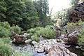
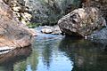
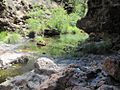
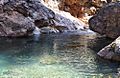
Crabtree Hot Springs is a natural wonder in Lake County, California. It is about 25 miles (40 km) north of Upper Lake. These hot springs are on private land and are not open to the public. They sit at an elevation of 2,257 feet (688 meters). There are four natural hot springs here. They are in a narrow canyon on the north side of the Rice Fork of the Eel River. Three springs are near a large swimming hole. The fourth spring is a bit further upstream. The hottest spring reaches 106°F (41°C). It flows at about 10 US gallons (38 L) per minute.
Contents
History of Crabtree Hot Springs

Around 1875, John Fletcher Crabtree (1824-1915) and his sons found these hot springs. They followed a well-used Native American trail. Local Native Americans believed the water had healing powers. Crabtree invited people to the springs for these health benefits. Many people strongly believed the springs could cure all kinds of sickness. Some even brought sick horses there and saw good results. The springs were never used to bottle water for sale. Instead, they became a popular resort.

About 1907, Samuel Tate Packwood (1842-1924) bought the property. He was a businessman from Upper Lake. Packwood planned to build a bigger resort at the springs. John Fletcher Crabtree lived at the springs for many years.
Minerals in the Water
Around 1900, people looked for quicksilver near the springs. They dug two tunnels into the canyon side. The rock had cinnabar, which is a mercury ore. However, they did not find enough to make it worth mining.
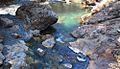
The rocks around the springs are called serpentine rock. This rock can be crushed into green clay or shiny black shales. At Crabtree Hot Springs, serpentine rock is visible in the creek bed. Other types of shale are on both sides. The springs come out where these different rocks meet.
The main spring flows into a natural rock pool. It is at the edge of the stream. This spring gives about 10 US gallons (38 L) of 106°F (41°C) water per minute. Gas, likely carbon dioxide, bubbles up with the water. The water is slightly fizzy and has minerals. These include salts of soda, sulfur, and possibly iron. People have used this pool for bathing for a long time. They believed the water helped with skin and blood issues.
Trails and Roads

Long ago, a historic Native American trail connected the springs to Twin Valleys and Bartlett Springs. The Crabtree family built the first wagon road from Twin Valleys to Crabtree Hot Springs. They also helped build the road from Twin Valleys to Bartlett Springs. The Crabtree family moved away from the springs before 1900. The road to the springs was then left unused and became hard to travel. Later, Samuel Packwood reopened this wagon road. At that time, it only went as far as the springs.
The Twin Valley Road was built by the Civilian Conservation Corps (CCC) in 1933-1934. The CCC was a program that gave jobs to young men during the Great Depression. Twin Valley Road (Forest Road 17N04) is about 40 miles (64 km) long. It connects the Upper Lake and Grindstone Ranger Districts in the southern Mendocino National Forest.
From Twin Valley Road, there is a short trail to the hot springs. This trail is about one-quarter mile long. It follows the Rice Fork river on its north side.
Another old Native American trail went from the hot springs down the Rice Fork canyon. It led to Gravelly Valley and then crossed the river. It continued up Squaw Valley Creek to a Native American village. Part of this trail is now under Lake Pillsbury.
There was also a well-used Native American trail from Upper Lake to the hot springs. The springs were a special place for them. A large rock at the springs is called Medicine Rock.
Nearby Attractions

The Hale Ridge Research Natural Area (RNA) is in the Mendocino National Forest. The Forest Service created it in 1987. It protects knobcone pine forests in the North Coast Ranges. This area has many knobcone pines. It is also a special home for the northern spotted owl, which is a protected bird. Black-tailed deer also use it as a winter home. The RNA has thick stands of knobcone pine and mixed conifer forests. These forests are mostly Douglas fir trees. They provide a home for the northern goshawk, another sensitive bird species. The RNA's northwestern border is next to the hot springs.
Bear Creek Campground is a free campground in the Mendocino National Forest. It is open all year. You can stay for up to 14 days. It has 16 picnic tables and grills, and two toilets. The campground is at an elevation of 2,000 feet (610 m). It is next to Bear Creek, near where it meets Blue Slides Creek. You can find it on Forest Road M-10 (County Road 301-C). This is about 9 miles (14 km) northeast of Elk Mountain Road. It is near the southern edge of the Snow Mountain Wilderness. It is about 6 miles (10 km) northwest of the hot springs.
Images for kids
-
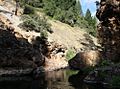
narrow winding steep walled canyon
-
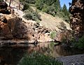
large swimming hole
-
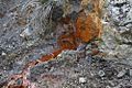
minerals flowing
-
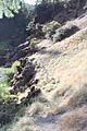
molten rock formations
-
Mendocino National Forest
-
medicine rock
-
Rice Fork Eel River
-
medicine rock
-

Rice Fork Eel River
-
high water
-

Wed-Sat 10am-4pm & Sunday noon-4pm
-
Lakeport Historic Courthouse Museum


